Description:
[?San Jose, CA,: Gist and Erdmann / Panoramic Productions,, 1990].. 730 by 740mm. (28.75 by 29.25 inches).. Colour printed poster. Pin holes in upper corners, water stain to upper left corner, trimmed along bottom edge. An entertaining pictorial map poster showing silicon valley in 1991, at the dawn of the internet age. This poster was created as a marketing tool for Seagate Technology, a company based in Cupertino that specialises in data storage hardware. Seagate was founded in 1978 by Al Shugart and partners. In 1980, they released their first hard disc drive, the ST-506. Their product was a hit, and they soon secured the contract to produce disc drives for IBM's newest microcomputer, the IBM XT, the first personal computer with a built in hard disk. 1991 was a seminal year for the company, marking the return of Al Shugart as CEO and the release of their most popular product line, the Barracuda HDD, the first drive with a 7200 rpm speed. Since then, Seagate has remained at the forefront of the…
Read More Search Results: Authors starting with B from Daniel Crouch Rare Books Ltd
You searched for:
- Bookseller inventory: Daniel Crouch Rare Books Ltd (authors starting with B)
- Bookseller: Daniel Crouch Rare Books Ltd
Results 1 - 20 of 102
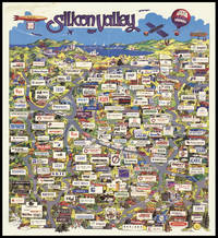
Silicon Valley 1991: Seagate's promotional poster map of Silicon Valley
by BACH PHI, P. [for Seagate Technology]
- Used
- Condition
- Used
- Quantity Available
- 1
- Seller
-
London, United Kingdom
- Item Price
-
£8,000.00£15.00 shipping to USA
Show Details
Item Price
£8,000.00
£15.00
shipping to USA
Map of Kensington and neighbourhood.: Hops, reformation, turkeys, carp, and beer, came into England all in one year" Issued by Henry Lovibond and Son, Cannon Brewery, North End, Fulham, S.W.
by BACON, G[eorge] W[ashington]
- Used
- Hardcover
- Condition
- Used
- Binding
- Hardcover
- Quantity Available
- 1
- Seller
-
London, United Kingdom
- Item Price
-
£1,500.00£15.00 shipping to USA
Show Details
Description:
London,: Bacon's Map Establishment, 127 Strand,, 1880.. 760 by 1080mm. (30 by 42.5 inches).. Lithograph map with original hand colouring, dissected and laid on linen, folding into red cloth covers, lettered in gilt, pricelist and instructions labels on pastedowns, upper board detached. George Washington Bacon (1830-1922) was an American publisher working in Britain. His first business failed and he declared bankruptcy in 1867, but reopened on the Strand in 1870 and built his house into one of the most successful in London. The map of Kensington spans from Paddington to the north and Fulham to the south, and Hammersmith to the west and Green Park to the east. It prominently shows the Henry Lovibond & Son Cannon Brewery on the Lillie Road highlighted with red circles radiating from it in half mile increments, with the first being a quarter mile in distance. Henry Lovibond (c.1840-1910) was a brewer from Clerkenwell who acquired 'The Hermitage' villa and the remnants of its park on the corner of…
Read More Item Price
£1,500.00
£15.00
shipping to USA

Bacon's large-print map of the Transvaal: Bacon's rare map of the Transvaal
by BACON, G[eorge], W[ashington]
- Used
- Condition
- Used
- Quantity Available
- 1
- Seller
-
London, United Kingdom
- Item Price
-
£100.00£15.00 shipping to USA
Show Details
Description:
London, : G. W. Bacon & Co., Ltd., 127 Strand,, [c1899].. 560 by 755mm. (22 by 29.75 inches).. Lithograph map in full-colour, with three inset maps, laid on cardboard, two small holes on right border with minimal effect on image. This rare map of the Transvaal, or the South African Republic, was produced and sold to the general public in London, at a time when the British Empire was approaching the pinnacle of its global influence. Made in 1899, it displays the southern African states on the verge of the Second Boer Wars, which would see the Transvaal transformed from an independent republic to a British possession. Despite its nominal focus on the South African Republic, the map predictably gives special prominence to the British colonies, represented in pink. The same is true of the inset maps along the right border: Cape Colony is labelled in the largest script on the map of Africa, and similarly, the map that claims to show Orange Free State is actually dominated by the British territory. The…
Read More Item Price
£100.00
£15.00
shipping to USA
![[Pair of maps of India] North India [and] South India.](https://d3525k1ryd2155.cloudfront.net/h/216/910/1162910216.0.m.jpg)
More Photos
[Pair of maps of India] North India [and] South India.: A pair of large London Missionary Society Maps of India
by BACON, G[eorge] W[ashington]
- Used
- Hardcover
- Condition
- Used
- Binding
- Hardcover
- Quantity Available
- 1
- Seller
-
London, United Kingdom
- Item Price
-
£2,200.00£15.00 shipping to USA
Show Details
Description:
London,: G.W. Bacon & Co., 127 The Strand,, [c1900].. (north India) 1110 by 1500mm. (43.75 by 59 inches); (south India) . Pair of lithograph maps on linen, each map on two sheets joined. Rare pair of large wall maps depicting North and South India, Tibet, and Sri Lanka. All major cities are marked together the London Missionary Society's (L.M.S.) stations. Topographical features include rivers, and mountains. The text to the foot of each map implies the main role of these maps was to provide a survey of the L.M.S. stations in India. The cloth cloth loops at the top of each map, show that they were intended to be hung on a wall, of most probably a classroom or an office of the L.M.S. George Washington Bacon (1830-1922) was an American publisher working in Britain. His first business failed and he declared bankruptcy in 1867, but reopened on the Strand in 1870 and built his house into one of the most successful in London. In 1893 it was doing well enough to acquire the stock of James Wyld. He retired…
Read More Item Price
£2,200.00
£15.00
shipping to USA

L'Asie divisé suivant l'etendue des Empires et Royaumes qui la partagent: A rare map of Asia showing the Sea of Korea Et des dominations établies par les Castillans les Portugais les François et les Hollandois avec des Nottes Historiques et Géographiques Extraitz de la Martinier et autres Autheurs. Dédiée et Presentée a M
by BAILLEUL, N[icolas, Le Jeune]
- Used
- Condition
- Used
- Quantity Available
- 1
- Seller
-
London, United Kingdom
- Item Price
-
£6,000.00£15.00 shipping to USA
Show Details
Description:
Lyon,: Daudet, rue Merciere,, 1748.. 530 by 730mm. (20.75 by 28.75 inches).. Engraved map, border text on the sides, some original outline colour, top right corner missing and affecting the text, skilfuly repaired. The map covers the entire Asian continent, stretching from Africa and the Mediterranean in the west to the Bering Sea in the east, and north to south from the island of Nova Zembla to Java and New Guinea. The title clarifies that the names on the map are those established by the Spanish, the Portuguese, the French, and the Dutch. The border text provides descriptions derived from 'Le Grand Dictionnaire Géographique Et Critique' published by de la Martinière in 1738. Interestingly, the sea between Japan and Korea is here identified in favour of Korea (Mer de Corée), as opposed to 'East Sea' or the 'Sea of Japan'. The first trace of the 'Sea of Korea' appears on the 1615 map of Asia by Godinho de Eredia, a Malayan-Portuguese cartographer and mathematician. Later on, Dudley, Bowen, and…
Read More Item Price
£6,000.00
£15.00
shipping to USA

The Mail Arriving at Temple Bar.: Entering the City
by BAILY, J. after NEWHOUSE, C[harles] B.
- Used
- Condition
- Used
- Quantity Available
- 1
- Seller
-
London, United Kingdom
- Item Price
-
£250.00£15.00 shipping to USA
Show Details
Description:
London,: Published by J. Watson, 7 Vere Street, Cavendish Square,, July, 1834.. Image: 292 by 414mm (11.5 by 16.25 inches). Sheet: 356 by 450mm (14 by 17.75 inches).. Engraving with aquatint and contemporary colour, closed tear to title and just into image. A nightime scene showing the Devonport Royal Mail coming in through Temple Bar in the Strand, heading to the Lombard Street Post Office. Temple Bar marks the boundary between the City of London and Westminster; the gate is topped by statues of King James I and his wife, Anne of Denmark, with the lion and unicorn supporters from the royal coat of arms. The guard at the back of the carriage is blowing a trumpet to warn passengers and the gatekeepers of their arrival, and has awakened a figure in nightcap and gown who peers from the window to the right. The passage of the coach is observed by a traveller with a carpet bag and a night watchman with a torch hanging from his belt, who would patrol the streets and call out the times. Charles B.…
Read More Item Price
£250.00
£15.00
shipping to USA

N.B. Maps, Charts, & c. Accurately Engrav'd.
by BAKER, Benjamin
- Used
- Condition
- Used
- Quantity Available
- 1
- Seller
-
London, United Kingdom
- Item Price
-
£2,000.00£15.00 shipping to USA
Show Details
Description:
Islington,: Near the Thatch'd House, Lower Street,, [c1798-1800].. 115 by 75mm (4.5 by 3 inches).. Maps,""Benj. Baker Engraver... Trade card with a miniature map of Georgian Islington Engraved trade card. Benjamin Baker's (1766-1841) trade card includes a detailed miniature map of Islington, where he had premises from at least 1791-1800. A key to the upper right lists schools, religious houses, alms houses, and a turnpike road. Baker became a prolific producer of engraved maps from the late eighteenth century onwards, including for William Faden. As a map engraver and publisher, he resided first at 32 High Street, Islington from 1791-1793 and then in Lower Street, Islington from 1798-1800. In 1804, he became principal engraver to the Ordnance Survey and he and his firm were regarded as """"the best topographical engravers in Europe"""" (Seymour). There he worked with his three sons: Benjamin Richard (1792-1876), one of the initial surveyors who did the Survey of Ireland from 18241845; Alfred…
Read More Item Price
£2,000.00
£15.00
shipping to USA

This Porcineograph.: America Hams it Up This Good Cheer Souvenir.
by BAKER, W[illiam] E[merson].
- Used
- Condition
- Used
- Quantity Available
- 1
- Seller
-
London, United Kingdom
- Item Price
-
£12,000.00£15.00 shipping to USA
Show Details
Description:
Boston,: W. E. B[aker], 13 West Street, Boston, Mass.,, 1876.. Multi-stone lithograph. This map depicts the United States as a pig, with the snout at Maine and two legs represented by the peninsulas of Florida and Baja. A third leg rests on Cuba, drawn in the shape of a sausage, and the fourth on the Sandwich Islands, drawn-naturally-as a cluster of sandwiches. The "GEHOGRAPHY," as the author refers to it, is surrounded by the seals of the states and the names of their favoured pork-based dishes. Two vignettes at lower left and right illustrate events-both involving pigsthat resulting in litigation or legislation that changed the course of American history. The map was designed by one William Emerson Baker (1828-1888), who intended it to serve simultaneously as a keepsake, promotional piece and symbol of national unity: "whose successful Grover & Baker Sewing Machine Company produced accessibly-priced units for home use, retired in 1868 at the age of forty. He moved to a large farm in Needham,…
Read More Item Price
£12,000.00
£15.00
shipping to USA

Sells all sorts of maps and prints for exportation. Glass, paintings & pictures in oyl for chimney pieces, and makes all sorts of frames in the neatest manner. Stair cases and rooms neatly fitted up with Indian pictures & all sorts of liquid collours for surveyors.
by BAKEWELL, Elizabeth
- Used
- Condition
- Used
- Quantity Available
- 1
- Seller
-
London, United Kingdom
- Item Price
-
£1,500.00£15.00 shipping to USA
Show Details
Description:
London,: against the end of Birchin Lane in Cornhill, , [c1749].. 59 by 69mm. (2.25 by 2.75 inches).. Prints,""Map & printseller Trade card for lady map and print seller Engraved trade card. Elizabeth Bakewell (fl1749-1770s) was a print seller and publisher who continued in business after her husband, Thomas Bakewell, died. She worked alongside Henry Parker, Thomas's former assistant. Bakewell's trade card is identical to that of her late husband, Thomas, with the exception of the change in name. The top section of the trade card highlights a number of different types of prints and maps on offer, which are presented as if they are pasted to a wall, including a 'Map of the World', partially obscured by portrait prints and another map that appear to be tacked on top of it. This may very well be the world map Thomas produced in partnership with Timothy Jordan, which was advertised in the 'Daily Courant' on 3 July 1729. Also visible is John Harris's view of Blenheim entitled """"East Front of Blenheim…
Read More Item Price
£1,500.00
£15.00
shipping to USA

A Panoramic View of London.: Bank's view of London
by BANKS, J[ohn]. H[enry], by and after
- Used
- Condition
- Used
- Quantity Available
- 1
- Seller
-
London, United Kingdom
- Item Price
-
£1,600.00£15.00 shipping to USA
Show Details
Description:
London,: Entered at Stationer's Hall & Published as the Act Directs by Edward Wallis, No.42, Skinner St, Snow Hill,, [c.1845].. Image: 398 by 995mm (15.75 by 39.25 inches). Sheet: 490 by 1060mm (19.25 by 41.75 inches).. Copper engraving with aquatint with contemporary hand-colour. The third state of the print, with title changed to: 'A Panoramic View of London', here uncoloured. BL Maps 162.n.2.
Item Price
£1,600.00
£15.00
shipping to USA

Geograph des Franz. Ministeriums der auswartigen Angelegenheiten.
by BARBIE DU BOCAGE, Jean-Denis] [WESTERMAYER, Conrad]
- Used
- Condition
- Used
- Quantity Available
- 1
- Seller
-
London, United Kingdom
- Item Price
-
£200.00£15.00 shipping to USA
Show Details
Description:
[Weimar: Friedrich Justin Bertuch,, 1803].. 140 by 90mm. (5.5 by 3.5 inches).. Prints,""Jean Denys Barbié du Bocage Jean-Denis Barbié du Bocage Stipple-engraved portrait. In 1798, German astronomer Franz Xaver von Zach partnered with influencial publisher Friedrich Justin Bertuch to launch the very first astronomical-geographical journal, the 'Allgemeine geographische Ephemeriden'. Depsite disputes between Zach, who had in mind a purely scientific journal, and Bertuch, who wanted to produce an educational magazine for the enthusiast, the AGE continued to appear under a variety of names until 1831. In 1803, the twelfth volume of 'Allgemeine Geographische Ephemeriden' featured a portrait of Jean-Denis Barbié du Bocage (1760-1825), the only student taken on by the important French geographer Jean-Baptiste Bourguignon d'Anville. With this promising training, Barbié du Bocage went on to enter government in a cartographical capacity, taking charge of the geographical department of the Bibliothèque…
Read More Item Price
£200.00
£15.00
shipping to USA

A large & fashionable assortment of ready made Waistcoats, under d. Pantaloons, Overalls, Cotton & Elastic, drawers, Dressing Gowns &c.
by BARLOW & JENKINS, [Thomas]
- Used
- Hardcover
- Condition
- Used
- Binding
- Hardcover
- Quantity Available
- 1
- Seller
-
London, United Kingdom
- Item Price
-
£250.00£15.00 shipping to USA
Show Details
Description:
[London],: No. 27, Fleet Street, opposite St. Dunstans Church,, [1803-1812].. 100 by 75mm (4 by 3 inches).. Prints,""Barlow & Jenkins, Mercers & Taylors... D is for Draper Engraved trade card Trade card for Barlow & Jenkins, tailors and mercers of 27 Fleet Street, London. In 'Kent's Directory' of 1803, """"Barlow & Hopkins, Drapers & Mercers, 27, Fleet-street"""" are listed, while 'The Post-Office Annual Directory for 1812' names only Thomas Jenkins at the premises. Given the similarity in the names, it is quite possible, even likely, that 'Hopkins' is a misspelling of 'Jenkins', the result of a communication or chirographical error. This suggests that the partnership between Barlow and Jenkins may have broken up some time between 1803 and 1812, with the latter continuing the business on his own. The premises appear to have been used as a tailors shop from around the turn of the nineteenth century, with 'Wakefield's Merchant and Tradesman's General Directory for London' of 1793 listing 27 Fleet…
Read More Item Price
£250.00
£15.00
shipping to USA

NB. Blinds Painted and Repaired.
by BARRON, [James] & MILLS
- Used
- Condition
- Used
- Quantity Available
- 1
- Seller
-
London, United Kingdom
- Item Price
-
£200.00£15.00 shipping to USA
Show Details
Description:
London,: 72 Wells Street, Oxford Street,, [c1834-1839].. 60 by 90mm. (2.25 by 3.5 inches).. Prints,""Barron & Mills, Patent Blind Manufacturers... V is for Venetian Blind Maker Engraved trade card. James Barron first appears in the records in Holden's 'Triennial Directory' for the years 1805 to 1807, where he is listed as a Venetian blind maker active at Edgbaston Street, Birmingham. In 1820, Barron, who then occupied 73 Wells Street, London and 11 Lower Temple Street, Birmingham published a pamphlet addressed """"to cabinet-makers and upholsterers in general"""" and entitled """"Modern and Elegant Designs of Cabinet & Upholstery Furniture"""". The bulk of the work was taken up with charming illustrations of various pieces of furniture, and also included a explanation of """"Barron's Patent Roller Blinds"""", a list of materials used and stocked by Barron at his shops, as well as a price list. 'The London Upholsterer's Companion' of 1834 lists Barron and Mills of both 72 and 73 Wells Street as…
Read More Item Price
£200.00
£15.00
shipping to USA

Indian Archipelago: Bartholomew's Southeast Asia
by BARTHOLOMEW, J.
- Used
- Condition
- Used
- Quantity Available
- 1
- Seller
-
London, United Kingdom
- Item Price
-
£150.00£15.00 shipping to USA
Show Details
Description:
London,: A. Fullarton,, [1858]. 470 by 585mm. (18.5 by 23 inches).. Hand-coloured engraved map. Map of the Indonesian Archipelago showing Dutch territorial possessions.
Item Price
£150.00
£15.00
shipping to USA

as incorporated & defined by Act of Parliament 1832. Embracing & Marking the Boundaries of the Parishes of St Marylebone, St Pancras, & Paddington: also the extents and limits of the Principal Landed Estates with the Borough: and Plans & Elevations of the Buildings. Engraved by B.R. Davies, from Surveys & Drawings by J.A. Bartlett under the direction of John Britton F.S.A &c. &c. &c. Inscribed to the Dukes of Bedford, Portland, & St. Ablans, The Marquis Camden, The Lord Bishop of London, Lords Mansfield and Southampton, E.B. Portman, Esq. & other Landed Proprietors.
by BARTLETT, F.A.
- Used
- Condition
- Used
- Quantity Available
- 1
- Seller
-
London, United Kingdom
- Item Price
-
£6,500.00£15.00 shipping to USA
Show Details
Description:
London,: J. Britton, Burton Str., J. Taylor, 30 Upper Gower Str., & B.R. Davies, 16 George Str. Euston Squ.,, 1834.. 1145 by 950mm (45 by 37.5 inches).. Maps,""Topographical Survey of the Borough of St. Marylebone, Rare large-scale plan of Marylebone Folding engraved map with contemporary hand-colour in full, dissected and mounted on linen. The plan depicts the parliamentary constituency of Marylebone, which was brought into existence by the Great Reform Act of 1832; the constituency would last until 1885, when it was then split into eight new divisions. Marylebone returned two members to Parliament in 1832: the Liberals, Viscount Portman - to whom the plan is dedicated, among others - and Sir William Horne. The commissioners had recommended that the part of St Pancras parishes north of the Regent's Canal should not form part of the constituency and should remain in the parliamentary county of Middlesex as this was still a largely rural area - as can be seen upon the present plan. However, the…
Read More Item Price
£6,500.00
£15.00
shipping to USA

as incorporated & defined by Act of Parliament 1832. Embracing & Marking the Boundaries of the Parishes of St Marylebone, St Pancras, & Paddington: also the extents and limits of the Principal Landed Estates with the Borough: and Plans & Elevations of the Buildings. Engraved by B.R. Davies, from Surveys & Drawings by J.A. Bartlett under the direction of John Britton F.S.A &c. &c. &c. Inscribed to the Dukes of Bedford, Portland, & St. Ablans, The Marquis Camden, The Lord Bishop of London, Lords Mansfield and Southampton, E.B. Portman, Esq. & other Landed Proprietors.
by BARTLETT, F. A.
- Used
- Condition
- Used
- Quantity Available
- 1
- Seller
-
London, United Kingdom
- Item Price
-
£6,500.00£15.00 shipping to USA
Show Details
Description:
London,: J. Britton, Burton Str., J. Taylor, 30 Upper Gower Str., & B.R. Davies, 16 George Str. Euston Squ.,, 1838.. 1145 by 950mm (45 by 37.5 inches).. Maps,""Topographical Survey of the Borough of St. Marylebone, Rare large-scale plan of Marylebone Large engraved map with original hand-colour in full, laid down on linen in 20 sections; a few folds with minor abrasions, case defective. The plan depicts the parliamentary constituency of Marylebone, which was brought into existence by the Great Reform Act of 1832; the constituency would last until 1885, when it was then split in eight new divisions. Marylebone returned two members to Parliament in 1832: the Liberals, Viscount Portman - to whom the plan is dedicated - and Sir William Horne. The commissioners had recommended that the part of St Pancras parishes north of the Regent's Canal should not form part of the constituency and should remain in the parliamentary county of Middlesex as this was still a largely rural area - as can be seen upon the…
Read More Item Price
£6,500.00
£15.00
shipping to USA

Vue de la Terrasse de Chester du Colisée des Places de St André et du Parc, au Parc du Régent à Londres.: The London Colosseum
by BASSET, [Paul-André]
- Used
- Condition
- Used
- Quantity Available
- 1
- Seller
-
London, United Kingdom
- Item Price
-
£750.00£15.00 shipping to USA
Show Details
Description:
Paris,: chez Basset, Rue St Jacques No. 64,, [1830].. Image: 251 by 402mm (10 by 15.75 inches). Sheet: 331 by 460mm (13 by 18 inches).. Engraving and etching with original hand colour. The building in the print is the 'Diorama' or London Colosseum. The Colosseum was purpose-built to house an enormous panoramic painting of London created by the artist Thomas Hornor and E.T. Harris. Hornor had made the drawings for the panorama from a temporary hut built on top of St Paul's Cathedral while the cross on the dome was being replaced. It took four years for Harris and a team of painters to complete it, and the painting covered over 40,000 square feet. The building which housed the panorama, based on the Pantheon, was designed by Decimus Burton. The painting and building together were so costly that a major backer, the politician Rowland Stephenson, ended up fleeing to America to avoid his debts, as did Hornor. Paul-André Basset was a French dealer and publisher active in the late eighteenth and early…
Read More Item Price
£750.00
£15.00
shipping to USA

Amstelodamum Urbs Hollandiae Primaria, Emporium Totius Europae Celeberium.: One of the most influential maps of Amsterdam
by BAST, Pieter
- Used
- first
- Condition
- Used
- Quantity Available
- 1
- Seller
-
London, United Kingdom
- Item Price
-
£60,000.00£15.00 shipping to USA
Show Details
Description:
Amsterdam,: Claes Jansz. Visscher,, [c1618].. (if joined) 940 by 825mm. (37 by 32.5 inches).. Engraved map on four sheets, joined. The final state of one of the most famous and influential maps of Amsterdam, first published in 1597. Pieter Bast (c.1550-1605) produced the first town plan of Amsterdam for half a century, updating Cornelis Anthonisz's woodcut view of 1544. He may also have drawn on Braun and Hogenberg's view of Amsterdam from 'Civitates Orbis Terrarum' (1572) (see item 11). It became the standard "for the critical period to 1625, the year of Balthasar Florisz van Berkenrode's celebrated ground plan. During these three decades prior to 1625 Amsterdam evolved from a provincial emporium to a world capital ... Bast recorded the appearance of Amsterdam at a singularly momentous point in its history ... Bast's print is no mere representation; it is a portrait" (Keyes). As the primacy of Antwerp in the Low Countries slipped away at the end of the sixteenth century, Amsterdam moved to take its…
Read More Item Price
£60,000.00
£15.00
shipping to USA

More Photos
Die Erde wie sie jezt bekant J.B.B.: Bauer's miniature nesting globes
by BAUER, J[ohann] B[ernard]
- Used
- Condition
- Used
- Quantity Available
- 1
- Seller
-
London, United Kingdom
- Item Price
-
£16,000.00£15.00 shipping to USA
Show Details
Description:
Nuremberg,: J.B. Bauer,, [c1810].. Diameter: 58mm and 64mm (2.25 inches and 2.5 inches) respectively.. Terrestrial and celestial nesting globes, the terrestrial globe with 12 hand-coloured engraved paper gores, over a wooden sphere, housed within the celestial globe made of two wooden hemispheres, each covered with 12 hand-coloured engraved paper half-gores, varnished, housed within original cylindrical case covered with gray paper with red wax seal on top with crown above the letters "Hv K". Short split in southern hemisphere of celestial globe, some loss to paper on case. Biography Johann Bernard Bauer (1752-1839) was a scientific instrument and globemaker working in Nuremberg, along with his sons Carl Johann Sigmund (1780-1857) and Peter Bauer (1783-1847). Johann is recorded as the engraver of a celestial globe by Georg Klinger in 1790; he also published some late editions of the Doppelmayr globes. His sons are best known for their miniature globes published for the educational market. Geography…
Read More Item Price
£16,000.00
£15.00
shipping to USA

Bauerkeller's New Embossed Plan of London 1841: George Bauerkeller's rare and strikingly modern embossed plan of London with its Index
by BAUERKELLER, G[eorge]
- Used
- Condition
- Used
- Quantity Available
- 1
- Seller
-
London, United Kingdom
- Item Price
-
£7,500.00£15.00 shipping to USA
Show Details
Description:
Paris & London,: Published by Ackerman & Co., 96 Strand,, 1841.. 680 by 1160mm. (26.75 by 45.75 inches).. Hand-coloured engraved embossed map, dissected and mounted on linen, inset of the Isle of Dogs, tables of the population of London and key to the maps colouring, folding into brown paper slipcase, with tree branch pattern. This extraordinary embossed plan shows each locality in a different colour and built up areas raised in white, similar to the technique of Braille. Extending from Islington in the north to Kennington in the south and from Kensington High Street in the west to the West India Docks, with an inset of Greenwich at a smaller scale. A unique style of cartography in very good condition. In an advertisement in the 'Sporting Magazine Advertiser' Ackermann announces its publication: '... The Buildings are raised, and, with the Railroads, Parks, Squares, &c. apper very prominent. The Parishes are also distinguished in delicate tints., and the entire arrangement is so remarkably…
Read More Item Price
£7,500.00
£15.00
shipping to USA

Didn’t find what you’re looking for?
Try adding this search to your want list. Millions of books are added to our site everyday and when we find one that matches your search, we’ll send you an email. Best of all, it’s free.
Add to Want List

Are you a frequent reader or book collector?
Join the Bibliophile's Club and save 10% on every purchase, every day — up to $20 savings per order!

Social Responsibility
Did you know that since 2004, Biblio has used its profits to build 16 public libraries in rural villages of South America?
