Description:
London, 1887. Lithograph, 62 x 52 cms, original colour, blank verso; from the first trade edition of Stanford’s London Atlas. Edward Stanford (senior) acquired Arrowmsith's stock in 1874. His own version of the London Atlas, dedicated to Queen Victoria in her Golden Jubilee year, is considered to be his last significant work before his retirement. Later editions were revised in keeping with the latest information. Map
Search Results: Asia: General, Western from Bryars and Bryars
You searched for:
- Subject: Asia: General, Western from Bryars and Bryars
Results 1 - 20 of 43

Asia
by Stanford, Edward:
- Used
- first
- Condition
- Used
- Quantity Available
- 1
- Seller
-
London, United Kingdom
- Item Price
-
£150.00£5.95 shipping to USA
Show Details
Item Price
£150.00
£5.95
shipping to USA

Asia
by Johnston, Alexander Keith:
- Used
- Condition
- Used
- Quantity Available
- 1
- Seller
-
London, United Kingdom
- Item Price
-
£75.00£5.95 shipping to USA
Show Details
Description:
London, 1876. Lithographed map, 45 x 57 cms, original colour, light waterstaining in upper margin, blank verso; from the ‘Royal Atlas of Modern Geography’. Map
Item Price
£75.00
£5.95
shipping to USA
Asia
by Wallis, James:
- Used
- Condition
- Used
- Quantity Available
- 1
- Seller
-
London, United Kingdom
- Item Price
-
£125.00£5.95 shipping to USA
Show Details
Description:
London, Samuel Augustus Oddy, 1811. Copper engraving, 30 x 25 cm, original hand-colour, latitude adjusted by 10 degrees in faint pencil in the lower margin, blank verso; published in ‘Oddy’s New General Atlas of the World’. New South Wales appears here on the west coast of ‘New Holland’. James Wallis (fl. 1810-1825) was born in Southampton in 1784, the son of a bricklayer. Apprenticed to John Roper in 1799, he learned the art of engraving. In later life he is variously recorded as a commission and discount agent (imprisoned for debt in 1835), a stationer, and a dealer in beer and wine.
Map
Item Price
£125.00
£5.95
shipping to USA
Asia secundum legitimas Projectionis Stereographicae... a Ioh. Matth. Hasio...
by Homann Heirs:
- Used
- Condition
- Used
- Quantity Available
- 1
- Seller
-
London, United Kingdom
- Item Price
-
£500.00£5.95 shipping to USA
Show Details
Description:
Nuremberg, 1744. Copper engraving, 51 x 58.5 cm, original hand colour, one or two light creases and a few light marginal spots and stains, blank verso. Map of the continent of Asia prepared for the Homann firm by Johann Matthias Hase, professor of mathematics in Wittemberg, on his stereographic horizontal projection; Hase died in 1742, and many of his maps were published posthumously. This is a variant of the map, with a dedication to Christian Gottlieb Graf von Holtzendorff (1696-1755) by August Gottlob Böhme (1719-1797), set within an elaborate vignette engraved by F.M. Regensus and dated 1744. The founder of the Homann business, Johann Baptist Homann (1664-1724), was a self-taught copper engraver who founded the leading German cartographic publishing house of the eighteenth-century. He was appointed cartographer to the Holy Roman Emperor in 1715, and his maps were sold throughout Europe. After Homann's death the business was continued by his son, Johann Christoph, and then by the Homann…
Read More Item Price
£500.00
£5.95
shipping to USA
Asia veteribus nota. L'Asie ancienne, dirigée par M. Philippe
by Philippe de Prétot, Étienne-André:
- Used
- Condition
- Used
- Quantity Available
- 1
- Seller
-
London, United Kingdom
- Item Price
-
£100.00£5.95 shipping to USA
Show Details
Description:
Paris, 1787. Copper engraving, 29 x 41 cm, engraved by Moithy after Herault, black and white, blank verso. Map of Asia as understood in the Greco-Roman world in classical antiquity; subsequent European discoveries are shown in outline. Map
Item Price
£100.00
£5.95
shipping to USA

Asie
by Levasseur, Victor:
- Used
- Condition
- Used
- Quantity Available
- 1
- Seller
-
London, United Kingdom
- Item Price
-
£125.00£5.95 shipping to USA
Show Details
Description:
Paris, c. 1850. Steel engraving, engraved area 32 x 44.5 cms, original hand-colour, elaborate border by Raimond Bonheur, engraved by Laguillermie, blank verso. From an edition of Levasseur’s ‘Atlas National Illustré’. Map
Item Price
£125.00
£5.95
shipping to USA
Bengala - Descriptio Bengalae
by Bertius, Petrus:
- Used
- first
- Condition
- Used
- Quantity Available
- 1
- Seller
-
London, United Kingdom
- Item Price
-
£125.00£5.95 shipping to USA
Show Details
Description:
Amsterdam, Jodocus Hondius, 1616. Copper engraving, each 9.7 x 13.5 cms, black and white, Latin text on verso. The Bay of Bengal, from the first edition of Tabularum geographicarum contractarum libri, a geographical work which is normally catalogued under the name of its author, Bertius. The maps are generally reduced from the cartography in the folio Mercator-Hondius atlas, and were mostly engraved by Jodocus Hondius, eldest son of the printer, who also bears the same name. Geoffrey King calls them "undoubtedly the finest set of miniature maps ever printed" (Miniature Antique Maps p. 96). Map
Item Price
£125.00
£5.95
shipping to USA
British India, Southern Part.
by Thomson, John:
- Used
- Condition
- Used
- Quantity Available
- 1
- Seller
-
London, United Kingdom
- Item Price
-
£200.00£5.95 shipping to USA
Show Details
Description:
Edinburgh, 1816. Copper engraving, approx 53 x 65 cm, engraved by Neele, original hand-colour, vertical crease in left hand part of the map, blank verso, published in Thomson’s ‘New General Atlas’. The map covers the southern part of the subcontinent (Mumbai is near the upper border), and includes the northern part of Sri Lanka. Pink denotes territory controlled by the British East India Company, although the political situation was constantly evolving. For example, the Kingdom of Kandy in Sri Lanka is coloured as an independent state, but had become a British protectorate following the Kandyan Convention of 1815 (it definitively lost its autonomy following the Uva Rebellion of 1817). ‘Neele’ could be either (or both) George or Samuel John Neele, brothers who collaborated in engraving maps for the highly successful 'New General Atlas', which made Thomson’s fortune. Unfortunately for Thomson he later bankrupted himself, twice, in the process of creating his…
Read More Item Price
£200.00
£5.95
shipping to USA
Burma and adjacent Countries
by Stanford, Edward:
- Used
- Condition
- Used
- Quantity Available
- 1
- Seller
-
London, United Kingdom
- Item Price
-
£175.00£5.95 shipping to USA
Show Details
Description:
London, 1894. Lithograph, 71.5 x 51 cms, colour printed, blank verso; published in the second trade edition of Stanford’s London Atlas. Edward Stanford (senior) acquired Arrowmsith's stock in 1874. His own version of the London Atlas, published in 1887 and dedicated to Queen Victoria in the year of her Golden Jubilee, is considered to be his last significant work before his retirement. Later editions were revised in keeping with the latest information. Map
Item Price
£175.00
£5.95
shipping to USA
Calcutta Tourist Map
by Thomas, Brigadier R.H.; Survey of India:
- Used
- Paperback
- Condition
- Used
- Binding
- Paperback
- Quantity Available
- 1
- Seller
-
London, United Kingdom
- Item Price
-
£325.00£5.95 shipping to USA
Show Details
Description:
Calcutta: Survey of India, 1929. Detailed plan of Calcutta, 73.5 x 64.5 cms, black and white, laid on linen as issued, folding into printed stiff paper wraps. Old ownership signature (? J. Mackinnon, November 1939). Map
Item Price
£325.00
£5.95
shipping to USA

Cambaia
by Bertius, Petrus
- Used
- Condition
- Used
- Quantity Available
- 1
- Seller
-
London, United Kingdom
- Item Price
-
£125.00£5.95 shipping to USA
Show Details
Description:
Amsterdam, c. 1600. Copper engraving, 12.7 x 8.9 cms, recent hand-colour, Latin text on verso. From one of the earlier editions of Bertius’ ‘Tabularum Geographicarum Contractum’ issued 1598-1612 (the plates were entirely renewed for the 1616 edition). Map
Item Price
£125.00
£5.95
shipping to USA
Carte Reduite du Golfe de Bangale
by Mannevillette, Jean Baptiste Nicolas Denis d'Après de:
- Used
- Condition
- Used
- Quantity Available
- 1
- Seller
-
London, United Kingdom
- Item Price
-
£400.00£5.95 shipping to USA
Show Details
Description:
Paris, chez Demonville , 1775. Copper engraved chart of the Bay of Bengal, 50.5 x 69 cm, blank and white, slight creasing on either side of centrefold, light waterstain in lower margin, blank verso. D’Après de Mannevillette (1707-1780) was a practical seaman as well as a mapmaker; his sea atlas was published in Paris in 1745 with the backing of the Academie des Sciences under the title ‘Le Neptune Oriental’. He continued to revise and augment his charts over the next thirty years, and issued an expanded version of the Atlas and a supplement 1775-81. Map
Item Price
£400.00
£5.95
shipping to USA
Carte de Golphe de Bengale
by Bellin, Jacques Nicolas; Schley, Jacobus van der:
- Used
- Condition
- Used
- Quantity Available
- 1
- Seller
-
London, United Kingdom
- Item Price
-
£125.00£5.95 shipping to USA
Show Details
Description:
Amsterdam: E. van Harrevelt and D.J. Changuion, 1773. Copper engraving, 23.5 x 27.5 cm, engraved by Schley after Bellin, black and white, blank verso. Jacques Nicolas Bellin the elder (1703-1772) was first chief hydrographic engineer of the "Dépôt des cartes, plans et journaux du Ministère de la Marine," charged early in the reign of Louis XV with mapping the coasts of France first and then the rest of the world. He was also a member of the Royal Society of London. Bellin compiled the maps for Prévost's Histoire Générale des Voyages, and he later reworked them for his Petit Atlas Francaise and his Petit Atlas Maritime. Schley re-engraved Bellin's maps for a Dutch edition of the Abbé Reynal's 'Atlas portatif pour servir à l'intelligence de l'histoire philosophique et politique des établissements et du commerce des Européens dans les Deux Indes' Map
Item Price
£125.00
£5.95
shipping to USA
Carte du Grand Thibet. Pour Servir à l'Histoire Generale des Voyages. Tirée des Auteurs Anglois... 1749
by Bellin, Jacques Nicolas:
- Used
- Condition
- Used
- Quantity Available
- 1
- Seller
-
London, United Kingdom
- Item Price
-
£200.00£5.95 shipping to USA
Show Details
Description:
Paris, 1753. Copper engraving, 23 x 26 cm, modern colour, blank verso. Bellin notes that his map of Tibet was compiled from British sources, although most of the European knowledge of the region in the first part of the 18th century was via Jesuit and Capuchin missionaries. The map is detailed for the period, and includes the ‘Pagode du Dalai Lama’, presumably the Potala Palace. Lhasa appears to be named ‘Pontala’ on the map, and the region is given the name ‘Lassa’. Jacques Nicolas Bellin the elder (1703-1772) was first chief hydrographic engineer of the "Dépôt des cartes, plans et journaux du Ministère de la Marine," charged by Louis XIV with mapping the coasts of France first and then the rest of the world. He was also a member of the Royal Society of London. Bellin compiled the maps for Prévost's Histoire Générale des Voyages, and he later reworked them for his Petit Atlas Francaise and his Petit Atlas Maritime. Map
Item Price
£200.00
£5.95
shipping to USA
Ceylon
by Stanford, Edward:
- Used
- first
- Condition
- Used
- Quantity Available
- 1
- Seller
-
London, United Kingdom
- Item Price
-
£175.00£5.95 shipping to USA
Show Details
Description:
London, 1887. Lithograph, 65 x 50.5 cm, original colour, blank verso; Sri Lanka, published in the first trade edition of Stanford’s ‘London Atlas’. Edward Stanford (senior) acquired Arrowmsith's stock in 1874. His own version of the London Atlas, dedicated to Queen Victoria in her Golden Jubilee year, is considered to be his last significant work before his retirement. Later editions were revised in keeping with the latest information. Map
Item Price
£175.00
£5.95
shipping to USA
China
by Stanford, Edward:
- Used
- Condition
- Used
- Quantity Available
- 1
- Seller
-
London, United Kingdom
- Item Price
-
£150.00£5.95 shipping to USA
Show Details
Description:
London, 1894. Lithograph, colour printed, blank verso; published in the second trade edition of Stanford’s London Atlas. Edward Stanford (senior) acquired Arrowmsith's stock in 1874. His own version of the London Atlas, published in 1887 and dedicated to Queen Victoria in the year of her Golden Jubilee, is considered to be his last significant work before his retirement. Later editions were revised in keeping with the latest information. Map
Item Price
£150.00
£5.95
shipping to USA

Columbo/Gale
by Mallet, Allain Manesson:
- Used
- Condition
- Used
- Quantity Available
- 1
- Seller
-
London, United Kingdom
- Item Price
-
£100.00£5.95 shipping to USA
Show Details
Description:
Paris, 1683. Copper engraving, 15 x 10.5 cms, black and white, French text on verso, from Mallet’s ‘Description de l’Univers’. Colombo and Galle, Sri Lanka. Map
Item Price
£100.00
£5.95
shipping to USA
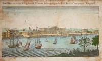
Fort William, in the Kingdon of Bengal, belonging to the East India Company of England.
by London Magazine:
- Used
- Condition
- Used
- Quantity Available
- 1
- Seller
-
London, United Kingdom
- Item Price
-
£100.00£5.95 shipping to USA
Show Details
Description:
London, 1754. Copper engraving, 11.5 x 19.5 cms, some spotting, recent hand-colour, blank verso; the old fort in Calcutta (the new one, begun by Clive, was finished in 1781); published in the London Magazine. Map
Item Price
£100.00
£5.95
shipping to USA

Gingee
by Orme, Robert:
- Used
- Condition
- Used
- Quantity Available
- 1
- Seller
-
London, United Kingdom
- Item Price
-
£75.00£5.95 shipping to USA
Show Details
Description:
London, c. 1780. Copper engraving, 29 x 39.5 cms, engraved by Thomas Kitchin, black and white as issued; prepared for Orme’s “A History of the Military Transactions of the British Nation in Indostan”, published in four editions between 1763-1799. Map
Item Price
£75.00
£5.95
shipping to USA

Didn’t find what you’re looking for?
Try adding this search to your want list. Millions of books are added to our site everyday and when we find one that matches your search, we’ll send you an email. Best of all, it’s free.
Add to Want List

Are you a frequent reader or book collector?
Join the Bibliophile's Club and save 10% on every purchase, every day — up to $20 savings per order!

Social Responsibility
Did you know that since 2004, Biblio has used its profits to build 16 public libraries in rural villages of South America?
