Description:
N.p. [Amsterdam]: N.p. [Blaeu], n.y. [1665]. 21½" X 17½" (image 20½" X 16"). Hand colored. Elaborately-colored insets featuring putti at both lower corners. This "Archdiocese of Zaragoza" ecclesiastical map of this region of Spain was owned by bestselling historical novelist KENNETH ROBERTS (1885-1957), author of "Northwest Passage" among other titles, who had a sizable map collection. In the lower left corner he inscribes this map "For Robert Oldmixon, with the / best wishes of Kenneth Roberts, 1957 / Done by / Blaeu, / 1665, / Amsterdam." The map has been beautifully and archivally double matted using 100% acid-free materials and framed under UV-filtering conservation glass (overall size 29" X 24").
Search Results: Maps from Main Street Fine Books & Manuscripts, ABAA
You searched for:
- Subject: Maps from Main Street Fine Books & Manuscripts, ABAA
Results 1 - 20 of 139

Arcobispado de Caragossa
by (ZARAGOZA -- Map)
- Used
- Condition
- Used
- Quantity Available
- 1
- Seller
-
Galena, Illinois, United States
- Item Price
-
£643.39£4.05 shipping to USA
Show Details
Item Price
£643.39
£4.05
shipping to USA
Stock Photo: Cover May Be Different
Atlas of the First World War
by GILBERT, Martin
- Used
- Hardcover
- first
- Condition
- Used
- Binding
- Hardcover
- ISBN 10 / ISBN 13
- 9780195210750 / 0195210751
- Quantity Available
- 1
- Seller
-
Galena, Illinois, United States
- Item Price
-
£36.42£4.05 shipping to USA
Show Details
Description:
New York: Oxford University Press, 1994. Hardcover. Small 4to. Blue cloth with gilt spien lettering, pictorial dust jacket. ix, 164pp, xvii-xxxii. Extensive maps. Fine/near fine. Circular ownership blind-emboss on front and rear flyleaves. Handsome first printing of the revised second edition of this history of WWI in maps, far superior to the 1974 first edition.
Item Price
£36.42
£4.05
shipping to USA

More Photos
Atlas of American Military History
by BRADFORD, James C. (editor)
- Used
- Hardcover
- first
- Condition
- Used
- Binding
- Hardcover
- Quantity Available
- 1
- Seller
-
Galena, Illinois, United States
- Item Price
-
£44.51£4.05 shipping to USA
Show Details
Description:
New York: Oxford University Press, 2003. Hardcover. 4to. Full brown leatherette with gilt lettering, rules and pictorial stamping 248pp. All edges gilt. Extensive color maps, illustrations, brown watered silk endpapers, sewn-in gold satin page marker. Near fine. Wonderfully tight and handsome first edition covering the early 16th century to the late 20th century.
Item Price
£44.51
£4.05
shipping to USA
Atlas of Delaware County Iowa: Containing Maps, Plats of the Townships, Rural Directory, Pictures of Farms & Families, Articles About History Etc.
- Used
- Paperback
- Condition
- Used
- Binding
- Paperback
- Quantity Available
- 1
- Seller
-
Galena, Illinois, United States
- Item Price
-
£32.37£4.05 shipping to USA
Show Details
Description:
Minneapolis: Title Atlas Company, 1979. Paperback. Folio. Stiff green leatherette wrappers with gilt lettering and stamping, spiralbound. (6pp), 16pp, (9pp), 55pp, (ca. 150pp). Extensive maps, illustrations, advertisements. Very good. Slightest bit of wear. Probable sole edition of this modern county atlas (Delaware County is en eastern central Iowa) durably bound in extra heavy duty metal spiral binding, thus fairly "tight" (can this be said of a spiral binding?), with no loosening pages. Surprisingly uncommon for so modern an atlas.
Item Price
£32.37
£4.05
shipping to USA
Atlas of Dubuque County Iowa: Containing Maps, Plats of the Townships, Rural Directory, Pictures of Farms & Families, Articles About History Etc.
- Used
- Paperback
- Condition
- Used
- Binding
- Paperback
- Quantity Available
- 1
- Seller
-
Galena, Illinois, United States
- Item Price
-
£32.37£4.05 shipping to USA
Show Details
Description:
Minneapolis: Title Atlas Company, 1979. Paperback. Folio. Stiff green leatherette wrappers with gilt lettering and stamping, spiralbound. (6pp), 60pp, (ca. 200pp). Extensive maps, illustrations, advertisements. Near fine. Probable sole edition of this modern county atlas durably bound in extra heavy duty metal spiral binding, thus "tight" (can this be said of a spiral binding?), with no loosening pages whatsoever. Surprisingly uncommon for so modern an atlas.
Item Price
£32.37
£4.05
shipping to USA
Atlas of Tama County Iowa Containing Maps of Townships of the County...
by (TAMA COUNTY, IOWA)
- Used
- Hardcover
- first
- Condition
- Used
- Binding
- Hardcover
- Quantity Available
- 1
- Seller
-
Galena, Illinois, United States
- Item Price
-
£60.70£4.05 shipping to USA
Show Details
Description:
Des Moines: The Anderson Publishing Co, 1926. Hardcover. Folio. Burgundy blind-embossed leatherette. 43pp, (3pp ads), (2pp), 122pp, xxi. Extensive full-page color maps, illustrations. Good plus overall. Mild binding edgewear, with spine a bit rough (mainly at head/tail); inner hinges strengthened with old but neat and expert black cloth reinforcement; front flyleaf outer edge worn but expertly, archivally mended, with rest of text block tight and nice. Fairly attractive and handlable atlas of this small east central Iowa county whose county seat is Toledo. Numerous large, detailed township maps all bright and lovely. First quarter consists of the Marshall County atlas, the remainder (called "Volume II") an "Atlas of the World (Latest Federal Census Edition)... Profusely Illustrated by George Wharton James and Alan H. Burgoyne." These relatively recent county atlases are rather uncommon and difficult to find in decent condition.
Item Price
£60.70
£4.05
shipping to USA
Atlas of Ancient Archaeology
by HAWKES, Jacquetta (editor)
- Used
- Hardcover
- Condition
- Used
- Binding
- Hardcover
- Quantity Available
- 1
- Seller
-
Galena, Illinois, United States
- Item Price
-
£40.46£4.05 shipping to USA
Show Details
Description:
New York: McGraw-Hill Book Company, 1975. Hardcover. 4to. Green cloth with gilt spine lettering, pictorial dust jacket. 272pp. Extensive maps and floor plans, line drawings. Fine/near fine. Tight, handsome second U.S. printing of this exceptionally useful reference, first published 1974.
Item Price
£40.46
£4.05
shipping to USA

Atlas of Medieval Europe
by MacKAY, Angus, and DITCHBURN, David (editors)
- Used
- Hardcover
- first
- Condition
- Used
- Binding
- Hardcover
- ISBN 10 / ISBN 13
- 9780415019231 / 0415019230
- Quantity Available
- 1
- Seller
-
Galena, Illinois, United States
- Item Price
-
£44.51£4.05 shipping to USA
Show Details
Description:
London: Routledge, 1997. Hardcover. Small 4to. Black cloth with silver spine lettering, pictorial dust jacket. ix, 271pp. Extensive maps, decorative endpapers. Fine/fine.Circular blind-embossed ownership imprint on half-title page. Pristine first edition of this important and fascinating reference "filled with over 140 maps and commentaries" -- to cite front flap copy -- "detailing the whole of the medieval period from the latter days of Rome through to the beginnings of the early modern world." Concludes with an outstanding bibliography.
Item Price
£44.51
£4.05
shipping to USA

An Atlas of Current Affairs
by HORRABIN, J.F.
- Used
- Hardcover
- first
- Condition
- Used
- Binding
- Hardcover
- Quantity Available
- 1
- Seller
-
Galena, Illinois, United States
- Item Price
-
£60.70£4.05 shipping to USA
Show Details
Description:
New York: Alfred A. Knopf, 1934. Hardcover. Small 8vo. Black cloth with green lettering, pictorial dust jacket. x, 149pp, iv. 74 full-page maps. Very good/good plus. Binding a tad spotted, else internally tight and near fine; jacket quite rubbed and edgeworn, with paper loss to lower half of spine. Tight, fairly nice first U.S. edition of this delightful period piece chock full of pre-WW2 world maps and facing them explanations of how and why the borders are what they are. Particularly fascinating and timely is, in "The Americas" section, "The Negro Problem in the United States." Scarce.
Item Price
£60.70
£4.05
shipping to USA
BOAC Atlas
by (BRITISH OVERSEAS AIRWAYS CORPORATION)
- Used
- Hardcover
- Condition
- Used
- Binding
- Hardcover
- Quantity Available
- 1
- Seller
-
Galena, Illinois, United States
- Item Price
-
£76.88£4.05 shipping to USA
Show Details
Description:
London: British Overseas Airways Corporation, n.y.. Hardcover. Small 8vo. Blue cloth with gilt lettering, dust jacket. (Ca. 100pp), 24pp. Extensive color maps. Near fine/very good. Mild jacket wear, mainly a slightly age-toned spine with chips at head and tail. Probable first and sole edition. Handsome and tight world atlas published by the British state-owned airline, which in 1974 became British Airways. Undated, but seemingly of 1950s vintage, this diminutive atlas demonstrates that as one leaf advertises "BOAC Flies to All Six Continents," and its many excellent maps all show flight routes. Scarce, especially in the dust jacket.
Item Price
£76.88
£4.05
shipping to USA
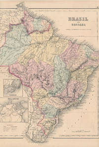
Brazil and Guayana
by (BRAZIL, GUAYANA -- Map)
- Used
- Condition
- Used
- Quantity Available
- 1
- Seller
-
Galena, Illinois, United States
- Item Price
-
£76.88£4.05 shipping to USA
Show Details
Description:
New York: J.H. Colton & Co, 1855. 13 3/4" X 16½" (image 13¼" X 16¼"). Hand colored. Near fine. Faint age toning. A beauty, clean margined and striking. Small insets at lower left showing "Pernambuco" and "Rio de Janeiro." Full text ("The Republic of Chili") on verso.
Item Price
£76.88
£4.05
shipping to USA
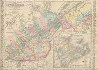
Canada East Formerly Lower Canada
by (CANADA EAST -- Map)
- Used
- Condition
- Used
- Quantity Available
- 1
- Seller
-
Galena, Illinois, United States
- Item Price
-
£76.88£4.05 shipping to USA
Show Details
Description:
Philadelphia: Charles Desilver, 1856. 17¼" X 13 3/4" (image 15½" X 12¼"). Hand colored. Very good. Light foxing and age toning. Quite clean and lovely example, with sharp decorative border and large inset at lower right showing "Novia Scotia New Brunswick &c.
Item Price
£76.88
£4.05
shipping to USA
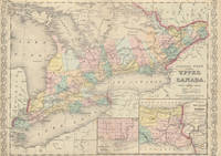
Canada West Formerly Upper Canada
by (CANADA WEST -- Map)
- Used
- Condition
- Used
- Quantity Available
- 1
- Seller
-
Galena, Illinois, United States
- Item Price
-
£60.70£4.05 shipping to USA
Show Details
Description:
Desilver. Philadelphia: Charles Desilver, 1856. 17¼" X 13 3/4" (image 15 3/4" X 12½"). Hand colored. Ornamental border. Inset map of the city of Toronto and environs and of the vicinity of Niagara Falls. Very good. Moderate foxing.
Item Price
£60.70
£4.05
shipping to USA

Central America
by (CENTRAL AMERICA -- Map)
- Used
- Condition
- Used
- Quantity Available
- 1
- Seller
-
Galena, Illinois, United States
- Item Price
-
£101.16£4.05 shipping to USA
Show Details
Description:
New York: J.H. Colton & Co, 1855. 16½" X 13½" (image 15" X 11 3/4"). Hand colored. Very good. Mild age toning; minor discoloration along edges (not touching image). Nicely colored example, featuring three insets at lower left showing "Isthmus of Panama," "Harbor of San Juan de Nicaragua" and "The 'Nicaragua Route'" and two at center right showing "Aspinwall City" and "City of Panama.
Item Price
£101.16
£4.05
shipping to USA

Chicago
by (CHICAGO, ILLINOIS -- Map)
- Used
- Condition
- Used
- Quantity Available
- 1
- Seller
-
Galena, Illinois, United States
- Item Price
-
£76.88£4.05 shipping to USA
Show Details
Description:
N.p.: N.p., n.y. [ca. 1890s?]. 10½" X 13". Very good. Slight bit of edgewear, with quite small loss of coated surface (only) at upper right and lower right corners, not affecting image and touching upon outermost printed border at upper corner only. Printed entirely in black on heavy orange coated stock, with lake and major thoroughfares accented in green. Titled simply "Chicago" at upper right, with "Reference to Figures" in fine print below and two small columns below this itemizing "Depots" (22 stops) and "Some of the Principal Hotels" (12 locations). "Steam Roads" and "Horse Roads" are also identified. Attractive if cryptic -- possibly printed by George F. Cram for one of the many editions of his "Universal Atlas" or "Unrivaled Atlas of the World," for the similarities are striking.
Item Price
£76.88
£4.05
shipping to USA

Chili, Argentine Republic, Paraguay and Uruguay
by (CHILE, ARGENTINE REPUBLIC, PARAGUAY, URUGUAY -- Map)
- Used
- Condition
- Used
- Quantity Available
- 1
- Seller
-
Galena, Illinois, United States
- Item Price
-
£52.60£4.05 shipping to USA
Show Details
Description:
Philadelphia: Charles Desilver, 1856. 13 3/4" X 17¼" (image 12½" X 15"). Hand colored. Very good. Unfortunate but not terribly disfiguring discoloration at upper right corner (touching image slightly). Clear, colorful map. Nice, brightly colored example with interesting small inset at lower right showing "South Part of Patagonia." Sharp decorative border.
Item Price
£52.60
£4.05
shipping to USA
Civil War Newspaper Maps: A Historical Atlas
by BOSSE, David
- Used
- Hardcover
- first
- Condition
- Used
- Binding
- Hardcover
- ISBN 10 / ISBN 13
- 9780801845536 / 080184553X
- Quantity Available
- 1
- Seller
-
Galena, Illinois, United States
- Item Price
-
£24.28£4.05 shipping to USA
Show Details
Description:
Baltimore: The Johns Hopkins University Press, 1993. Hardcover. 4to. Blue cloth, pictorial dust jacket. x, 162pp. Numerous illustrations, map endpapers. Near fine/near fine. A tight and handsome first edition of this useful reference.
Item Price
£24.28
£4.05
shipping to USA

Collection of 14 company Christmas cards
by (RAND McNALLY & COMPANY / CARTOGRAPHY / CHRISTMAS CARDS)
- Used
- Condition
- Used
- Quantity Available
- 1
- Seller
-
Galena, Illinois, United States
- Item Price
-
£141.63£4.05 shipping to USA
Show Details
Description:
Chicago: Rand McNally & Company, 1972. Collection of 14 company Christmas cards, one each for the years 1972 through 1985 plus year three undated. Near fine overall. Printed in modest quantities and intended for distribution only to top vendors, suppliers and distributors, this delightful collection ranges in size from narrow 4to to wide 8vo, some bigger and some smaller. All are handsomely and colorfully printed on fine heavy stock. Most are at least three panels and many are more, and all open up to reveal superb reproductions of famed antiquarian maps from around the world. Some open up to small poster size, and two contain separate folded maps that open to full poster size. Several have been signed by various company executives. Most unusual and attractive -- a collection that would be near-impossible to duplicate.
Item Price
£141.63
£4.05
shipping to USA
Commemorative Map: Campaigns of the Civil War -- Centennial Edition
by (CIVIL WAR / MAP)
- Used
- Signed
- Condition
- Used
- Quantity Available
- 1
- Seller
-
Galena, Illinois, United States
- Item Price
-
£40.46£4.05 shipping to USA
Show Details
Description:
Maplewood, NJ: C.S. Hammond & Co, 1963. Small 4to (folded, as issued) -- opens to 38" x 26". Heavy glossy stock. Near fine. Superb, bright map from this American map producer -- other than original folds (none weakened), as pristine as it gets. An appealing, information-packed, full color map of the eastern third of the U.S., featuring pictorial representations of the major battles and accompanying texts, color arrows highlighting major troop movements, etc. -- and about the border portraits of the major Union and Confederate generals, the major flags for each side, etc. At lower right it's noted "Published in co-operation with the Civil War Centennial Commission" and bearing the printed signature of that august organization's executive director, Karl S. Betts. Interestingly, accompanying this map is a Typed Letter Signed from Betts, 1p, 8" X 11", Washington, DC, 2 June 1960. Addressed to Arnold Gates (1914-93), noted Lincoln/Civil War scholar. Near fine. On…
Read More Item Price
£40.46
£4.05
shipping to USA
More Photos
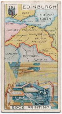
Counties and Industries
by (CIGARETTE CARDS -- BRITISH)
- Used
- Condition
- Used
- Quantity Available
- 1
- Seller
-
Galena, Illinois, United States
- Item Price
-
£76.88£4.05 shipping to USA
Show Details
Description:
Nottingham, England: John Player & Sons, n.y.. Full set of 25 numbered cigarette cards, undated but published in 1914. Heavy stock 1 3/8" X 2 5/8". Very good to near fine. Mild occasional edgewear, but overall bright and quite handsome. An attractive complete set of these brightly colored pictorial cards celebrating 25 of England's counties and a prime industry from each, with a county map filling the upper half of each and an industry the lower half. Scenes consist of, in numerical order: 1. North wales -- Slate Quarrying, 2. Monmouthshire -- Iron and Coal, 3. Northumberland -- Shipbuilding, 4. Perthshire -- Dry Cleaning, 5. Kent -- Hop Picking, 6. Munster -- Butter Making, 7. Lincolnshire -- Agriculture, 8. Lancashire -- Cotton Spinning, 9. Northampton -- Boot Making, 10. Staffordshire -- Pottery, 11. Bedfordshire -- Straw Hat Making, 12. Connaught -- Horse Breeding, 13. Roxburghshire -- Woollen Manufacture, 14. Devonshire -- Dairy Produce, 15. Edinburgh -- Book Printing, 16. South Wales -- Coal…
Read More Item Price
£76.88
£4.05
shipping to USA

Didn’t find what you’re looking for?
Try adding this search to your want list. Millions of books are added to our site everyday and when we find one that matches your search, we’ll send you an email. Best of all, it’s free.
Add to Want List

Are you a frequent reader or book collector?
Join the Bibliophile's Club and save 10% on every purchase, every day — up to $20 savings per order!

Social Responsibility
Did you know that since 2004, Biblio has used its profits to build 16 public libraries in rural villages of South America?
