Description:
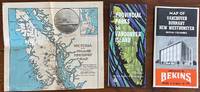
1977. No binding. Very Good. 1) Victoria and Island Touring Map. Circa 1925. Scarce. Victoria and Island Publicity Bureau (Publisher) Colonist Lithograph (Printer). Quite scarce promotional map, showing the roads and cruise ship lines in and around the Vancouver Island area. Promotional advertising on the verso. Shows major highways and ferry routes on Vancouver Island, lower mainland B.C., and Washington state. Inset shows detail of Victoria and the Saanich Peninsula. Inset on verso shows major highways along coastal Washington, Oregon, and northern California. Also on verso: "Victoria : the outstanding capital city of British Columbia." Folded Size: 5-1/2 x 5-1/4 inchesFlat size: 11 x 19 inches 2) Provincial Parks on Vancouver Island [1977] ScarceFolded Size: 4 x 9 inchesFlat size: 27-3/4 x 18 inchesFree tourist brochure by Ministry of Lands, Parks, and HousingIncludes Gulf IslandsVancouver Island large full page map image with Vancouver Island Facts textThe reverse of the map is filled with…
Read More Search Results: Maps from Lord Durham Rare Books (IOBA)
You searched for:
- Subject: Maps from Lord Durham Rare Books (IOBA)
Results 1 - 20 of 26
More Photos
3 Vancouver, Victoria BC related maps
by Various
- Used
- very good
- Condition
- Used - Very Good
- Quantity Available
- 1
- Seller
-
St. Catharines, Ontario, Canada
- Item Price
-
£81.64£20.41 shipping to USA
Show Details
Item Price
£81.64
£20.41
shipping to USA

More Photos
Atlas du traité de grandes opérations militaires, par le colonel Jomini, employé de Sa Majesté l'Empereur Napoléon
by JOMINI, Antoine Henri, baron de (1779-1869)
- Used
- Condition
- Used - Good-
- Edition
- 1st Edition
- Quantity Available
- 1
- Seller
-
St. Catharines, Ontario, Canada
- Item Price
-
£102.05£20.41 shipping to USA
Show Details
Description:
Paris: Giguet et Michaud, 1807. 1st Edition. Hard Cover. Good-. ATLAS OF THE TREATY OF MAJOR MILITARY OPERATIONS BY COLONEL JOMINI First edition. 8 x 10⁻¹/2 inches. With large engraved 'Carte Generale Pour l'Intelligence de la Guerre de Sept-Ans' and related Battle Plans for Lowositz, Prague, Kollin, Roisbach, Breslau, lagemdorf, Leuthen, Zomdorf, Hohenkirch, Cunersdorf, Minden, Zullichau, Maxen, Landshut, Lignitz, Torgau, Reichenbach, Freyberg (lacking Plate XIII --Battle of Krefeld). (19 of 20 plates, virtually all folding). Comtemporary worn leather spine and leather label with gilt type and 5 gilt stars and double rules. Paper covered boards with worn edges, cover is in fair condition and needs rebinding. Internally one map, #6, has a 2" border tear with 1 inch going into map, a few maps with light foxing on outside borders, otherwise the engravings are very good, fresh, dark impressions. Third part of his books on the wars of Frederick II. The fourth part will be published in 1809 under the…
Read More Item Price
£102.05
£20.41
shipping to USA

Braddock's defeat Field of Battle 1755
by SHAFFNER, Taliaferro Preston (1818-1881)
- Used
- very good
- Condition
- Used - Very Good
- Quantity Available
- 1
- Seller
-
St. Catharines, Ontario, Canada
- Item Price
-
£12.25£20.41 shipping to USA
Show Details
Description:
1863. No binding. Very Good. Braddock's field of battle plan British defeat near Fort Du Quesne. Image 9 x 5.5 inches (23x14cm). Steel engraving. Very good condition. from Taliaferro Preston Shaffner's History of the United States, Plate V Drawn and engraved for 'Shaffner's History of the United States' by W.W. Woolley. Circa 1863.
Item Price
£12.25
£20.41
shipping to USA

More Photos
Carte de la Riviere de Richelieu et du Lac Champlain
by BELLIN, Jacques Nicolas [1703-1772] (cartographer)
- Used
- good
- Condition
- Used - Good
- Edition
- 1st Edition
- Quantity Available
- 1
- Seller
-
St. Catharines, Ontario, Canada
- Item Price
-
£102.05£20.41 shipping to USA
Show Details
Description:
[Paris], 1744. 1st Edition. No binding. Good. First Edition. Paper flat size: 5-5/8 x 7-3/4 inches to the neat-line with right border having #7 sideways. Was folded, now flat and has been cleaned and deacidified, with 1/4 x 3-3/4 inch top right border lacking, otherwise, good condition. Engraver Desbruslins stated.Copper engraved map of the Richelieu River, Lake Champlain and Lake George, with a portion of the St. Lawrence River. Lake George is called Lac du S. Sacrament, and it has an odd, round second lake above it. The English renamed the lake after King George II in 1755. This waterway was an important route between Montreal and the Hudson River, and it was important tactically during the French and Indian War.Tooley, (MCC 96) #695 The map was produced for Charlevoix's 1744 Histoire et description générale de la Nouvelle France.Jacques Nicolas Bellin was one of the most important and proficient French cartographers of the mid-eighteenth century. He was appointed the first Ingenieur Hydrographe…
Read More Item Price
£102.05
£20.41
shipping to USA

More Photos
Carte des Bayes, Rades et Port de Plaisance dans l'Ile de Terre Neuve
by BELLIN, Jacques Nicolas [1703-1772] (cartographer) & DHEULLAND, Guillaume [1700-1770] (engraved by)
- Used
- good
- Condition
- Used - Good
- Edition
- 1st Edition
- Quantity Available
- 1
- Seller
-
St. Catharines, Ontario, Canada
- Item Price
-
£81.64£20.41 shipping to USA
Show Details
Description:
[Paris], 1744. 1st Edition. No binding. Good. First edition. Map of the Bay, Harbour and Port of Placentia on the Island of Newfoundland.Paper flat size: 11-1/4 x 7-3/4 inches to the neat-line with right border having #2 sideways. Was folded, now flat and has been cleaned and deacidified, with some very light offsetting on the bottom and 3/8 x 5 inch top left border lacking, old holes in bottom order repaired, otherwise, good condition. Engraved by Dheulland. The map was produced for Charlevoix's 1744 Histoire et description générale de la Nouvelle France.Jacques Nicolas Bellin was one of the most important and proficient French cartographers of the mid-eighteenth century. He was appointed the first Ingenieur Hydrographe de la Marine, and also Official Hydrographer to the French King.Guillaume Dheulland was a French master engraver and draughtsman was most known for his large Plan of Paris in 1756. He also engraved for famous cartographers such as Charlevoix, Bellin, Cassini and Prevost.
Item Price
£81.64
£20.41
shipping to USA

More Photos
Carte de la Baye de Hudson. Par N. Bellin Ingenieur de la Marine
by BELLIN, Jacques Nicolas [1703-1772] (cartographer)
- Used
- good
- Condition
- Used - Good
- Edition
- 1st Edition
- Quantity Available
- 1
- Seller
-
St. Catharines, Ontario, Canada
- Item Price
-
£77.56£20.41 shipping to USA
Show Details
Description:
[Paris], 1744. 1st Edition. No binding. Good. First Edition. Paper flat size: 11-1/2 x 8-1/4 inches to the neat-line with right border having #3 sideways. Was folded, now flat and has been cleaned and deacidified, with 1/2 x 4-1/4 inch top left border lacking, four very small hole on bottom border repaired, otherwise, good condition. Engraved by Dheulland.Kershaw II, 423, p.81 The map was produced for Charlevoix's 1744 Histoire et description générale de la Nouvelle France.Jacques Nicolas Bellin was one of the most important and proficient French cartographers of the mid-eighteenth century. He was appointed the first Ingenieur Hydrographe de la Marine, and also Official Hydrographer to the French King.Guillaume Dheulland was a French master engraver and draughtsman was most known for his large Plan of Paris in 1756. He also engraved for famous cartographers such as Charlevoix, Bellin, Cassini and Prevost.
Item Price
£77.56
£20.41
shipping to USA

More Photos
Carte de la Partie Orientale de la Nouvelle France ou du Canada
by BELLIN, Jacques Nicolas [1703-1772]
- Used
- good
- Condition
- Used - Good
- Edition
- 1st Edition
- Quantity Available
- 1
- Seller
-
St. Catharines, Ontario, Canada
- Item Price
-
£489.84£20.41 shipping to USA
Show Details
Description:
[Paris], 1744. 1st Edition. No binding. Good. SCARCE AND IMPORTANT PRE-FRENCH & INDIAN WAR MAP First edition. Scarce pre-French & Indian War map of Canada, from Newfoundland to Lake Ontario and including the Northern portion of New England. Size to neat-line: 22-1/4 x 16-1/2 inches. 35 rotted on it's side on the left side border outside the neat line confirming it is a first edition in good condition. "Debruslins Sculpsit" engraved below the neat-line at the bottom right.Reference: Kershaw 490. "of particular interest to Bellin's first state of the map in 1744, are some of the notations that adorn the map and inform the viewer. Bellin notes that this map is extremely different to all other maps that would have preceded it because of his access to manuscript material in the Dépôt des Carte, Plans et Journaux de la Marine as well as from firsthand accounts form Jesuit missionaries. In other words, Bellin, who sorted and compiled works from various sources, was better known as a "géographe de…
Read More Item Price
£489.84
£20.41
shipping to USA

More Photos
Carte du fonds de la Baye de Hudson, que les Anglois appellent Baye James
by BELLIN, Jacques Nicolas [1703-1772] (cartographer)
- Used
- good
- Condition
- Used - Good
- Edition
- 1st Edition
- Quantity Available
- 1
- Seller
-
St. Catharines, Ontario, Canada
- Item Price
-
£81.64£20.41 shipping to USA
Show Details
Description:
[Paris], 1744. 1st Edition. No binding. Good. First Edition. Paper flat size: 5-5/8 x 7-3/4 inches to the neat-line with right border having #38 sideways. Was folded, now flat and has been cleaned and deacidified, with 1/4 x 3-3/4 inch top right border lacking, otherwise, good condition. Engraver Desbruslins stated.Copper engraved map. Covers area of James Bay, the southern appendage of Hudson's Bay, with Fort Rupert and the other rivers entering it. Scale 1:3,400,000 Echelle de Lieues Marines de France. The map was produced for Charlevoix's 1744 Histoire et description générale de la Nouvelle France.Jacques Nicolas Bellin was one of the most important and proficient French cartographers of the mid-eighteenth century. He was appointed the first Ingenieur Hydrographe de la Marine, and also Official Hydrographer to the French King.Desbruslins active 18th century, engraver.
Item Price
£81.64
£20.41
shipping to USA

More Photos
Carte du Golphe de St-Laurent et Pays voisins pour servir à l'Histoire Générale des Voyages
by BELLIN, Jacques Nicolas [1703-1772]
- Used
- good
- Condition
- Used - Good
- Edition
- 1st, 2nd issue
- Quantity Available
- 1
- Seller
-
St. Catharines, Ontario, Canada
- Item Price
-
£81.64£20.41 shipping to USA
Show Details
Description:
France: (Histoire des Voyages), 1780. 1st, 2nd issue. No binding. Good. First edition, 2nd state. Paper size: 15-1/2 x 10 inches Image size: 14-1/4 x 8-3/4 inches. Copper-engraved map, hand colouring in outline. Gulf of Saint Lawrence area. Hand colored antique map of the Gulf of Saint Lawrence showing is the outlet of North America's Great Lakes via the Saint Lawrence river into the Atlantic Ocean. Gulf of Saint Lawrence / Newfoundland / Cape Breton / Anticosti / Prince Edward Island. Attractive cartouche. All copy in French.Two fold lines but otherwise in good condition. Plate nos. lower left and right: Tom XIII in 4°. No. 2; Tome 14 in 8°. First state is 1757 but this second state is circa 1780. (Kershaw, #590, p.218).
Item Price
£81.64
£20.41
shipping to USA

More Photos
Carte du Detroit entre le Lac Superieur et le Lac Huron, ave le Sault Sainte Marie et la Poste de Michillimakinac, Dresse sur les Manuscrits du Depot des Cartes et Plans de la Marine
by BELLIN, Jacques Nicolas [1703-1772] & DHEULLAND, Guillaume [1700-1770] (engraved by)
- Used
- good
- Condition
- Used - Good
- Edition
- 1st Edition
- Quantity Available
- 1
- Seller
-
St. Catharines, Ontario, Canada
- Item Price
-
£97.97£20.41 shipping to USA
Show Details
Description:
Paris: Chez Rolin, 1744. 1st Edition. No binding. Good. First edition. Copper engraved map. Image size to neat line: 6-1/4 x 8-7/8 inches. Small map of the strategic passage in the Upper Lakes system, which was so important to the colonial fur trade. Map details the region between Lake Superior and Lake Huron. Starting at Whitefish Bay & Point, the map locates Sault Ste Marie & the course of the St Mary's River down to Isle St. Joseph showing the portage & mission of Ste Marie, Fort Sauvage & Isle St. Georges.Shows the Passage des Canots (canoes) and Passage des Batimens (ships) on either side of Isle St.Joseph. Chart also depicts the Straits of Mackinac with the Bay and Cape of St. Ignace on the northern shore. Isle St.Helene in center of the straits and a fort & mission of St. Ignace on the southern shore. Also shows the Isle Ronde, I aux Bois Blancs. I.Michillimakinac, Isle du Detour and Isle de Tessalons. Includes a decorative compass rose. Engraver's imprint, Desbruslins Sculpsit at lower…
Read More Item Price
£97.97
£20.41
shipping to USA

More Photos
Chart of the World showing New Route through Canada between England, China, Japan, Australasia and the East
by JOHNSON, J. (John) & JOHNSON, George (1837-1911)
- Used
- Condition
- Used
- Edition
- 1st Edition
- Quantity Available
- 1
- Seller
-
St. Catharines, Ontario, Canada
- Item Price
-
£81.64£20.41 shipping to USA
Show Details
Description:
[Ottawa]: Department of Agriculture, Canada Bank Note, 1886. 1st Edition. No binding. Fair. First edition. 46-1/2 x 28 inches unfolded.. Now folded with many closed tears from folds, recent scotch tape in the back on a few joints. Fair condition. Published by order of the Hon. John Carling, M.P., Minister of Agriculture. Department of Agriculture, Ottawa, Canada, April 1886. Scarce and interesting map showing Canada as the center of the World!Map of transport within Canada and between Canada and other countries. Railway transport shown within Canada and to the United States. Ship lines to Japan, China, Australia, New Zealand and the United Kingdom are shown with hashed red lines. Major cities are labelled and British possessions are coloured red. Relief shown with hachures. .
Item Price
£81.64
£20.41
shipping to USA

More Photos
Geographical, Statistical, And Historical Map Of Upper And Lower Canada, And The Other British Possessions In North America. British Possessions In North America
by LUCAS, Fielding Jr. [1781-1854] & YOUNG & DELLEKER
- Used
- very good
- Condition
- Used - Very Good
- Quantity Available
- 1
- Seller
-
St. Catharines, Ontario, Canada
- Item Price
-
£61.23£20.41 shipping to USA
Show Details
Description:
Philadelphia: H.C. Carey & I. Lea, 1823. No binding. Very Good. Paper size 17.5 x 22 wide, text & image size 16-1/2 x 20-1/4 inches and actual map image size (map border) : 9-1/4 x 13-1/2 inches. Hand-colored map surrounded by statistical data, 'Geographical, Statistical and Historical Map of Upper and Lower Canada, and the Other British Possessions in North America.' Originally issued as folded now flat with the fold slightly covering the p in map and the s in possessions in the top heading. Small gray mark in in border next to "commerce" text on bottom left. Overall condition is very good other than noted above. Map and references for the British Empire in Canada, from Carey and Lea's 'A Complete Historical, Chronological, and Geographical American Atlas. The map extends from Newfoundland in the east to Lake of the Woods in the west; a very vibrant, strong impression. The text describes Lower Canada, Upper Canada, Nova Scotia and New Brunswick. With text below map and at both sides, pertaining to…
Read More Item Price
£61.23
£20.41
shipping to USA

More Photos
Isles de la Reine Charlotte - map of Queen Charlotte Island on James Cook journey
by BELLIN, Jacques Nicolas [1703-1772]
- Used
- very good
- Condition
- Used - Very Good
- Quantity Available
- 1
- Seller
-
St. Catharines, Ontario, Canada
- Item Price
-
£28.57£20.41 shipping to USA
Show Details
Description:
1785. No binding. Very Good. 40 X 23cm (16" X 9 1/2"), Folded (as issued) Some age toning, small old water stain marks along top 2 inches and foldings from the book. Good condition.Tilted "Isles de la reine charlotte. Der Konigin Charlotte Inseln" Jacques Nicolas Bellin was a French hydrographer, geographer, and member of the French intellectual group called the philosophes.
Item Price
£28.57
£20.41
shipping to USA

More Photos
Map of Nova Scotia, New Brunswick Cape Breton Island and Prince Edward Island in Counties
by MITCHELL, Samuel Augustus Jr. (1792-1868)
- Used
- very good
- Condition
- Used - Very Good
- Edition
- 1st
- Quantity Available
- 1
- Seller
-
St. Catharines, Ontario, Canada
- Item Price
-
£40.82£20.41 shipping to USA
Show Details
Description:
Philadelphia: S. Augustus Mitchell, Jr., 1868. 1st. No binding. Very Good. First US edition. Measurement with Vine Border: 270 x 340 mm (10-5/8 x 13-3/8 inches) (Plus Margin). Copyright Date in Lower Margin: 1867.The reverse side of the map is blank. The map's corner is printed with the altas page number 5. With an inset map of Halifax on bottom rightCounties, cities, towns, lakes, rivers, mountains, and transportation routes are shown.Beautifully engraved hand-coloured map with two 1/2 inch open tears on right border, otherwise, in very good condition. The map was created and copyright in 1867, the same year present-day Canada was created, when the British North American Act united Ontario, Quebec, Nova Scotia and New Brunswick in the Dominion of Canada. This map was then published in Philadelphia one year later, in 1868, in the atlas titled "Mitchell's New General Atlas Showing Maps of the Various Counturies of the World, Plans of Cities, etc".Samuel Augustus Mitchell (1792-1868) been…
Read More Item Price
£40.82
£20.41
shipping to USA

More Photos
Map of part of Labrador illustrating the proposed northern boundary of the Province of Quebec
by LOW, A. P. (Albert Peter), [1861-1942] contributor & MCGEE, John J. (John Joseph), [1845-1927]
- Used
- good
- Condition
- Used - Good
- Edition
- 1st Edition
- Quantity Available
- 1
- Seller
-
St. Catharines, Ontario, Canada
- Item Price
-
£367.38£20.41 shipping to USA
Show Details
Description:
[Ottawa]: Department of Interior, Lithographic Office (A. P. Low, Surveyor, D. E. V Eaton, Cart.), 1896. 1st Edition. No binding. Good. SCARCE AND IMPORTANT QUEBEC & LABRADOR COLOURED MAP First edition. 29,3 x 90,7 cm on a folded sheet of 17 x 39 inches. Bar scale in miles. Shows rivers and lakes, trails, some geographical names between James Bay and the coast in a narrow band along the border. The proposed boundary is shown in red. "From A.P. Low's map of Labrador" (lower left corner). Scale 41 miles to one inch.Was separated at some folds now repaired with "Iwani Natural" Japanese tissue, two 1-1/2 inch tear in left top and left borders, otherwise, in good condition.Very scarce and important colour map created by order of the Clerk of the Privy Council John Jos. McGee to establish the Dominion's position. Note - "Dependency of Labrador". Map of part of Labrador illustrating the proposed Northern Boundary of the province of Quebec "To accompany the report of the Deputy Minister of the Interior,…
Read More Item Price
£367.38
£20.41
shipping to USA

More Photos
A Map of the Province of Upper Canada
by WYLD, James (1790-1836)
- Used
- very good
- Condition
- Used - Very Good
- Edition
- 5th Edition
- Quantity Available
- 1
- Seller
-
St. Catharines, Ontario, Canada
- Item Price
-
£775.58£20.41 shipping to USA
Show Details
Description:
London: Published by Jas. Wyld, Geographer to His Majesty. Charing Cross East, 1835. 5th Edition. Slip case. Very Good. QUITE SCARCE 1835 (5TH STATE] EDITION OF THIS UPPER CANADA MAP Linen-backed and folding wall map. Full title: A Map of the Province of Upper Canada, describing all the New Settlements, Townships, &c. with the Countries Adjacent from Quebec to Lake Huron, compiled from original documents in the Surveyor General's Office.Binding: Folded and housed in the publisher's original cloth case 4-5/8 x 8-1/4 inches with paper labels. Folded linen-backed map: Flat; 36 x 23-1/4 x 23-1/2 inches. Folded; 5-1/8 x 8 inches. Very good conditionWinearls, 30.5 First issued in 1800 by Smyth and subsequently revised by Wyld, this map of Upper Canada contains detailed information on the counties, districts, townships, transportation systems, place-names and northern Ontario ('Great Tract of Wilderness') &c. It also includes portions of Quebec, Michigan Territory, New York, Pennsylvania. Much of the…
Read More Item Price
£775.58
£20.41
shipping to USA

More Photos
Maps, Reports, Estimates &c, relative to Improvements of the Navigation of the River St. Lawrence and a proposed Canal connecting the River St. Lawrence and Lake Champlain. Laid before the Legislative Assembly during the 2nd Session, 5th Parliament, 1856
by CHABOT, Jean (1806-1860)
- Used
- very good
- Condition
- Used - Very Good
- Edition
- 1st Edition
- Quantity Available
- 1
- Seller
-
St. Catharines, Ontario, Canada
- Item Price
-
£326.56£20.41 shipping to USA
Show Details
Description:
Toronto: Published by John Lovell, 1856. 1st Edition. Hard Cover. Very Good. First edition, scarce. 20 x 14 in. 40 pages. Original leather spine and corners with gilt type on worn cloth cover. Inside pages are in very good condition with small pin holes old library name O.F.M. Québec on three of the 40 text pages. With a folding table and 7 folding maps on 6 sheets (with one extra map not called for on the ‘Maps Accompany this Report') Six long folding map pages are generally very good condition with some wear. Contains the following maps: #1.- Surveys of the Principal Rapids of the River St. Lawrence between Prescott and Lake St. Louis... DIVISION 3. from Lake St. Francis to Pointe au Diable comprsing the Coteau Rapids. (colour) 41 x 19-3/4 inches.#2.- Survey of the Rapids of the River St. Lawrence between Prescott and Lake St. Louis... DIVISION 4 from Pointe au Diable to Pointe au Moulin comprising the Cedar Rapids. (some colour) 60-1/2 x 19-3/4 inches.#3.- Survey of the Rapids of the River St.…
Read More Item Price
£326.56
£20.41
shipping to USA

More Photos
A New Chart of the River St. Lawrence from the island of Anticosti to Lake Ontario
by BELL, Andrew (1726-1809)
- Used
- good
- Condition
- Used - Good
- Edition
- 1st
- Quantity Available
- 1
- Seller
-
St. Catharines, Ontario, Canada
- Item Price
-
£102.05£20.41 shipping to USA
Show Details
Description:
[Edinburg]: [Scots Magazine Sept. 1759], 1759. 1st. No binding. Good. QUITE SCARCE EDINBURG SEPTEMBER 1759 EDITION OF ST. LAWRENCE[1759]. Copper plate engraving. 7.5 x 10 inches. Was folded, now flat. Some small markings outside of border otherwise good condition.Map maker: Andrew Bell Sculpt: A. Bell In addition to the main map, which traces the river from Anticosti Island to the city of Quebec, there is an included extension, A Continuation of the River St. Lawrence from Quebec to Lake Ontario. There are three additional insets: one focusing on the Bay of the Seven Isles, another on Lake Champlain, and The Traverse or Passage from Cape Torment into the South Channel of Orleans Isle. The river is filled with soundings, anchorages, shoals, rocks, and islands. This is the region where the epic Battle of the Plains of Abraham (Battle of Quebec) was fought in Canada during the French & Indian War. Nice map of the French & Indian War region where the major battle of the War, the Taking of Québec was…
Read More Item Price
£102.05
£20.41
shipping to USA

More Photos
Ontario Kingston Sheet 10 S.W. Canada, Department of Mines and Resources Surveys and Engineering Branch Hydrographic and Map Service
by Surveyor General and Chief Hydrographic Service
- Used
- good
- Condition
- Used - Good
- Edition
- 1st Edition
- Quantity Available
- 1
- Seller
-
St. Catharines, Ontario, Canada
- Item Price
-
£102.05£20.41 shipping to USA
Show Details
Description:
Ottawa: Published in at the office of the Surveyor General and Chief Hydrographic Service, 1937. 1st Edition. No binding & hard cover. Good. SCARCE TYPOGRAPHICAL MAP OF KINGSTON AREAOntario Kinston Sheet, Leeds and portions of Lennox and Addington, Frontenac Lanark and Grenville Counties. Showing Counties, Townships Cities Towns over and under 4,000 population boundries, Railways and Canals. Standard Typographical Map Sheet 10 S.W.Folded paper size: 10 x 12 inches. Flat paper size: 58-3/4 x 38-3/4 inches. Map canvas backed, folded, bound in hard cover 12-1/2 x 10-1/2 inches boards with gilded title on Cover. Good condition. Bound for Mr. Lesslie R. (Rielle) Thomson (1886-1958) was a mechanical engineer and pre-war professor of Civil and Fuel engineering at two Canadian universities.
Item Price
£102.05
£20.41
shipping to USA

More Photos
Orographical Map of the Dominion of Canada and Newfoundland
by Department of Mines and Resources
- Used
- very good
- Condition
- Used - Very Good
- Quantity Available
- 1
- Seller
-
St. Catharines, Ontario, Canada
- Item Price
-
£81.64£20.41 shipping to USA
Show Details
Description:
Ottawa: Department of Mines and Resources, Surveys and Engineering Branch, Hydrographic and Map Service, 1931. No binding. Very Good. Flat size: 32 x 25-1/2 inches. Folded size: 16 x 13 inches. Very good condition.An orographical map of the Dominion of Canada and Newfoundland from 1931. Relief is shown by gradient tints, hachure, and spot heights. Mountain ranges are named. Relief shown by gradient tints, hachure and spot heights. Mountain ranges named. Shows waterways, cities and towns. Scale 1:7,920,000 or 125 miles to 1 inch.
Item Price
£81.64
£20.41
shipping to USA

Didn’t find what you’re looking for?
Try adding this search to your want list. Millions of books are added to our site everyday and when we find one that matches your search, we’ll send you an email. Best of all, it’s free.
Add to Want List

Are you a frequent reader or book collector?
Join the Bibliophile's Club and save 10% on every purchase, every day — up to $20 savings per order!

Social Responsibility
Did you know that since 2004, Biblio has used its profits to build 16 public libraries in rural villages of South America?
