Description:
Ordnance Survey, 1999. Book. Very Good. Paperback. Almost as new..
Search Results: Maps from Books & Bygones
You searched for:
- Subject: Maps from Books & Bygones
Results 1 - 20 of 24
Stock Photo: Cover May Be Different
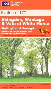
Abingdon, Wantage and Vale of White Horse: Sheet 170 (Explorer Maps)
by Ordnance Survey
- Used
- very good
- Paperback
- Condition
- Used - Very Good
- Binding
- Paperback
- ISBN 10 / ISBN 13
- 9780319217948 / 0319217949
- Quantity Available
- 1
- Seller
-
Reading, United Kingdom
- Item Price
-
£7.00£3.50Save £3.50!£10.00 shipping to USA
Show Details
Item Price
£7.00£3.50
Save £3.50
!
£10.00
shipping to USA

Atlas Antiquus
by Keipert, Heinrich
- Used
- good
- Hardcover
- Condition
- Used - Good
- Binding
- Hardcover
- Quantity Available
- 1
- Seller
-
Reading, United Kingdom
- Item Price
-
£100.00£90.00Save £10.00!£10.00 shipping to USA
Show Details
Description:
Berlin: Dietrich Reimer, 1863. Book. Good. Hardback. Folio - over 12" - 15" tall. Zehn Karten zur Alten Geschichte Entworfen und Bearbeitet. Title page lists 10 maps, in fact there are 14, the index does not include Aegyptus and Phoenice et Palaestina, Roma Urbs and Forum Romanum, Italia, Jerusalem and Palestina oder Kanaan all single page maps with the exception of Italia which is a double page. Spine is damaged, not affecting contents..
Item Price
£100.00£90.00
Save £10.00
!
£10.00
shipping to USA
Atlas Geography Europe
by Gill, George
- Used
- good
- Paperback
- Condition
- Used - Good
- Binding
- Paperback
- Quantity Available
- 1
- Seller
-
Reading, United Kingdom
- Item Price
-
£5.00£2.50Save £2.50!£10.00 shipping to USA
Show Details
Description:
London: George Gill & Sons Book. Good. Paperback. 12mo - over 6¾" - 7¾" tall. 5 x 7.25"; 44 pages; paper covers; early school/text book with some coloured maps; some pencil marks to margins. Not dated, but appears c1920..
Item Price
£5.00£2.50
Save £2.50
!
£10.00
shipping to USA
Bielefeld - Stadt Sparkasse
by No Author
- Used
- good
- Paperback
- Condition
- Used - Good
- Binding
- Paperback
- Quantity Available
- 1
- Seller
-
Reading, United Kingdom
- Item Price
-
£5.00£2.50Save £2.50!£10.00 shipping to USA
Show Details
Description:
Bielefeld: Starfold Book. Good. Paperback. 64mo - up to 3" tall. Wonderful colour map presented in a concertina fold-out format. 40cms x 17cms extended. Nice clean copy with no tears..
Item Price
£5.00£2.50
Save £2.50
!
£10.00
shipping to USA
Catalogue of Maps and Plans in the Exhibition of Local Maps and Map Making
by Baines, J. Mainwaring
- Used
- good
- Paperback
- Condition
- Used - Good
- Binding
- Paperback
- Quantity Available
- 1
- Seller
-
Reading, United Kingdom
- Item Price
-
£10.00£8.00Save £2.00!£10.00 shipping to USA
Show Details
Description:
Hastings: Museum Publications, 1936. Book. Good. Paperback. 8vo - over 7¾" - 9¾" tall. 16 pages. Catalogue of the exhibition held January 11th to February 29th, 1936. Number Ten in the New Series..
Item Price
£10.00£8.00
Save £2.00
!
£10.00
shipping to USA
Fox's Map and Street Reference Plan - Hayes and District
by No Author
- Used
- good
- Paperback
- Condition
- Used - Good
- Binding
- Paperback
- Quantity Available
- 1
- Seller
-
Reading, United Kingdom
- Item Price
-
£4.00£2.00Save £2.00!£10.00 shipping to USA
Show Details
Description:
Harrow: H. A. Fox, 1950. Book. Good. Paperback. 12mo - over 6¾" - 7¾" tall. 4.5 x 7.25; fold-out map printed on paper; good; Approx. 4" to a mile;.
Item Price
£4.00£2.00
Save £2.00
!
£10.00
shipping to USA
Gill's Atlas Geography
by Gill, George
- Used
- good
- Paperback
- Condition
- Used - Good
- Binding
- Paperback
- Quantity Available
- 1
- Seller
-
Reading, United Kingdom
- Item Price
-
£4.00£2.00Save £2.00!£10.00 shipping to USA
Show Details
Description:
London: George Gill & Sons Book. Good. Paperback. 12mo - over 6¾" - 7¾" tall. 5 x 7"; 32 pages; paper covers; early school/text book with black and white maps; some pencil marks to margins; bumped to edges. Not dated, but appears c1920..
Item Price
£4.00£2.00
Save £2.00
!
£10.00
shipping to USA
Guildford and Farnham: Sheet 145 (Explorer Maps)
by Ordnance Survey
- Used
- very good
- Paperback
- Condition
- Used - Very Good
- Binding
- Paperback
- ISBN 10 / ISBN 13
- 9780319235133 / 0319235130
- Quantity Available
- 1
- Seller
-
Reading, United Kingdom
- Item Price
-
£7.00£3.50Save £3.50!£10.00 shipping to USA
Show Details
Description:
Ordnance Survey, 2003. Book. Very Good. Paperback. Almost as new..
Item Price
£7.00£3.50
Save £3.50
!
£10.00
shipping to USA
Kandersteg und Undumbegung
by No Author
- Used
- good
- Paperback
- Condition
- Used - Good
- Binding
- Paperback
- Quantity Available
- 1
- Seller
-
Reading, United Kingdom
- Item Price
-
£12.00£9.60Save £2.40!£10.00 shipping to USA
Show Details
Description:
Berne: Kümmerly & Frey Book. Good. Paperback. 12mo - over 6¾" - 7¾" tall. Fold out colour map - 60cms x 56cms (24x 22 inches) Wonderful colour map. Vergrösserung der 1:50000 mit Bewilliung der Landestopographie vom 7.2.64. Covers are damaged without loss, but map is complete and bright..
Item Price
£12.00£9.60
Save £2.40
!
£10.00
shipping to USA
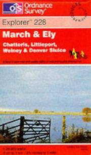
Stock Photo: Cover May Be Different
March and Ely: Sheet 228 (Explorer Maps)
by Ordnance Survey
- Used
- very good
- Paperback
- Condition
- Used - Very Good
- Binding
- Paperback
- ISBN 10 / ISBN 13
- 9780319218600 / 0319218600
- Quantity Available
- 1
- Seller
-
Reading, United Kingdom
- Item Price
-
£7.00£3.50Save £3.50!£10.00 shipping to USA
Show Details
Description:
Ordnance Survey, 2000. Book. Very Good. Paperback. Almost as new..
Item Price
£7.00£3.50
Save £3.50
!
£10.00
shipping to USA
New Chart of the British Isles
by No Author
- Used
- good
- Hardcover
- Condition
- Used - Good
- Binding
- Hardcover
- Quantity Available
- 1
- Seller
-
Reading, United Kingdom
- Item Price
-
£25.00£21.25Save £3.75!£10.00 shipping to USA
Show Details
Description:
Manchester: Richardson (Publishers) Limited Book. Good. Hardback. 4to - over 9¾" - 12" tall. Large, muslin-backed, brightly-coloured folding map. Full size 48"x38". Showing Railways, Steamship Routes (with Distances), Ports, Rivers, Canals, Main Roads, Distances between Towns, and Rainfall. With Additional Inset Maps, Diagrams, and Tabulated Motor & Other Information. Natural Scale 1:950,000 or 1 Inch = 15 Miles. Border crammed with information, index gazetteer to towns, motor speed limits and registration marks, approximate fares and time occupied in travelling from London to various parts of the world, times taken by letters from London in times of peace, weights & measures, approximate duration of railway journeys, diagrams showing proportions and numbers of males in the various occupations, the same for females, coinage, legal notes, etc. Green cloth with black titles, a little rubbed at edges and corners. Priced at 42 shillings. Tipped to front pastedown is…
Read More Item Price
£25.00£21.25
Save £3.75
!
£10.00
shipping to USA
Ordnance Survey Contour Road Map of Land's End and Lizard
by No Author
- Used
- good
- Paperback
- Condition
- Used - Good
- Binding
- Paperback
- Quantity Available
- 1
- Seller
-
Reading, United Kingdom
- Item Price
-
£15.00£12.00Save £3.00!£10.00 shipping to USA
Show Details
Description:
Southampton: Colonel Sir Charles Close, 1919. Book. Good. Paperback. folded cloth; Popular Edition Price 2/6 - Scale One Inch to One Mile; good copy, slightly dusty, with some wear to folds;.
Item Price
£15.00£12.00
Save £3.00
!
£10.00
shipping to USA
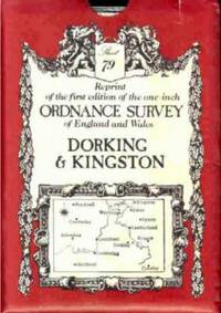
Stock Photo: Cover May Be Different
Ordnance Survey Maps: Dorking No. 79 (Victorian Ordnance Survey)
by No Author
- Used
- good
- Paperback
- Condition
- Used - Good
- Edition
- Reprint
- Binding
- Paperback
- ISBN 10 / ISBN 13
- 9780715344385 / 0715344382
- Quantity Available
- 1
- Seller
-
Reading, United Kingdom
- Item Price
-
£5.00£2.50Save £2.50!£10.00 shipping to USA
Show Details
Description:
David & Charles, 1979. Book. Good. Paperback. Reprint. 4vo - over 7¾" - 9¾" Tall. Folded map. Slipcase rubbed to corners..
Item Price
£5.00£2.50
Save £2.50
!
£10.00
shipping to USA
Paterson'sroads: being an entirely original and accurate descripton of all the Direct and Principal Cross Roads in England and Wales with Part of Scotland
by Patterson
- Used
- poor
- Hardcover
- Condition
- Used - Poor
- Edition
- Eighteenth
- Binding
- Hardcover
- Quantity Available
- 1
- Seller
-
Reading, United Kingdom
- Item Price
-
£30.00£25.50Save £4.50!£10.00 shipping to USA
Show Details
Description:
Paternoster Row: Longmans, 1826. Book. Illus. by An entirely new set of Maps by Edward Mogg. Poor. Full-Leather. Eighteenth. 715 pages. Leatherbound. Book covers detached but present. Maps attached are...... General Map. London to Holyhead. Isle of Wight - 6th plate. Isle of Thanet and adjacent country. Route from Deal to Hythe - Plate 11. Route from Rye to Eastbourne - Plate 1V. Route from New Shoreham to Chichester - PLate V1. The Country around Southampton - PLate V111. Lakes of Cumberland and Lancashire - Plate 7th. MISSING PLATES Hythe to Rye - Plate 111 and Eastbourne to Shoreham - Plate V. From Chichester to Fareham - Plate V11. Maps are complete but very folded on light tissue papers..
Item Price
£30.00£25.50
Save £4.50
!
£10.00
shipping to USA
Philip's Select Atlas of Physical and Political Geography
by Philip, George
- Used
- Hardcover
- Condition
- Used - Good Reading Copy
- Binding
- Hardcover
- Quantity Available
- 1
- Seller
-
Reading, United Kingdom
- Item Price
-
£40.00£34.00Save £6.00!£10.00 shipping to USA
Show Details
Description:
London: George Philip & Son Book. Good Reading Copy. Hardback. 4to - over 9¾" - 12" tall. Although not dated, the map of Canada includes the District of Ungava which was a regional administrative district of Canada's Northwest Territories from 1895 to 1912. Free front endpaper and title page are detached but present. This is a new and enlarged edition containing 40 coloured plates, ideal for framing..
Item Price
£40.00£34.00
Save £6.00
!
£10.00
shipping to USA
Plan De Paris
by No Author
- Used
- good
- Hardcover
- Condition
- Used - Good
- Binding
- Hardcover
- Quantity Available
- 1
- Seller
-
Reading, United Kingdom
- Item Price
-
£6.00£3.00Save £3.00!£10.00 shipping to USA
Show Details
Description:
Paris: Librairie Hachette Book. Good. Hardback. 12mo - over 6¾" - 7¾" tall. 45 pages together with fold-out coloured map. Map is chipped and torn, but almost complete. Liste Alphabétique starts with Abattoirs and finishes with Vélodromes..
Item Price
£6.00£3.00
Save £3.00
!
£10.00
shipping to USA
Rac Guide & Handbook 1967, The
by No Author
- Used
- Hardcover
- Condition
- Used - Good Reading
- Binding
- Hardcover
- Quantity Available
- 1
- Seller
-
Reading, United Kingdom
- Item Price
-
£8.00£4.00Save £4.00!£10.00 shipping to USA
Show Details
Description:
1966. Book. Good Reading. Hardback. 4vo - over 7¾" - 9¾" Tall. 709 pages plus adverts and maps..
Item Price
£8.00£4.00
Save £4.00
!
£10.00
shipping to USA

Stock Photo: Cover May Be Different
Reading, Wokingham and Pangbourne (Explorer Maps)
by Ordnance Survey
- Used
- very good
- Paperback
- Condition
- Used - Very Good
- Binding
- Paperback
- ISBN 10 / ISBN 13
- 9780319217849 / 0319217841
- Quantity Available
- 1
- Seller
-
Reading, United Kingdom
- Item Price
-
£7.00£3.50Save £3.50!£10.00 shipping to USA
Show Details
Description:
Ordnance Survey, 1998. Book. Very Good. Paperback. Almost as new..
Item Price
£7.00£3.50
Save £3.50
!
£10.00
shipping to USA

Stock Photo: Cover May Be Different
Shape of the World, The
by Berthon S. and Robinson A.
- Used
- very good
- Hardcover
- Condition
- Used - Very Good
- Binding
- Hardcover
- ISBN 10 / ISBN 13
- 9780540012299 / 0540012297
- Quantity Available
- 1
- Seller
-
Reading, United Kingdom
- Item Price
-
£15.00£12.00Save £3.00!£10.00 shipping to USA
Show Details
Description:
London: George Philip, 1991. Book. Very Good. Hardback. 4to - over 9¾" - 12" tall. 192pp; black cloth with silver; dustwrapper; a very clean copy; It is a history of mapmaking and scientific invention drawn from many ages and countries, from the first crude maps to the pictures of Apollo 8 in 1968;.
Item Price
£15.00£12.00
Save £3.00
!
£10.00
shipping to USA
Stanford's General Map of the World on Mercator's Projection
by No Author
- Used
- good
- Paperback
- Condition
- Used - Good
- Binding
- Paperback
- Quantity Available
- 1
- Seller
-
Reading, United Kingdom
- Item Price
-
£5.00£2.50Save £2.50!£10.00 shipping to USA
Show Details
Description:
George Philip & Son, 1964. Book. Good. Paperback. 29 x 41 approx size Map showing Towns, Principal Canals, Heights in feet, Trust Territories und the United Nations (bear in mind the date 1964) International Bounderies, Internal Administrative Bounderies, Princial Shipping Routes in Nautical Miles..
Item Price
£5.00£2.50
Save £2.50
!
£10.00
shipping to USA

Didn’t find what you’re looking for?
Try adding this search to your want list. Millions of books are added to our site everyday and when we find one that matches your search, we’ll send you an email. Best of all, it’s free.
Add to Want List

Are you a frequent reader or book collector?
Join the Bibliophile's Club and save 10% on every purchase, every day — up to $20 savings per order!

Social Responsibility
Did you know that since 2004, Biblio has used its profits to build 16 public libraries in rural villages of South America?
