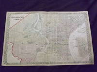
Description:
Unbound, colored engraved map, lined boarder, 23"x 15". Some toning, darkening and aging, a couple of small margin tears, three with archival tape repairs, slight corner crease; overall a nice impression, about very good. Maps are wrapped with acid free board, or in rigid sleeves. The Mitchell family started to produce atlases in 1846, and continued into the early 1890s. Around 1860, S. Augustus Mitchell Jr. took over, and the atlas would be called Mitchell's New General Atlas. This is a fairly colorful double page map of the city of Philadelphia from the 1872 installment. W.H. Gamble is credited for this map. Unlike previous Mitchell maps, this one does not have the traditional decorative boarder. The Camden portion of the map is to the side, and almost set up as an inset. Ristow 311-313. Phillips 907.
Philadelphia by MITCHELL, Samuel Augustus Sr - 1853
by MITCHELL, Samuel Augustus Sr
Similar copies are shown below.
Similar copies are shown to the right.

Philadelphia
by MITCHELL, Samuel Augustus Sr
- Used
Philadelphia: Mitchell, Samuel Augustus, 1853. unbound. Map. Engraving and lithograph with original hand coloring. Image measures 15.75" x 12.75".<br/> <br/> Beautiful town plan of Philadelphia. Shows streets, notable buildings and institutions (listed in numbered key), parks, railroad and wards. Small tear bottom center margin, chips along right and left margins and top right corner, none affecting image. <br> <br> Samuel Augustus Mitchell Sr. (1792-1868) was one of the leaders in American cartography of the 19th century and pioneered the conversion of engraved map plates to more affordable lithographic plates. His son, Samuel Augustus Mitchell Jr. continued his father's successful mapmaking and publishing business, and was one of the most prolific and renowned 19th century American publishers.<br/> <br/>
-
Bookseller
Argosy Book Store
 (US)
(US)
- Format/Binding Unbound
- Book Condition Used
- Quantity Available 1
- Publisher Mitchell, Samuel Augustus
- Place of Publication Philadelphia
- Date Published 1853
We have 6 copies available starting at £53.07.
Philadelphia and Camden.
by Mitchell, Samuel Augustus Jr
- Used
- Condition
- Used
- Quantity Available
- 1
- Seller
-
Florham Park, New Jersey, United States
- Item Price
-
£53.07
Show Details
Item Price
£53.07

Plan of Philadelphia
by Mitchell, Samuel Augustus Jr
- Used
- Condition
- Used
- Quantity Available
- 1
- Seller
-
Florham Park, New Jersey, United States
- Item Price
-
£61.23
Show Details
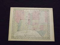
Description:
Unbound, colored engraved map, decorative boarder, 14"x 11". Slight toning and aging; overall bright and clear and in very good shape. Maps are wrapped with acid free board, or in rigid sleeves. The Mitchell family started to produce atlases in 1846, and continued into the early 1890s. Around 1860, S. Augustus Mitchell Jr. took over, and the atlas would be called Mitchell's New General Atlas. This is a colorful map of the city of Philadelphia from the 1870 installment of that atlas. Ristow 311-313
Item Price
£61.23
Plan of Philadelphia.
by Mitchell, Samuel Augustus Jr
- Used
- Condition
- Used
- Quantity Available
- 1
- Seller
-
Florham Park, New Jersey, United States
- Item Price
-
£61.23
Show Details
Description:
Unbound, colored engraved map, decorative boarder, 14" x 11". Slight browning and aging; overall bright and clean and in very good shape. Maps are wrapped with acid free board, or in rigid sleeves. The Mitchell family started to produce atlases in 1846, and continued into the early 1890s. Around 1860, S. Augustus Mitchell Jr. took over, and the atlas would be called Mitchell's New General Atlas. This is a colorful map of the city of Philadelphia from the 1869 installment of that atlas. Unlike later Mitchell atlases, which often include Camden, New Jersey, this map features only Philadelphia. Extra postage may be required. Ristow 311-313.
Item Price
£61.23
Plan of the City of Philadelphia and Camden
by Mitchell, Samuel Augustus Jr
- Used
- Condition
- Used
- Quantity Available
- 1
- Seller
-
Florham Park, New Jersey, United States
- Item Price
-
£69.39
Show Details
Description:
Philadelphia: Bradley, 1882. Unbound, colored engraved map, decorative boarder, 22 1/2"x 14 1/2". Slight toning and aging; overall bright and clear and in very good shape. Maps are wrapped with acid free board, or in rigid sleeves. The Mitchell family started to produce atlases in 1846, and continued into the early 1890s. Around 1860, S. Augustus Mitchell Jr. took over, and the atlas would be called Mitchell's New General Atlas. This is a fairly colorful double page map of the city of Philadelphia from the 1882 installment. The Camden portion of the map is to the side, and almost set up as an inset. Ristow 311-313 Phillips 907
Item Price
£69.39
Plan of Philadelphia
by Mitchell, Samuel Augustus Jr
- Used
- Condition
- Used
- Quantity Available
- 1
- Seller
-
Florham Park, New Jersey, United States
- Item Price
-
£69.39
Show Details
Description:
Philadelphia, 1864. Unbound, colored engraved map, decorative boarder, 14"x 11". Slight toning and aging; overall bright and clear and in very good shape. Maps are wrapped with acid free board, or in rigid sleeves. The Mitchell family started to produce atlases in 1846, and continued into the early 1890s. Around 1860, S. Augustus Mitchell Jr. took over, and the atlas would be called Mitchell's New General Atlas. This is a colorful map of the city of Philadelphia from the 1864 installment of that atlas. Ristow 311-313
Item Price
£69.39
Plan of Philadelphia
by Mitchell, Samuel Augustus Jr
- Used
- Condition
- Used
- Quantity Available
- 1
- Seller
-
Florham Park, New Jersey, United States
- Item Price
-
£69.39
Show Details
Description:
Philadelphia, 1861. Unbound, colored engraved map, decorative boarder, 14"x 11". Slight toning and aging, a few small chips at the top edge; overall bright and clear and in very good shape. Maps are wrapped with acid free board, or in rigid sleeves. The Mitchell family started to produce atlases in 1846, and continued into the early 1890s. Around 1860, S. Augustus Mitchell Jr. took over, and the atlas would be called Mitchell's New General Atlas. This is a colorful map of the city of Philadelphia from the 1861 installment of that atlas. Ristow 311-313
Item Price
£69.39