Click for full-size.


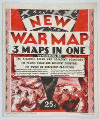
New War Map - 3 Maps in One. Consisting of: The Atlantic Ocean and Adjacent Countries, The Pacific Ocean and Adjacent Countries, The World on Mercators Projection
by [W.W. I. I.] Gross, Alexander
- Used
- first
- Condition
- Very good condition
- Seller
-
Garrison, New York, United States
Payment Methods Accepted
About This Item
New York: Geographia, 1941. First printing. Maps. Very good condition. A war map published early on in the conflict - the Japanese occupied area includes Northern China, Taiwan & Indo China, but Singapore is still free. All occupied terretories in each arena are denoted in red. Oil bunkering stations, coaling stations and the US bases leased from Britain are also marked in red. An unusual notation delineates all the "deep" parts of the respective oceans. The cover announces " ..contains a vast amount of information that renders it helpful in following the daily war news." The Pacific & Atlantic Ocean maps are color, the World map b&w. Measures unfolded measures 27 x 41 inches, folded 10 3/8 x 13 3/8. OCLC 13040283.
Reviews
(Log in or Create an Account first!)
Details
- Seller
- Antipodean Books, Maps & Prints
 (US)
(US)
- Seller's Inventory #
- 26343
- Title
- New War Map - 3 Maps in One. Consisting of: The Atlantic Ocean and Adjacent Countries, The Pacific Ocean and Adjacent Countries, The World on Mercators Projection
- Author
- [W.W. I. I.] Gross, Alexander
- Format/Binding
- Maps
- Book Condition
- Used - Very good condition
- Quantity Available
- 1
- Edition
- First printing
- Publisher
- Geographia
- Place of Publication
- New York
- Date Published
- 1941
- Bookseller catalogs
- MAPS; CHINA; WWII; JAPAN;
Terms of Sale
Antipodean Books, Maps & Prints
30 day return guarantee, with full refund including shipping costs for up to 10 days after delivery if an item arrives mis-described or damaged.
About the Seller
Antipodean Books, Maps & Prints
Biblio member since 2009
Garrison, New York
About Antipodean Books, Maps & Prints
Booksellers for over 40 years, members of prominent trade associations (ABAA, ILAB, ANZAAB, IMCOS, ANZMS, PBFA). We are located at Garrison NY, a stone's throw from the Metro North Hudson line train, just over 1 hr. from NYC on the banks of the Hudson River. Books, maps, prints & ephemera bought & sold.
Frequently asked questions
This Book’s Categories

Collecting Aleister Crowley
Aleister Crowley was a well-known and highly controversial figure in the first half of the 20th Century. A writer, occultist, magician, and mountaineer, Crowley impacted a diverse collection of sub-cultures and interests. See collectible Crowley from Biblio booksellers.

Michael Bond - the man behind Paddington Bear
“All the same ... it’s a very important name. And I don’t expect there are many bears in the world called Paddington!”
A lonely toy bear on an empty shop shelf on Christmas Eve in 1956 first captured the attention of Michael Bond, who kindly shared Paddington with the world.