Description:
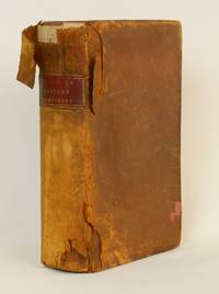
Charlestown: Samuel Etheridge, 1802. First edition. Octavo. [712] pages and all 18 folding maps. Contemporary tree calf with maroon morocco gilt label. Early owner's signature (Samuel A. Bradley). some rubbing to joint and extremities but overall a very good copy.
Of the five copies recorded at auction by RBH, none had the complete contingent of 18 maps. Rare with all 18 maps and in the original binding. The Father of American Geography extends his skills across the ocean. Some maps drawn by A. Adams and Cyrus Harris, and engraved by Enoch Gridley. Designed as a second volume to The American Gazeteer.
A New Gazetteer of the Eastern Continent; or, a Geographical Dictionary: Containing, In Alphabetical Order, a Description of all the Countries, Kingdoms, States, Cities, Towns, Principal Rivers, Lakes, Harbours, Mountains, &c. &c. in Europe, Asia, Africa, and Their Adjacent Islands by Morse, Jedidiah and Parish, Elijah - 1802
by Morse, Jedidiah and Parish, Elijah
Similar copies are shown below.
Similar copies are shown to the right.
A New Gazetteer of the Eastern Continent; or, a Geographical Dictionary: Containing, In Alphabetical Order, a Description of all the Countries, Kingdoms, States, Cities, Towns, Principal Rivers, Lakes, Harbours, Mountains, &c. &c. in Europe, Asia, Africa, and Their Adjacent Islands
by Morse, Jedidiah and Parish, Elijah
- Used
- fair
- first
Charlestown: Samuel Etheridge, 1802. First Edition. Leather. Fair. Octavo size, approx. [600] pp. Jedidiah Morse (1761-1826) published numerous volumes on geography during his life; the publication of his first thorough geographical work, "The American Gazetteer", garnered him the title "the father of American geography". "A New Gazetteer" serves as a second volume, this one dealing with the geography of Europe, Asia, and Africa, with accompanying maps detailing the varied topography and cities found in these widely different continents.
This volume is the first edition of Morse's book, written with Elijah Parish (1762-1825), a clergyman in New England who was a member of the American Antiquarian Society.
___DESCRIPTION: Full brown leather with replacement leather binding by a prior owner over the original leather with a cut-out for the spine label, red leather spine label with gilt ruled borders and gilt lettering, frontispiece a fold-out map of Europe, text in double columns, seventeen black-and-white fold-out maps (including frontispiece) throughout; octavo size (8.75" by 5.75"), approximately 600 pages, unnumbered.
___CONDITION: Volume is fair only mostly due to the binding; it has a sturdy and square text block and is collated complete; condition issues include soiling and chipping to the leather cover with a piece at the head of the spine beginning to detach, overall edge wear, corners bumped, front hinge is loose, preliminary pages show substantial edgewear but no loss to text, soiling and foxing throughout the interior pages, the gutter at the section "HOT" is cracked, and two of the maps, the frontispiece and one at the section "SYD", have one panel detached but present. All maps are collated and present; please note that the title page has "Illustrated with eighteen maps" printed, however, there are seventeen maps listed on the note to the binder at the rear of the book, and all of these are present in the book.
___POSTAGE: International customers, please note that additional postage may apply as the standard does not always cover costs; please inquire for details.
___Swan's Fine Books is pleased to be a member of the ABAA, ILAB, and IOBA and we stand behind every book we sell. Please contact us with any questions you may have, we are here to help.
-
Bookseller
Swan's Fine Books
 (US)
(US)
- Format/Binding Leather
- Book Condition Used - Fair
- Quantity Available 1
- Edition First Edition
- Publisher Samuel Etheridge
- Place of Publication Charlestown
- Date Published 1802
- Keywords Exploration, Geography, Maps, Gazetteer, Cartography, Travel, World Geography
We have 1 copies available starting at £609.68.

A New Gazetteer of the Eastern Continent; or, a Geographical Dictionary: Containing, in Alphabetical Order, a Description of All the Countries, Kingdoms, States, Cities, Towns, Principal Rivers, Lakes, Harbours, Mountains, &c. &c. in Europe, Asia, Africa, and Their Adjacent Islands.
by MORSE, Jedidiah & Elijah PARISH
- Used
- first
- Condition
- Used
- Quantity Available
- 1
- Seller
-
Portland, Oregon, United States
- Item Price
-
£609.68
Show Details
Item Price
£609.68