Description:
Shūseidō 衆星堂. [Reprint].. Tenpō 14 (1843).. Large folding handcoloured map of the thirteen provinces from which Mt. Fuji can be viewed. 159 x 178cm. Folds into paper covered card covers measuring 40 x 24cm. Title label upper cover. A little browning along folds, occasional spotting and soiling. A little worming causing approximately 1cm of loss in places. Two chops in lower section. A very striking and attractive map. This very large handsome map is a detailed map of the thirteen provinces from which one can see Mt. Fuji. Provinces shown are the eight provinces of the Kantō region, Sagami 相模, Musashi 武蔵, Kazusa 上総, Shimofusa 下総, Awa 安房, Kōzuke 上野, Shimotsuke 下野, and Hitachi, 常陸, and five other provinces, Izu 伊豆, Suruga 駿河, Tōtōmi 遠江, Kai 甲斐, and Shinano 信濃. The map…
Read More 南瞻部洲萬國掌菓之圖. [Nansen bushu bankoku shoka no zu]. [Map of All the Countries in Jambud-vipa]. by [FIRST JAPANESE BUDDHIST MAP OF THE WORLD] - 宝永7年 [1710]
by [FIRST JAPANESE BUDDHIST MAP OF THE WORLD]
![å��ç�»é�¨æ´²è�¬å��æ��è��ä¹�å��. [Nansen bushu bankoku shoka no zu]. [Map of All the Countries in Jambud-vipa]. by [FIRST JAPANESE BUDDHIST MAP OF THE WORLD] - 宝永7年 [1710]](https://d3525k1ryd2155.cloudfront.net/h/848/807/1081807848.0.m.jpg)
南瞻部洲萬國掌菓之圖. [Nansen bushu bankoku shoka no zu]. [Map of All the Countries in Jambud-vipa].
by [FIRST JAPANESE BUDDHIST MAP OF THE WORLD]
- Used
Kyoto.: 文臺軒宇平 [Bundaiken Uhei].. 宝永7年 [1710].. Hand coloured, black and white woodblock print map, 114 x 143cm. Folds into worn paper covered card covers 23.2 x 18.5cm presented in Japanese case. Some repaired insect damage in places, small chip upper right in blank section, some wear particularly on title. 南瞻部洲萬國掌菓之圖 'Nansen bushū bankoku shōka no zu' was the first Buddhist world map printed in Japan. Its popularity and influence was so great that for a period of nearly 200 years after its publication it formed the basis of all other Japanese Buddhist world maps.
To modern Western eyes this map appears at first glance as quite confusing. The world as we know it is not shown, the perspective is neither scientific nor even particularly inclusive of the West. It is an Asia-centric view of the world. Europe is included, but only as a group of islands at the top left of the map, Australia and Africa are not depicted and South America appears as a small island to the south of overly large Japan. At the top right of the map a land bridge connects the Asian continent with a not terribly large land of scattered mountain ranges which is now believed to be North America.
The purpose of creating this map was not for a scientific depiction of the latest knowledge. Although Japanese map makers would have been aware of European knowledge of the world at the time, having seen maps brought by Portuguese and Dutch traders to Japan, this map continues to follow in the tradition of Buddhist maps with only a glance in the direction of more contemporary knowledge. 'Nansen bushū bankoku shōka no zu' depicts the world as seen through Buddhist eyes, based on Buddhist sources, with the Himalayan region at its centre extending south to India, west to Europe and east to Japan and not to scale. At the lower corners and in a section to the left of the title along the upper margin is text written in Chinese characters with Japanese reading marks. Text along the upper edge lists 102 Buddhist works that the Buddhist Priest Hotan, sometimes known as Soshun, (1659? - 1738) the creator of this map, used in the compilation. Further the two blocks of text at the lower corners go into quite some detail about Hotan's purpose in making this map and the background to its creation. This Buddhist cosmological world map was enormously popular, very possibly in part because of the growing exposure to and rejection of European maps and ideas by the conservative Buddhist minds amongst the Japanese map buying public at the time. Before long the map was copied and these variant copies which included such changes as, presenting the text in kana, rather than Chinese characters, a script more widely read among the broad Japanese public at the time, began to appear on the market.
A copy of this handsome and significant map is one of the treasures from the collection of the National Library of Australia featured in 'Asian Treasures: Gems of the Written Word' by Andrew Gosling. Sources: NLA; The Buddhist World Map in Japan and its Contact with European Maps - Nobuo Muroga and Kazutaka Unno. 1962. .
-
Bookseller
Asia Bookroom
 (AU)
(AU)
- Book Condition Used
- Publisher 文臺軒宇平 [Bundaiken Uhei].
- Place of Publication Kyoto.
- Date Published 宝永7年 [1710]
- Keywords America, Buddhism, India, Japan, Japanese Language, Map, World Map, Zz_gallery_ephemera_and_maps, zz_ListOn_eBay

More Photos
富士見十三州輿地全圖. [Fujimi Jūsanshū yochi zenzu]. [Map of the Thirteen Provinces From Where Mt. Fuji Is Visible].
by AKIYAMA EINEN [OR NAGATOSHI] 秋山永年.
- Used
- Condition
- Used
- Edition
- [Reprint].
- Binding
- Unknown
- Quantity Available
- 1
- Seller
-
Canberra, Australian Capital Territory, Australia
- Item Price
-
£1,317.50
Show Details
Item Price
£1,317.50
A Chinese Street. To be cut, coloured and set up.
by [CHILDREN'S GAME].
- Used
- Hardcover
- Condition
- Used
- Binding
- Hardcover
- Quantity Available
- 1
- Seller
-
Canberra, Australian Capital Territory, Australia
- Item Price
-
£1,554.65
Show Details
Description:
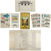
London.: Church of England Zenana Missionary Society.. No date. (circa1900).. Nine printed sheets each printed with people or items and showing the cut lines. Original chromolithograph card box repaired with acid free archival tape along folds. Some occasional light foxing on sheets, card covers browned and worn in places, a few other minor signs of wear but generally very good. 43 x 24cm. The first two sheets show Chinese people in clothes appropriate to their age, occupation etc. Those illustrated include The Opium Smoker, School-master, The General Shopkeeper, Native Biblewoman etc. Other sheets show furniture and fittings, a coloured illustration of the street, a black and white image of the city gate and a much larger sheet (50 x 87.5cm) which is an illustration of the street and onto which the other cut-outs when coloured and cut out are placed. .
Item Price
£1,554.65

More Photos
The Chater Collection. Pictures relating to China, Hong Kong, Macao, 1655-1860; with Historical and Descriptive Letterpress.
by ORANGE, JAMES.
- Used
- Hardcover
- Condition
- Used
- Edition
- Number 77 of a limited edition of 750 copies.
- Binding
- Hardcover
- Quantity Available
- 1
- Seller
-
Canberra, Australian Capital Territory, Australia
- Item Price
-
£2,108.00
Show Details
Description:
London.: Butterworth.. Number 77 of a limited edition of 750 copies.. 1924.. Maps including colour folding plan of City of Victoria, 18 colour plates, many in black and white, 528pp, bibliography, index, bright top edge gilt. Fore edge lightly browned, front endpapers browned, cloth very clean and bright, lettered in bright gilt, an exceptional copy in original slightly chipped dustjacket. 30.7 x 25.5cm. This remarkable book records the extraordinary collection that Hong Kong businessman Sir Paul Chater built. This volume includes descriptions and representations of the prints and maps within his collection. Paul Chater was an energetic and innovative man who though coming from disadvantage built an enviable business empire as well as involving himself with the government of Hong Kong. He served as Senior Unofficial Member of the Executive Council for 30 years ending only with his death. When Sir Paul Chater died in 1926 his collection of porcelain, prints and paintings together with Marble Hall,…
Read More Item Price
£2,108.00

More Photos
抗美援朝時事學習地圖. [Kang Mei yuan Chao shi shi xue xi di tu]. [Current Affairs Study Map - Resisting US Aggression and Aiding Korea].
by [YA XIN CARTOGRAPHIC STUDY SOCIETY].[亞新地學社].
- Used
- first
- Condition
- Used
- Edition
- 1st Edition.
- Binding
- Unknown
- Quantity Available
- 1
- Seller
-
Canberra, Australian Capital Territory, Australia
- Item Price
-
£1,449.25
Show Details
Description:
武昌.[Wuchang].: 亞新地學社.[Ya xin di xue she].. 1st Edition.. August1951.. Large detailed colour Chinese map of Korean War, folded, scale 1:15,000,000, three inset maps on corners, illustrated legend showing agricultural and mining resources lower margin, in original envelope. Some light wear along edges, small holes and wear at folds mended with archival tape, envelope torn with loss mended with archival tape. Inset map 兩個陣營力量對比 "Strength Comparison Between The Two Camps" upper left corner, scale 1: 170,000,000. The Peaceful Camp in red covering the majority of Asia and Europe, a list of 6 countries (Germany, Czech, Hungary, Romania, Bulgaria, Albania) are numbered and are also part of the Peaceful Camp. The Invader Camp in grey covering North America and small parts of Europe, a list of 3 nations (Netherlands, Belgium, Luxembourg) are numbered and are also part of the Invader Camp. Block of text in…
Read More Item Price
£1,449.25
![Map of Peking. 京城內外全圖 .[Jing cheng nei wai quan tu].](https://d3525k1ryd2155.cloudfront.net/h/215/732/1340732215.0.m.jpg)
Map of Peking. 京城內外全圖 .[Jing cheng nei wai quan tu].
by [BOXER REBELLION MAP OF BEIJING].
- Used
- Condition
- Used
- Binding
- Unknown
- Quantity Available
- 1
- Seller
-
Canberra, Australian Capital Territory, Australia
- Item Price
-
£4,084.25
Show Details
Description:
(Circa1900).. Large illustrated map of Beijing showing the city in the period following the invasion of the military forces of the Eight National Alliance, old folds, scale not given. Some scattered light foxing particularly at edges, short closed tear at fold lower edge, neat non acidic tape repair short section upper edge wear along folds, and a couple of small, unobtrusive holes with minor image loss. Blocks of text in traditional Chinese right and left upper sections stating each nation's occupied zone, Japanese text title accompanies the English title along the upper section of the map. 63.7 x 56.9cm. Very good overall. A rare and significant large Japanese woodblock map of Peking (Beijing), issued just after the suppression of the Boxer Rebellion. Centred on the Forbidden City, the map depicts Peking following the multinational suppression of the Boxer Rebellion or Yihetuan Movement of 1900. The map was issued to illustrate the areas of occupation associated with each of the powers in the Eight…
Read More Item Price
£4,084.25
More Photos
富士見十三州輿地全圖. [Fujimi Jūsanshū yochi zenzu]. [Map of the Thirteen Provinces From Where Mt. Fuji Is Visible].
by AKIYAMA EINEN [OR NAGATOSHI] 秋山永年.
- Used
- Condition
- Used
- Edition
- [Reprint].
- Binding
- Unknown
- Quantity Available
- 1
- Seller
-
Canberra, Australian Capital Territory, Australia
- Item Price
-
£1,317.50
Show Details
Description:
Shūseidō 衆星堂. [Reprint].. Tenpō 14 (1843).. Large folding handcoloured map of the thirteen provinces from which Mt. Fuji can be viewed. 159 x 178cm. Folds into paper covered card covers measuring 40 x 24cm. Title label upper cover. A little browning along folds, occasional spotting and soiling. A little worming causing approximately 1cm of loss in places. Two chops in lower section. A very striking and attractive map. This very large handsome map is a detailed map of the thirteen provinces from which one can see Mt. Fuji. Provinces shown are the eight provinces of the Kantō region, Sagami 相模, Musashi 武蔵, Kazusa 上総, Shimofusa 下総, Awa 安房, Kōzuke 上野, Shimotsuke 下野, and Hitachi, 常陸, and five other provinces, Izu 伊豆, Suruga 駿河, Tōtōmi 遠江, Kai 甲斐, and Shinano 信濃. The map…
Read More Item Price
£1,317.50
A Chinese Street. To be cut, coloured and set up.
by [CHILDREN'S GAME].
- Used
- Hardcover
- Condition
- Used
- Binding
- Hardcover
- Quantity Available
- 1
- Seller
-
Canberra, Australian Capital Territory, Australia
- Item Price
-
£1,554.65
Show Details
Description:
London.: Church of England Zenana Missionary Society.. No date. (circa1900).. Nine printed sheets each printed with people or items and showing the cut lines. Original chromolithograph card box repaired with acid free archival tape along folds. Some occasional light foxing on sheets, card covers browned and worn in places, a few other minor signs of wear but generally very good. 43 x 24cm. The first two sheets show Chinese people in clothes appropriate to their age, occupation etc. Those illustrated include The Opium Smoker, School-master, The General Shopkeeper, Native Biblewoman etc. Other sheets show furniture and fittings, a coloured illustration of the street, a black and white image of the city gate and a much larger sheet (50 x 87.5cm) which is an illustration of the street and onto which the other cut-outs when coloured and cut out are placed. .
Item Price
£1,554.65
More Photos
The Chater Collection. Pictures relating to China, Hong Kong, Macao, 1655-1860; with Historical and Descriptive Letterpress.
by ORANGE, JAMES.
- Used
- Hardcover
- Condition
- Used
- Edition
- Number 77 of a limited edition of 750 copies.
- Binding
- Hardcover
- Quantity Available
- 1
- Seller
-
Canberra, Australian Capital Territory, Australia
- Item Price
-
£2,108.00
Show Details
Description:
London.: Butterworth.. Number 77 of a limited edition of 750 copies.. 1924.. Maps including colour folding plan of City of Victoria, 18 colour plates, many in black and white, 528pp, bibliography, index, bright top edge gilt. Fore edge lightly browned, front endpapers browned, cloth very clean and bright, lettered in bright gilt, an exceptional copy in original slightly chipped dustjacket. 30.7 x 25.5cm. This remarkable book records the extraordinary collection that Hong Kong businessman Sir Paul Chater built. This volume includes descriptions and representations of the prints and maps within his collection. Paul Chater was an energetic and innovative man who though coming from disadvantage built an enviable business empire as well as involving himself with the government of Hong Kong. He served as Senior Unofficial Member of the Executive Council for 30 years ending only with his death. When Sir Paul Chater died in 1926 his collection of porcelain, prints and paintings together with Marble Hall,…
Read More Item Price
£2,108.00
More Photos
抗美援朝時事學習地圖. [Kang Mei yuan Chao shi shi xue xi di tu]. [Current Affairs Study Map - Resisting US Aggression and Aiding Korea].
by [YA XIN CARTOGRAPHIC STUDY SOCIETY].[亞新地學社].
- Used
- first
- Condition
- Used
- Edition
- 1st Edition.
- Binding
- Unknown
- Quantity Available
- 1
- Seller
-
Canberra, Australian Capital Territory, Australia
- Item Price
-
£1,449.25
Show Details
Description:
武昌.[Wuchang].: 亞新地學社.[Ya xin di xue she].. 1st Edition.. August1951.. Large detailed colour Chinese map of Korean War, folded, scale 1:15,000,000, three inset maps on corners, illustrated legend showing agricultural and mining resources lower margin, in original envelope. Some light wear along edges, small holes and wear at folds mended with archival tape, envelope torn with loss mended with archival tape. Inset map 兩個陣營力量對比 "Strength Comparison Between The Two Camps" upper left corner, scale 1: 170,000,000. The Peaceful Camp in red covering the majority of Asia and Europe, a list of 6 countries (Germany, Czech, Hungary, Romania, Bulgaria, Albania) are numbered and are also part of the Peaceful Camp. The Invader Camp in grey covering North America and small parts of Europe, a list of 3 nations (Netherlands, Belgium, Luxembourg) are numbered and are also part of the Invader Camp. Block of text in…
Read More Item Price
£1,449.25
Map of Peking. 京城內外全圖 .[Jing cheng nei wai quan tu].
by [BOXER REBELLION MAP OF BEIJING].
- Used
- Condition
- Used
- Binding
- Unknown
- Quantity Available
- 1
- Seller
-
Canberra, Australian Capital Territory, Australia
- Item Price
-
£4,084.25
Show Details
Description:
(Circa1900).. Large illustrated map of Beijing showing the city in the period following the invasion of the military forces of the Eight National Alliance, old folds, scale not given. Some scattered light foxing particularly at edges, short closed tear at fold lower edge, neat non acidic tape repair short section upper edge wear along folds, and a couple of small, unobtrusive holes with minor image loss. Blocks of text in traditional Chinese right and left upper sections stating each nation's occupied zone, Japanese text title accompanies the English title along the upper section of the map. 63.7 x 56.9cm. Very good overall. A rare and significant large Japanese woodblock map of Peking (Beijing), issued just after the suppression of the Boxer Rebellion. Centred on the Forbidden City, the map depicts Peking following the multinational suppression of the Boxer Rebellion or Yihetuan Movement of 1900. The map was issued to illustrate the areas of occupation associated with each of the powers in the Eight…
Read More Item Price
£4,084.25

More Photos
The Sky and the Forest
by Forester, C.S
- Used
- very good
- Hardcover
- first
- Condition
- Used - Very Good
- Jacket Condition
- Very Good
- Edition
- First Edition
- Binding
- Hardcover
- Quantity Available
- 1
- Seller
-
Salem, Oregon, United States
- Item Price
-
£28.48£17.09Save £13.96!
Show Details
Description:
C.S. Forester: The Sky and the Forest. Little, Brown and Company, Boston. Stated First Edition First Printing Thus August, 1948. Cover price $2.75. Used. VG BOOK/VG UNCLIPPED DUST JACKET. A story of a central Africa. By C.S. Forester, author of the Admiral Hornblower series.
Item Price
£28.48£17.09
Save £13.96
!
![Alaska and Klondike Region; [With inset of Klondike Region on the Upper Yukon detail] [From an...](https://d3525k1ryd2155.cloudfront.net/h/062/537/1339537062.0.m.jpg)
Alaska and Klondike Region; [With inset of Klondike Region on the Upper Yukon detail] [From an atlas, "Gazetteer of Alaska and Yukon Region " pp. 105 and 106]
by Miller, J. Martin
- Used
- very good
- Condition
- Used - Very Good
- Edition
- Unknown
- Quantity Available
- 1
- Seller
-
Sebastopol, California, United States
- Item Price
-
£31.84
Show Details
Description:
Chicago: J. Martin Miller, 1899. Unknown. Map. Very Good. [Map copyright 1899, printing date of Atlas later] [19.875x15.125in]; Colored map of Alaska with steamer routes from Portland and Seattle, insets of the Klondike Region on the Upper Yukon and Western portion of Aleutian Islands; On verso index of places and names with two large black and white images; Age toning to all edges, water stain marks on bottom, slight printing offset of colors, small chips and closed tears to lower edge;.
Item Price
£31.84

Zemepis Sveta - Monsunova Asie
by De La Blache, P. Vidal; Gallois, L
- Used
- Hardcover
- Condition
- Used - Very Good Condition
- Jacket Condition
- No Dust Jacket
- Binding
- Hardcover
- Quantity Available
- 1
- Seller
-
Oak Point, Texas, United States
- Item Price
-
£48.98
Show Details
Description:
Aventinum, Prague, Czechoslovakia, 1931. Hardcover. Very Good Condition/No Dust Jacket. Text entirely in Czech. Geography book on Asia with numerous photographs and maps. 1930 edition also available. Size: 4mo - over 9 3/4" - 12" tall. 400 pp. Pages are yellowed, but are tight and clean. Moderate shelfwear along the spine. Corners are lightly bumped. Quantity Available: 1. Shipped Weight: 3-5 pounds. Category: Travel & Places; Non-English Language::Czech; Pictures of this item not already displayed here available upon request. Inventory No: 001228. . Additional shipping charges may apply.
Item Price
£48.98

Zemepis Sveta - Monsunova Asie
by De La Blache, P. Vidal; Gallois, L
- Used
- Hardcover
- Condition
- Used - Very Good Condition
- Jacket Condition
- No Dust Jacket
- Binding
- Hardcover
- Quantity Available
- 1
- Seller
-
Oak Point, Texas, United States
- Item Price
-
£48.98
Show Details
Description:
Aventinum, Prague, Czechoslovakia, 1930. Hardcover. Very Good Condition/No Dust Jacket. Text entirely in Czech. Geography book on Asia with numerous photographs and maps. 1931 edition also available. Size: 4mo - over 9 3/4" - 12" tall. 400 pp. Pages are yellowed, but are tight and clean. Moderate shelfwear along the spine. Corners are lightly bumped. Quantity Available: 1. Shipped Weight: 3-5 pounds. Category: Travel & Places; Non-English Language::Czech; Pictures of this item not already displayed here available upon request. Inventory No: 001227. . Additional shipping charges may apply.
Item Price
£48.98

North America from the Best Authorities, Russell, ca.1800
by Russell
- Used
- Condition
- Used
- Quantity Available
- 1
- Seller
-
Plymouth, Devon, United Kingdom
- Item Price
-
£20.00
Show Details
Description:
Russell, J. : A General Map of North America from the Best Authorities. Nd but ca.1800. From "A New Geographical, Historical and Commercial Grammar and Present State of Several Kingdoms of the World." Copper engraving. Size approx 200 x 230mm. Two neat folds. Some age colouring to edges, otherwise very clean and bright.
Item Price
£20.00

Asia from the Best Authorities, Russell, ca.1800
by Russell
- Used
- Condition
- Used
- Quantity Available
- 1
- Seller
-
Plymouth, Devon, United Kingdom
- Item Price
-
£20.00
Show Details
Description:
Russell, J. : Asia from the Best Authorities. Nd but ca.1800. From "A New Geographical, Historical and Commercial Grammar and Present State of Several Kingdoms of the World". Copper engraving. Size approx 200 x 230mm. Two neat folds. Some age colouring to edges, otherwise clean and bright. Includes Arabia, India, Borneo, Japan, China and eastern Russia.
Item Price
£20.00
![MAP OF UTAH [Territory]](https://d3525k1ryd2155.cloudfront.net/h/836/461/1485461836.0.m.jpg)
More Photos
MAP OF UTAH [Territory]
- Used
- Condition
- Used - Very Good-
- Edition
- Original
- Quantity Available
- 1
- Seller
-
Williamsburg, Virginia, United States
- Item Price
-
£53.07
Show Details
Description:
New York, Richmond, Chicago, & Toledo: H. H. Hardesty, 1885. Original color lithographed map printed by Rand, McNally & Company, Engravers and published in HARDESTY'S HISTORICAL AND GEOGRAPHICAL ENCYCLOPEDIA: SPECIAL VIRGINIA EDITION. 19 3/8 inches by 13 1/4 inches on a 21" X 14 1/2" sheet. The map depicts the Territory of Utah in its final form--large areas had been removed and ceded to Nevada, Colorado, Wyoming, and Nebraska since Utah became a U. S. Territory in 1850. The issue of polygamy prevented statehood until it was finally granted in 1896. This map features railroads and topography and uses color to set off counties from each other. Unlike most atlas maps of the period, this map identifies most small towns. The map is guaranteed to be moe than 135 years old. The map is in about very good condition: generally clean and bright, with slight toning of paper and one faint water stain near the center-left edge of the map.. Original. Single Sheet. Very Good-. Elephant…
Read More Item Price
£53.07

Philips Special Map of the Nile, The Advance on Khartum and the Environs of Omdurman. Cc1900
by George Philips and Son,
- Used
- Condition
- Used
- Quantity Available
- 1
- Seller
-
Plymouth, Devon, United Kingdom
- Item Price
-
£26.00
Show Details
Description:
Philips Special map of the Nile illustrating the Advance on Khartum [Khartoum] with an enlargement of the environs of Omdurman [Omdur]. George Philips and Son, London and Liverpool Ca 1900. 580mm x 900mm folded map. Front title wrapper has come loose, not affecting map area. Three maps are displayed within the sheet. Map1. Map of the Nile Valley 520mm x 300mm showing the approaches of Khartum. Scale 1inch to 100 Geographical miles. Coloured indicating Possessions and Protectorates of European Powers. Map 2. Special map of the Nile from Dongola to Khartum. Scale 16 miles to the inch. Coloured. In set in this map is Map3. Environs of Omdurman, Scale 5 statute miles to the inch. Some small breaks at some folds, not affecting imagery or use of map. Title label is damaged, the map is clean and bright, probably unused. A very interesting record.
Item Price
£26.00

Last Tales
by Dinesen, Isak
- Used
- very good
- Hardcover
- first
- Condition
- Used - Very Good
- Jacket Condition
- Good+
- Edition
- First Edition
- Binding
- Hardcover
- Quantity Available
- 1
- Seller
-
Salem, Oregon, United States
- Item Price
-
£97.97£58.78Save £48.00!
Show Details
Description:
Dinesen, Isak: Last Tales, A Collection of Twelve New Tales of Compelling Beauty 1957, Random House. First Edition. Stated First Printing Thus. Used. Very Good/Good+ original red dust jacket, price-clipped. Jacket states 11/57 on front flap. 5 3/4 X
Item Price
£97.97£58.78
Save £48.00
!

The Adventure of Wrangel Island
by Vilhjalmur Stefansson
- Used
- good
- Hardcover
- first
- Condition
- Used - Good
- Jacket Condition
- No DJ Included
- Edition
- First Edition
- Binding
- Hardcover
- Quantity Available
- 1
- Seller
-
Salem, Oregon, United States
- Item Price
-
£101.96£61.17Save £49.96!
Show Details
Description:
The Adventure of Wrangel Island, Alaska (1925 Macmillan 1st Edition) HISTORY OF ALASKA. EXLIB. Good Condition/ No DJ included. Fold-out map affixed to binding at the back of the book has never been opened. The story of the (unsuccessful) attempted colonization of Wrangel Island Alaska. 413 pages plus appendix, Index. Titling is still bright. A clean, solid copy. Scarce.
Item Price
£101.96£61.17
Save £49.96
!
