Mitchell's School Atlas; Comprising the Maps and Tables Designed to Accompany Mitchell's School and Family Geography; the 1858 Edition by Mitchell, A. Augustus and J H Young - 1858
by Mitchell, A. Augustus and J H Young
Mitchell's School Atlas; Comprising the Maps and Tables Designed to Accompany Mitchell's School and Family Geography; the 1858 Edition
by Mitchell, A. Augustus and J H Young
- Used
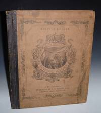
Philadelphia: E.H. Butler & Company, 1858. Quarto. 9 pages, 23 unnumbered leaves. The maps are all from 1852 plates. OCLC shows copies are found at the Newberry and the Library of Congress. It has all 32 maps (some of which are inset maps, e.g., Galveston on the Texas map (no. 13). Of particular interest, is 1. (no. 5), Map of the United States which shows New Mexico Territory which extends into what was later parts of Nevada and Colorado. The southern part of New Mexico was called Arizona but it was not until the Civil War that Arizona became a separate territory. This map was issued two years prior to the Gadsen Purchase. 2. (no. 13), the State of Texas Besides showing Texas as it was after 1850, it also both in the insert and the full size map shows the range of the Comanche as well as the Apaches. This copy belonged to a Silas Wright of Greenwood. Bound in pictorial paper covered boards, backed in black morocco, some staining to boards, small edge tears to spine, toning or occasional spots of foxing to margins. A very good copy.
-
Bookseller
Alcuin Books, ABAA-ILAB
 (US)
(US)
- Book Condition Used
- Publisher E.H. Butler & Company
- Place of Publication Philadelphia
- Date Published 1858
- Keywords Texas Map in The1850's; New Mexico Territory 1850's; Comanches and Apaches in the 1850's Southwest