Description:
Unbound, colored engraved map, 16 " x 13". Slight toning, darkening and aging; overall bright and clean and in very good condition. Maps are wrapped with acid free board, or in rigid sleeves. Beginning with J. H. Colton (1800-1893), the Colton family published atlases for over 30 years. Colton's Atlas of the World was first published in 1855 in a large two volume set. In 1857 it became Colton's General Atlas, and Colton's sons, George Woolworth and Charles B. would take over the business. This map of Northern Michigan is from the 1857 edition of Colton's General Atlas, even though the copyright date on the map indicates 1855. The mapis unusual in that Lake Superior is emphasized, and only the northern portion of the state is shown. Extra postage may be required. Ristow 313-326.
Michigan by COLTON, J.H. & Co - 1855
by COLTON, J.H. & Co
Similar copies are shown below.
Similar copies are shown to the right.

Michigan
by COLTON, J.H. & Co
- Used
- very good
New York: Colton, J.H., 1855. unbound. very good. Map. Engraving with original hand coloring. Image measures 16" x 12.75".<br/><br/> Nice clear map of Michigan divided into counties and townships. Shows cities, major routes, waterways and railroads. Very light scattered foxing to border. The Colton family was one the most prolific and successful publishers of maps and atlases in the United States. J.H. Colton (1800-1893) founded his business in NYC in 1831.<br/><br/>
-
Bookseller
Argosy Book Store
 (US)
(US)
- Format/Binding Unbound
- Book Condition Used - very good
- Quantity Available 1
- Publisher Colton, J.H.
- Place of Publication New York
- Date Published 1855
- Keywords Michigan, Colton
We have 8 copies available starting at £77.23.
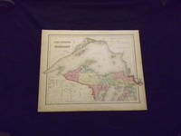
Colton's Map of Lake Superior and the Northern Part of Michigan.
by Colton, J.H
- Used
- Condition
- Used
- Quantity Available
- 1
- Seller
-
Florham Park, New Jersey, United States
- Item Price
-
£77.23
Show Details
Item Price
£77.23

Lake Superior and the northern part of Michigan
by COLTON, J.H
- Used
- Condition
- Used
- Quantity Available
- 1
- Seller
-
New York, New York, United States
- Item Price
-
£101.61
Show Details
Description:
New York: J.H. Colton, 1855. unbound. Map. Engraving with original hand coloring. Image measures 13" x 16 1/4"<br/> <br/> Beautifully detailed map of Lake Superior and northern Michigan divided into counties. Shows public land survey plats, towns, waterways, islands, topographical features, and mines. In excellent condition. <br> <br> The Colton family was one the most prolific and successful publishers of maps and atlases in the United States. Joseph Hutchins Colton (1800-1893) founded his map publishing business upon moving to New York in 1831. For the first two decades of his business, he found immense success publishing guide books marketed to emigrants and tourists. In 1855, he published the firm's first original atlas, "Colton's Atlas of the World", in collaboration with his son, George W. Colton (1827-1901). George and his brother, Charles B. Colton (1832-1916), assumed direction of the firm in the following decade.<br/> <br/>
Item Price
£101.61

MAP: "Johnson's Michigan & Wisconsin (1861)'...from Johnson's New Illustrated (Steel Plate) Family Atlas, 1861
by Colton, J.H. & Johnso, A.J. (compiled, Drawn & Engraved by)
- Used
- very good
- Paperback
- first
- Condition
- Used - Very Good
- Edition
- 1st
- Binding
- Paperback
- Quantity Available
- 1
- Seller
-
Hagerstown, Maryland, United States
- Item Price
-
£142.26
Show Details
Description:
Richmond, VA: Johnson & Browning, 1861. Plate #45, 46; lovely double page hand-colored map; of Michigan & Wisconsin at the beginning of the Civil War, decorative strapwork border; w/ Counties, cities, roads, rivers, railroads, wagon roads,canals, ports, etc. & w/inset engraving; seam reinforced. 1st. Unbound. Very Good. Illus. by Handcolored Map. 17 x 24.5 Inches.
Item Price
£142.26

More Photos
The Western Tourist and Emigrant's Guide through the States of Ohio, Michigan, Indiana, Illinois, and Missouri, Iowa and Wisconsin, and the Territories of Minesota [sic.], Missouri, and Nebraska ... Accompanied with a large and minute Map
by COLTON, J.H. (publisher) - John Calvin SMITH
- Used
- Condition
- Used
- Quantity Available
- 1
- Seller
-
New York, New York, United States
- Item Price
-
£569.03
Show Details
Description:
New York: published by J.H. Colton, 1852. 89pp. plus 18pp. catalogue of maps, etc., published by Colton. Large folding map: Smith, J. Calvin: "Guide Through Ohio, Michigan, Indiana, Illinois, Missouri, Wisconsin & Iowa, Showing the Township lines of the United States Surveys, Location of Cities, Towns, Villages, Post Hamlets, Canals, Rail and Stage Roads." New York: J.H. Colton, 1852. Full period colour, 21 7/8 x 26 3/8 inches. (Front free endpaper glued down to the front pastedown, small abrasion on the title). Publisher's green cloth covers, upper cover pictorially stamped in gilt, the lower cover repeating the design in blind. Colton's Western Tourist, complete with the folding map. This 1852 edition not recorded by Howes. The map depicts the region as far west as the Missouri river. Howes S615; Ristow, p.316.
Item Price
£569.03

More Photos
The Western Tourist and Emigrant's Guide : through the states of Ohio, Michigan, Indiana, Illinois, Missouri, Iowa, and Wisconsin, and the territories of Minnesota, Missouri, and Nebraska ; being an accurate and concise description of each state and territory ; and containing the routes and distances on the great lines of travel ; accompanied with a large and minute map
by COLTON, J.H
- Used
- near fine
- Hardcover
- Condition
- Used - Near Fine
- Binding
- Hardcover
- Quantity Available
- 1
- Seller
-
COLUMBIA, Missouri, United States
- Item Price
-
£609.68
Show Details
Description:
1854 HUGE MAP Colton's Western Tourist Emigrant's Guide Americana CaliforniaJ.H. Colton founded an American mapmaking company in the early 1830s which became an international leader in the map publishing industry until 1890. Colton created railroad maps, immigrant guides, elaborate atlases, and more all printed using engraved steel plates, which produced higher quality prints than maps made with less costly wax engravings, which were often separately hand water colored. and were recognized for their decorative borders.
J.H. Colton's 'Western Tourist and Emigrant's Guide'is an important 19th-century geographical book with an enormous folding map of the American 'west' including Ohio, Missouri, Indiana and Wisconsin. According to Howes, this work includes descriptions and material on California, Oregon, and Texas, with overland routes and westward expansion.
Item number: #13174
Price: $750
COLTON, J.H.
The Western Tourist and Emigrant's Guide : through the states of Ohio, Michigan, Indiana,… Read More
Item Price
£609.68

More Photos
THE WESTERN TOURIST AND EMIGRANT'S GUIDE THROUGH THE STATES OF OHIO, MICHIGAN, INDIANA, ILLINOIS, MISSOURI, IOWA, AND WISCONSIN, AND THE TERRITORIES OF MINESOTA, MISSOURI, AND NEBRASKA. BEING AN ACCURATE AND CONCISE DESCRIPTION OF EACH STATE AND TERRITORY; AND CONTAINING THE ROUTES AND DISTANCES ON THE GREAT LINES OF TRAVEL. ACCOMPANIED WITH A LARGE AND MINUTE MAP, EXHIBITING THE TOWNSHIP LINES OF THE UNITED STATES' SURVEYS, THE BOUNDARIES OF COUNTIES, AND THE POSITION OF CITIES, VILLAGES AND SETTLEMENTS, ETC., ETC.
by Colton, J.H
- Used
- Condition
- Used
- Quantity Available
- 1
- Seller
-
Woodbridge, Connecticut, United States
- Item Price
-
£609.68
Show Details
Description:
New York: J.H. Colton, 1856. Bound in original gilt-decorated publisher's cloth, with title stamped in gilt on front cover and in blind on rear cover. Spine cloth missing but covers firm [extremities rubbed]. 89, [1 blank], 34, [1], [1 blank] pp. A clean text with occasional mild foxing. The large folding map, attached to the rear pastedown, has a few short edge splits. It is hand-colored and entitled, 'Guide Through Ohio, Michigan, Indiana, Illinois, Missouri, Wisconsin & Iowa...by J. Calvin Smith. New York: J.H. Colton. 1855.' Very Good. Howes S615. Apparently not at AAS as of September 2021.
Item Price
£609.68

The Western Tourist, or Emigrants Guide, through the States of Ohio, Michigan, Indiana, Illinois, Missouri, Iowa, and Wisconsin, and the Territories of Minnesota, Missouri and Nebraska…
by Colton, J.H
- Used
- very good
- Condition
- Used - Very Good
- Quantity Available
- 1
- Seller
-
Florham Park, New Jersey, United States
- Item Price
-
£609.68
Show Details
Description:
Folding map, original gilt lettered cloth, hand colored folding map (45x54cm), 89, +23, [3] ad pp. Cloth splitting and torn along spine, a few chips, foxing to preliminaries and later leaves, old inkstamp to front endpaper; map bright and clean. J.H. Colton ((1800-1893) founded a map making dynasty that began in New York in the early 1830s. Colton produced his maps with steel engravings, resulting in good quality. During 1833-1855 Colton would produce a large number of very popular guidebooks and railroad maps. In 1855 he published his first large atlas, and his firm would publish atlases for many years. The current map has the attractive boarder, which was a trademark of Colton maps. The map features the states of Ohio, Michigan, Indiana, Illinois, Missouri, Wisconsin and Iowa, and the Nebraska and Minnesota territories. It also includes a small vignette view of the Mississippi River scene at the bottom. Howes S615.
Item Price
£609.68
The Western Tourist and Emigrant's Guide through the States of Ohio, Michigan, Indiana, Illinois, Missouri, Iowa, and Wisconsin and the territories of Minesota [sic], Missouri, and Nebraska. Being an Accurate and Concise Description of each State and Territory and Containing the Routes and Distances on the Great Lines of Travel. Accompanied with a large and minute map, exhibiting the township lines of the United States' surveys, the boundaries of counties, and the position of cities, villages and settlements, etc.,.
by [COLTON, J.H.]
- Used
- Hardcover
- first
- Condition
- Used
- Binding
- Hardcover
- Quantity Available
- 1
- Seller
-
Portland, Oregon, United States
- Item Price
-
£1,016.12
Show Details
Description:
New York: J.H. Colton, 1852. First edition. Twelvemo. 89, [1], 18 [publisher's ads] pp. Hand-colored fold-out map with engraved hand-colored ornate floral border, 20 x 26 inches, affixed at rear (as issued). Publisher's brown cloth with large and decorative gilt stamping and lettering on front, same image embossed in blind on rear. A virtually flawless copy; cloth with no rubbing or chipping, text extremely clean and map in beautiful shape.
Item Price
£1,016.12