Description:
Titolo: Italy according to the Newest Observations Autore: Herman Moll (1654-1732) Data: 1740 circa Dimensioni del foglio: 290 x 215 mm. Dimensioni dell'incisione alla battuta: 257 x 182 mm. Tecnica: incisione su rame acquarellata a mano Condizioni generali: Ottime condizioni. Piegature. Herman Moll di orgine incerta (Germania o Provincie Unite) si stabilì a Londra dove iniziò la produzione di mappe sia sciolte che raccolte in atlanti. A Londra frequentava spesso Il Jonathan's Coffehouse dove conobbe lo scienziato Robert Hooke, gli scrittori Daniel Defoe, Jonathan Swift, i pirati William Dampier, William Hacke e Woodes Rogers e l'archeologo William Stukeley.Title: Italy according to the Newest Observations Author: Herman Moll (1654-1732) Date: 1740 circa Size of the page: 290x215 mm. Size of the engraving: 257x182 mm. Technique: copper engraving coloured by hand Conditions: Very good conditions. Foldings Herman Moll of uncert origin (Germany or United Provinces)…
Read More A Map of the West-Indies or the Islands of America in the North Sea with ye adjacent countries... by Moll, Herman, 1654?-1732
by Moll, Herman, 1654?-1732

A Map of the West-Indies or the Islands of America in the North Sea with ye adjacent countries...
by Moll, Herman, 1654?-1732
- Used
[London, Moll, between 1708 and 1720]. Framed map, 59 x 101 cm. Title continues: explaining what belongs to Spain, England, France, Holland & c. also ye trade winds, and ye several tracts made by ye Galeons and ye Flota... by Herman Moll geographer. The first impression of this engraved and hand-colored map of economic, geographical, and political importance. References: Phillips Atlases 5961 no. [10]. Framed in wood. Stock#MAP0101.
-
Seller
The Owl at the Bridge
 (US)
(US)
- Book Condition Used
- Quantity Available 1
- Publisher [London, Moll, between 1708 and 1720]
- Keywords Maps: Before 1800

More Photos
ITALY ACCORDING TO THE NEWEST OBSERVATIONS
by Herman Moll (1654-1732)
- Used
- Condition
- Used
- Quantity Available
- 1
- Seller
-
Foligno (PG), Italy
- Item Price
-
£261.42
Show Details
Item Price
£261.42

New England, New York, New Jersey, and Pensilvania & c.
by Herman Moll (1654-1732)
- Used
- very good
- Condition
- Used - Very Good
- Quantity Available
- 1
- Seller
-
Toronto, Ontario, Canada
- Item Price
-
£306.15
Show Details
Description:
London, c.1708. Very Good. Notes: Detailed and rare map of Northeast part of the United States before the Independence (French English Wars period)., Size : 184x262 (mm), 7.24x10.31 (Inches), Coloring: Black & White, Category: Maps United States New England (States);
Item Price
£306.15

Africa
by Herman Moll (1654-1732)
- Used
- very good
- Condition
- Used - Very Good
- Quantity Available
- 1
- Seller
-
Toronto, Ontario, Canada
- Item Price
-
£306.15
Show Details
Description:
London, c.1729. Very Good. Notes: Map of Africa, by Herman Moll published in Atlas minor. , Size : 202x275 (mm), 7.95x10.83 (Inches), Coloring: Hand Colored, Category: Maps Africa Continent;
Item Price
£306.15

Persia.
by Herman Moll (1654-1732)
- Used
- Condition
- Used - Very Good; narrow right margin
- Quantity Available
- 1
- Seller
-
Toronto, Ontario, Canada
- Item Price
-
£306.15
Show Details
Description:
London, 1701. Very Good; narrow right margin. Notes: For the shape of the Caspian Sea, Moll follows Olearius, distancing himself from the 17th century Dutch tradition of depicting it in oval shape. The boundaries of the provinces are clearly marked. It was published during the reign of the Safavid dynasty. , Size : 173x188 (mm), 6.81x7.40 (Inches), Coloring: Hand Colored in Outline, Reference: Alai General Maps of Persia E.223, Category: Maps Asia Middle East Iran, Iraq;
Item Price
£306.15

A New & Exact Map of the Electorate of Brunswick -Lunenburg and ye rest of ye Kings Dominions in Germany.
by Herman Moll (1654-1732)
- Used
- Condition
- Used - Very Good, with some skillful restorations; backed on acid free tissue paper for long term preservation.
- Quantity Available
- 1
- Seller
-
Toronto, Ontario, Canada
- Item Price
-
£469.43
Show Details
Description:
London: J. & T. Bowles, c.1720. Very Good, with some skillful restorations; backed on acid free tissue paper for long term preservation.. Notes: Large and detailed map of Germany by Herman Moll (1654-1732). It has a large and very decorative cartouche. With two inset maps: The Dutche of Saxon Lauwenburg. A Map of Part of England, the United Provinces, Westphalia and the Dominions of the King of Great Britain in Germany, shewing the Route of the Kings Journey from Hannover to Greenwich & c., Size : 620x1022 (mm), 24.41x40.24 (Inches), Coloring: Hand Colored, Category: Maps Europe Germany;
Item Price
£469.43

Les Provinces Des Pays-Bas Catholiques ou A Most Exact Map of Flanders or ye Austrian Netherlands & c.
by Herman Moll (1654-1732)
- Used
- Condition
- Used - Very Good, backed on original linen
- Quantity Available
- 1
- Seller
-
Toronto, Ontario, Canada
- Item Price
-
£489.84
Show Details
Description:
London: J. & T. Bowles, c.1720. Very Good, backed on original linen. Notes: Large and detailed map of the Netherlands by Herman Moll (1654-1732). It referrers to the Austrian Netherlands; Austria was given the Netherlands in the treaty of Utrecht (signed in 1712). The map has three inset maps: A Plan of all manner of works used in Fortification with the method of an Attack. A Map of the Roads from Paris to Valenciene. The South Part of Luxembourgh., Size : 617x1002 (mm), 24.29x39.45 (Inches), Coloring: Hand Colored, Category: Maps Europe Benelux;
Item Price
£489.84
More Photos
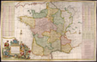
A New and Exact Map of France Dividid into all its Provinces and Acquisitions, according to the Newest Observations, and that accurate Survey made by the King's Command by Mr. Picar and de la Hire, with the Post Roads and the Computed Leagues from Town to Town, and the Passes of the Pirenean Mountains and many other Remarcks &c
by MOLL, Herman (1654-1732)
- Used
- Condition
- Used
- Quantity Available
- 1
- Seller
-
New York, New York, United States
- Item Price
-
£612.30
Show Details
Description:
London: J. Bowles, P. Overton, T. Bowles, John King, 1740. Hand-coloured engraving. Repaired loss to bottom left corner outside neat line with facsimile border. Trimmed to platemark in places in top margin. Three vertical creases where map was folded into atlas. Multiple creases parallel to center fold. Splits in vertical folds have been rebacked. A superb map of France during the reign of Louis XV. This large, marvellous Moll map of France bears his distinctive style and the fruits of his diligence. There is a lengthy, alphabetical index of more than 280 towns giving their distances from Paris as well as names and locations of passes through the Pyrenees. The source for this information was Nicolas de Fer. The depiction of France itself includes the roads and the distances from point to point on those roads in leagues, a relatively new feature in maps. Also noted, by a sword and date, are battle sites in which the English were involved or "mentioned in History" as he puts it. The cartouche includes…
Read More Item Price
£612.30

More Photos
A New & Exact Map of the Electonate of Brunswick-Lunenburg and ye rest of ye Kings Dominion in Germany
by MOLL, Herman (1654-1732)
- Used
- Condition
- Used
- Quantity Available
- 1
- Seller
-
New York, New York, United States
- Item Price
-
£693.94
Show Details
Description:
London: H. Moll, T. & J. Bowles, P. Overton & J. King, 1730. Copper-engraved map, with original outline colour, in excellent condition. A magnificent map celebrating the ascension of the House of Hanover to the British throne, depicting the new King's German possessions. Herman Moll first printed this map immediately after George I came to the throne of Great Britain. Queen Anne (Stuart) died without heir, and after the legislated exclusion of her close, but Catholic, relatives, her distant Protestant cousin, the Elector of Hanover, was deemed to be her legitimate heir. It is amusing to note that even though George I ruled from 1714 to 1728, it is said that he never learned to speak more than a few words of the "King's English." This map principally focuses on the large region of northern Germany that was ruled by George, one of the princes of the Holy Roman Empire. As depicted on the map, this realm included the great port of Hamburg, as well as the important cities of Lünenberg and Hanover, and…
Read More Item Price
£693.94

A New Map of the Upper Part of Italy Containing ye Principality of Piemont ye Dutchies of Savoy, Milan, Parma, Mantua, Modena, Tuscany, the Dominions of ye Pope &c. The Republics of Venice, Genoa, Lucca & c.
by Herman Moll (1654-1732)
- Used
- Condition
- Used - Very Good, with some skillful restorations; backed on acid free tissue paper for long term preservation.
- Quantity Available
- 1
- Seller
-
Toronto, Ontario, Canada
- Item Price
-
£775.58
Show Details
Description:
London: J. & T. Bowles, c.1720. Very Good, with some skillful restorations; backed on acid free tissue paper for long term preservation.. Notes: Large and detailed map of Northern Italy by Herman Moll (1654-1732). It has plans of Venice, Mantua, Milan, Turin, Genoa, Placenza, Parma, Modena, Florenza, Rome and Civita Vecchia; plus A Prospect of the Town and Harbour of Leghorn., Size : 626x1040 (mm), 24.65x40.94 (Inches), Coloring: Hand Colored, Category: Maps Europe Italy;
Item Price
£775.58

A New and Exact Map of the United Provinces, or Netherlands & c.
by Herman Moll (1654-1732)
- Used
- Condition
- Used - Very Good, with some skillful restorations; backed on acid free tissue paper for long term preservation.
- Quantity Available
- 1
- Seller
-
Toronto, Ontario, Canada
- Item Price
-
£816.40
Show Details
Description:
London: J. & T. Bowles, c.1720. Very Good, with some skillful restorations; backed on acid free tissue paper for long term preservation.. Notes: Large and detailed map of the Netherlands by Herman Moll (1654-1732).With inset plans and views of Amsterdam, Rotterdam, Middleburg, Utrecht, Groningen and The Late King William's Pallace called T'Loo., Size : 628x1035 (mm), 24.72x40.75 (Inches), Coloring: Hand Colored, Category: Maps Europe Benelux;
Item Price
£816.40