
Click for full-size.
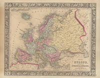
Map of Europe, Showing Its Gt. Political Divisions
by (EUROPE -- Map)
- Used
- Condition
- See description
- Seller
-
Galena, Illinois, United States
Payment Methods Accepted
About This Item
New York: S. Augustus Mitchell, Jr., 1860. Folio (15¼" X 12¼", image area 13¼" X 10½"). Hand colored. Very good. Mild age toning. A bright and clean continental map, from the 1864 edition of "Mitchell's New General Atlas, Containing Maps of the Various Countries of the World, Plans of Cities, Etc." A superb example, nicely colored and with fine decorative border.
Reviews
(Log in or Create an Account first!)
Details
- Seller
- Main Street Fine Books & Manuscripts, ABAA
 (US)
(US)
- Seller's Inventory #
- 45846
- Title
- Map of Europe, Showing Its Gt. Political Divisions
- Author
- (EUROPE -- Map)
- Book Condition
- Used
- Quantity Available
- 1
- Publisher
- S. Augustus Mitchell, Jr.
- Place of Publication
- New York
- Date Published
- 1860
- Bookseller catalogs
- Maps;
- Product_type
- Map
Terms of Sale
Main Street Fine Books & Manuscripts, ABAA
Main Street Fine Books & Manuscripts accepts most major credit cards and PayPal. Checks are welcome. Institutions will be accommodated as their procedures require. Every effort has been made to describe each book and any defects accurately. If an item proves unsatisfactory for any reason, it may be returned within seven days. We would appreciate a courtesy call if an item is being returned. Member ABAA, ILAB, MWABA, The Manuscript Society.
About the Seller
Main Street Fine Books & Manuscripts, ABAA
Biblio member since 2005
Galena, Illinois
About Main Street Fine Books & Manuscripts, ABAA
Main Street Fine Books & Manuscripts has been serving book lovers, collectors and institutions since 1991. Our inventory of quality out-of-print books spans 50 subjects, while the extensive autograph holdings have a decidedly historical bent, reflecting personages from every field of human endeavor.
Glossary
Some terminology that may be used in this description includes:
This Book’s Categories

Collecting Aleister Crowley
Aleister Crowley was a well-known and highly controversial figure in the first half of the 20th Century. A writer, occultist, magician, and mountaineer, Crowley impacted a diverse collection of sub-cultures and interests. See collectible Crowley from Biblio booksellers.

Collect modern first editions
Biblio is showcasing the top book published every year starting in 1919. See if your favorite modern first edition made the list! Check out our collecting first editions by the year.