
Click for full-size.
MAP of the COUNTY of ORLEANS by David H Burr
by Burr, David maps&prints
- Used
- Hardcover
- first
- Condition
- NEAR FINE map. Map #49 from Burr's 1829 New York State Atlas.
- Seller
-
Lyndonville, New York, United States
Payment Methods Accepted
About This Item
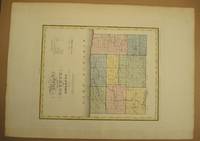
Burr. NEAR FINE map. Map #49 from Burr's 1829 New York State Atlas.. 1829. 1st edition. Hardcover. NEAR FINE map. Hand colored in shades of olive, light green & light pink. 15.5"x12.75" @ plate marks. Overall 20"x16" . Engraved by Rawdon, Clark of Albany & Rawdon, Wright of N York. Plate marks 15.5"x12.75", map about 2" less in both dimensions. Few spots or areas of light aging, foxing or soiling. BUT: verso heavily browned, likely from contact with acidic matt paper. This browning is not focing and is only on verso. In 1829 the Erie Canal had been open for less than ten years. About half the lots are numbered and their owners can be identified. No individual houses are marked. There are a half dozen symbols for mills, churches, etc. From Burr's "ATLAS of the STATE of NEW YORK", just the 2nd atlas of an American state. Burr was a protege of Simeon De Witt, George Washington's chief map maker. After the Revolutionary War De Witt was NYS surveyor General, under whose auspices this map was published ..... as stated on the map. .
Reviews
(Log in or Create an Account first!)
Details
- Bookseller
- Quiet Friends
 (US)
(US)
- Bookseller's Inventory #
- 001500
- Title
- MAP of the COUNTY of ORLEANS by David H Burr
- Author
- Burr, David maps&prints
- Illustrator
- Hand colored map
- Format/Binding
- Hardcover
- Book Condition
- New NEAR FINE map. Map #49 from Burr's 1829 New York State Atlas.
- Edition
- 1st edition
- Publisher
- Burr
- Date Published
- 1829
- Keywords
- NEAR FINE map. Hand colored in shades of olive, light green & light, pink. 15.5"x12.75" @ plate marks. Overall 20"x16"
- Bookseller catalogs
- New York;
Terms of Sale
Quiet Friends
Visa, M/C, MO, Check. Shipping is free for a "regular" weight book. But for heavier books, and multi volume sets, we ask for any additional postage. Basically we pay the first $3.
About the Seller
Quiet Friends
Biblio member since 2008
Lyndonville, New York
About Quiet Friends
We sell about 75% internet, 25% book fairs. We have been in business since the early 90's. We pack extremely well. We describe very conservatively and have only a few returns in the 5000 orders we have mailed.
Glossary
Some terminology that may be used in this description includes:
- Plate
- Full page illustration or photograph. Plates are printed separately from the text of the book, and bound in at production. I.e.,...
- Fine
- A book in fine condition exhibits no flaws. A fine condition book closely approaches As New condition, but may lack the...
- Verso
- The page bound on the left side of a book, opposite to the recto page.
- New
- A new book is a book previously not circulated to a buyer. Although a new book is typically free of any faults or defects, "new"...
Frequently asked questions
This Book’s Categories

Learn about Bayntun-Rivière Binders
Are you enchanted by books clad in fine bindings? This is the gallery for you to peruse! Learn more about Bayntun, Rivière & Sons, and their combined work as Bayntun-Rivière.

Collecting Signed Books
Read through our tips, hints, and information on collecting books signed or inscribed by the author or illustrator.