Click for full-size.
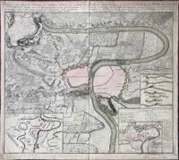
Kriegs-Expeditions-Karte in Bohmen I. Blat, in welchem die Haubtstadt Prag mit der Franzossischen und Saechsischen Belagerug und Eroberung, so den 26 Novembre 1941. / Carte des Expeditions de Guerre en Boheme, I Feuille dans laquette se voit le Plan de la Ville de Prague, assiegee et prise par les Troupes auxiliaires de France et de Saxe en l'An 1741, le 26. Novembre.
by Homann (Johann Baptist)
- Used
- Condition
- See description
- Seller
-
Sidney, British Columbia, Canada
Payment Methods Accepted
About This Item
Nuremberg: Homann Erben (Homann Heirs), 1743. . A copper engraved map on laid paper, uncoloured decorative cartouche in upper left corner, inset maps in lower corners, text in German and French at top; text on map is in French. Map is partially coloured, inset maps coloured. Imprint at top: geschehen, vor gestellet wird. Ans Licht gestellt von Homoen Erben A1743 (and in French:) mise au jour par les Heritiers de Homan, l'An 1743. Verso blank. Plate measures 57cm x 51cm, on a sheet measuring 60cm x 54cm. Margins have been strengthened and slightly extended by pasting paper strips to the verso all the way around. Tear in upper margin, a couple of creases, tape repair on verso at top of fold, old stain to upper right corner; a clean very good copy. This map describes the 1741 Battle of Prague during the War of the Austrian Secession. The upper left cartouche prints a Legende, which contains an alphabetical key to locations and events, while the inset map at the lower right contains an alphabetical key to the French camps within Prague in 1742.
Reviews
(Log in or Create an Account first!)
Details
- Bookseller
- William Matthews, Bookseller / The Haunted Bookshop
 (CA)
(CA)
- Bookseller's Inventory #
- 55998
- Title
- Kriegs-Expeditions-Karte in Bohmen I. Blat, in welchem die Haubtstadt Prag mit der Franzossischen und Saechsischen Belagerug und Eroberung, so den 26 Novembre 1941. / Carte des Expeditions de Guerre en Boheme, I Feuille dans laquette se voit le Plan de la Ville de Prague, assiegee et prise par les Troupes auxiliaires de France et de Saxe en l'An 1741, le 26. Novembre.
- Author
- Homann (Johann Baptist)
- Book Condition
- Used
- Quantity Available
- 1
- Publisher
- Nuremberg: Homann Erben (Homann Heirs), 1743.
- Weight
- 0.00 lbs
- Bookseller catalogs
- Maps;
Terms of Sale
William Matthews, Bookseller / The Haunted Bookshop
Prices are in US Dollars. Books are guaranteed to be as described. Books may be returned within a reasonable length of time. Paypal Payments are made to: bill@rainbownorth.com
About the Seller
William Matthews, Bookseller / The Haunted Bookshop
Biblio member since 2004
Sidney, British Columbia
About William Matthews, Bookseller / The Haunted Bookshop
Established 1976. Open shop in Victoria BC, Open Wed-Sun 11-5. Specialists in weird, fantastic, supernatural,utopian, interplanetary, science fiction and lost race fiction; also rare books, literary first editions, poetry broadsides. Antiquarian maps, charts, views, prints, engravings.
This Book’s Categories

Collecting History of the Circus in America
Step right up! Take a look at the center ring, where you will see displayed the most amazing, most colorful series of history books that the world has ever seen! Right this way, folks…

Collecting Books on NYC
This gallery is dedicated to some of the best fiction and nonfiction portraying one of the greatest cities in the world. We Heart NYC! Enjoy browsing these books on New York City.
Also Recommended
-

-

-

-
-

Save 10% on every purchase!
Join the Bibliophiles’ Club and start saving 10% on every book.
$29.95 / Year
