Description:
Fuji Journal Company. , 1974. Book. Good. Hardcover. IN JAPANESE; Minerals Atlas of the People's Republic of China, with 46 large maps; hardcover; owner's stamps; corners bumped; maps are separated from binding, but all are present and in good condition. This is a heavy atlas; extra shipping may be required for priority mail or international orders. .
Japanese Atlas Of China -
Similar copies are shown below.
Similar copies are shown to the right.

Japanese Atlas of China
- Used
- Hardcover
1920. Hardcover. Atlas from the period of the Japanese invasion of Manchuria. Numerous color double page maps of China, including topography, climate zones, rainfall, population density, railway lines, mineral resources, city plans, and regional maps. In September 1931 Japan invaded Manchuria immediately following the Mukden Incident; it established the puppet state of Manchukuo. The occupation lasted until 1945. Page 37 with much added manuscript lines over Taiwan, with 2 incomplete dark blue rubber stamps, and arrows pointing from China toward Taiwan. Pencil markings on p23 to the north of Peking. 4to, 58 pp of color maps of China. Well thumbed, one map loose, o/w good condition. Paper covered boards, title printed in red and white at front board.
-
Bookseller
Antipodean Books, Maps & Prints
 (US)
(US)
- Format/Binding Hardcover
- Book Condition Used
- Quantity Available 1
- Binding Hardcover
- Date Published 1920
We have 3 copies available starting at £36.58.

[ The People's Republic of China - Mining and Industry Distribution Maps ] Atlas, IN JAPANESE.
by Chinese Economy Studying Group of Juji Journal
- Used
- good
- Hardcover
- Condition
- Used - Good
- Binding
- Hardcover
- Quantity Available
- 1
- Seller
-
Stephenville, Texas, United States
- Item Price
-
£36.58
Show Details
Item Price
£36.58
The Chicago & North-Western Russian-Japanese War Atlas: showing Russia-in-Europe and Russia-in-Asia, Japan, Korea, Manchuria, and China, and the entire theater of operations in the Far Eastern Conflict
by [Atlas; Russo-Japanese War]
- Used
- Paperback
- first
- Condition
- Used - Very good condition
- Edition
- First printing
- Binding
- Paperback
- Quantity Available
- 1
- Seller
-
Garrison, New York, United States
- Item Price
-
£223.82
Show Details
Description:
Chicago: Rand McNally and Company; Chicago and North Western Railway Company, 1904. First printing. Staplebound Wraps. Very good condition. Maps of the Russo-Japanese War, five maps with a key printed in the margins, comprised by the North-Western Line on inside front cover (b&w), World map; Asia; Eastern China; Japan and Korea (all in color) and 'the Only Double-Track Railway Between Chicago and the Missouri River and the Route of the Overland Limited' inside the back cover (b&w). OCLC: 928938679 at Newberry Library, (Baskes Collection). Small folio, printed paper wrappers, grey covers with blue titles on front/back. Maps in color and b&w. Covers dusty, slt. chip on foredge, original folds.
Item Price
£223.82
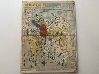
Japanese Colour Woodblock Historical Atlas of China. (Todo rekidai shugun enkaku chizu).
by China - Nagakubo, Sekisui
- Used
- Condition
- Used
- Quantity Available
- 1
- Seller
-
Vienna, Austria
- Item Price
-
£1,300.65
Show Details
Description:
1857. Edo, 1857. 36 : 24 cm. 13 coloured, double-page woodblock-maps. Japanese accordion binding, paper title-label on upper cover. This japanese historical atlas of Chinese maps traces Chinese history from the early times through to the Qing Dynasty. Includes the foreward from the 1789 first edition. The popular atlas contains the following maps: 1. (Dai Shinkoku doteizu) Map of the Broad World of Great Qing. - 2. (Uko kyushuzu) Yugong Map of the Nine Provinces. - 3. Shu Shokuho-shi-zu) Map of the Nine Provinces of Zhou Dynasty. - 4. (Shunju rekkokuzu) Map if the Five Nations of Chunqiu Period (Eastern Zhou Dynasty). - 5. (Sengoku shichiyuzu) Map of Seven States of Zhangou Period (Eastern Zhou Dynasty). - 6. (Shin sanjurokugun narabi ni Etsu shingun) Map of Thirty-six Administrative Regions of Qin Dynasty. - 7. (Seikan shugunzu) Map of Administrative Divisions and Subdivisions of Western Han Dynasty. - 8. (Tokan shungunzu) Map of Administrative Division of Eastern Han Dynasty. - 9.(Sangoku teijizu)…
Read More Item Price
£1,300.65