Description:
Map. Pen and ink with watercolor. Sheet measures 7 x 8.5".<br/><br/> This beautiful schoolgirl or schoolboy manuscript map of England and Wales beautifully depicts from Scotland south to the English Channel. Essentially two maps on a single sheet, the left map depicts the region with detailed topography throughout. Towns, rivers and mountains are noted with a key in the top left corner. The right hand side of the map depicts "The Saxon Heptarchy" and territories are numbered and shaded in. A key in the bottom right lists the territories numbered on the map. The Wall of Severus is identified. The speculative Wall of Severus was supposedly built by the Roman Emperor Septimius Severus as a defensive fortification, but was most likely mistaken for either the Antonine Wall or the Hardian's Wall. The map is in good condition with minor wear along the original centerfold. Small stain in the bottom of centerfold. Minor toning and foxing with some edge…
Read More Iles Britanniques by ANONYMOUS [Manuscript map]
by ANONYMOUS [Manuscript map]
![Iles Britanniques by ANONYMOUS [Manuscript map]](https://d3525k1ryd2155.cloudfront.net/h/411/194/859194411.0.m.jpg)
Iles Britanniques
by ANONYMOUS [Manuscript map]
- Used
Map. Pen and ink with watercolor. Image measures 18 x 12.5".<br/><br/> This anonymous pen and ink map of the British Isles was produced around the middle of the 19th century, likely by a student or apprentice as training in geography, drafting, and penmanship. The relative simplicity of the map suggests that the student was working from a school atlas as opposed to a more elaborate source. Major roads, rivers, and cities are all labeled, but the anonymous cartographer has clearly paid more attention to correctly rendering the coastlines of Great Britain and Ireland, as well as the surrounding smaller islands. The lettering is also exquisite, as the names of Irlande and Ecosse Angleterre are written to accentuated the shape of the islands. The coloring of the map, done in watercolor, corresponds to common patterns of the day, with a spectrum of blues used to highlight the islands and fill the surrounding water. Light brown watercolor has also been artfully applied to show areas of elevation. A finely written title at the top is flanked by a painter's palette in a black circle on the right and the Red Ensign flag on the left. A decorative gold border surrounds the map. The map is in good condition. Cropped bottom margin comes right to the border of the map. Manuscript map-making was a useful educational tool in the 19th century, a period of imperialism and increased world trade in which geography grew significantly as a field of study. In the United States and northwestern Europe, reform movements that sought to improve the quality and accessibility of childhood education pushed for the inclusion of geography in school curricula. One common method of teaching was the making of manuscript maps. Working from wall maps, globes, and atlases, students were made to meticulously hand-reproduce maps in pen and ink and with watercolor. Such exercises not only provided a way to review and retain geographical knowledge, but they also functioned as training in penmanship, calligraphy, and drafting. Today, these idiosyncratic projects offer a glimpse into the way 19th-century youth engaged with the world around them.<br/><br/>
-
Bookseller
Argosy Book Store
 (US)
(US)
- Book Condition Used
- Quantity Available 1
- Keywords manuscript
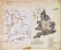
The Saxon Heptarchy. England and Wales
by ANONYMOUS [Manuscript map]
- Used
- Condition
- Used
- Quantity Available
- 1
- Seller
-
New York, New York, United States
- Item Price
-
£134.29
Show Details
Item Price
£134.29
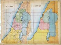
Canaan. Palestine
by ANONYMOUS [Manuscript map]
- Used
- Condition
- Used
- Quantity Available
- 1
- Seller
-
New York, New York, United States
- Item Price
-
£386.60
Show Details
Description:
Map. Pen and ink with watercolor. Image measures 7 x 8.5".<br/><br/> This beautifully hand colored schoolgirl or schoolboy manuscript map of Canaan and Palestine (Israel or Holy Land) covers from Arish in northern Sinai north beyond Beirut. The Sea of Galilee and the Dead Sea are included. Essentially two maps on the same sheet, the left hand map depicts the region as it existed during Biblical times, when it was called Canaan. The Twelve Tribes of Israel are identified along with ancient place names. Topography is beautifully rendered.<br><br>The right hand side map covers the same region, but is not labeled except for the title 'Palestine'. Territorial divisions are color coded. The map is in good condition with vivid hand color. On thin paper, with minor foxing and toning. Top margin with some manuscript text cut off. <br><br>This map dates to circa 1880 and was most likely made by a student or apprentice as training in geography, drafting, and…
Read More Item Price
£386.60