HODIERNAE BELGICAE five GERMANIA INFERIORIS Tabula
by CLUVER, Philipp
- Used
- Condition
- See description
- Seller
-
London, United Kingdom
Payment Methods Accepted
About This Item
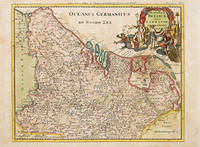
Atlas Geographus., 1711-17. A detailed and colourful map of what is now Belgium and part of north west Germany with Cluver's idiosyncratic elaborate cartouches. A library stamp on the reverse has been removed but shows slightly through and does not affect image. Copper engraving. Later colour. Very good condition Size: 26 x 21 cm. (10 x 8½ inches)
Reviews
(Log in or Create an Account first!)
Details
- Bookseller
- Peter Harrington
 (GB)
(GB)
- Bookseller's Inventory #
- 55147
- Title
- HODIERNAE BELGICAE five GERMANIA INFERIORIS Tabula
- Author
- CLUVER, Philipp
- Book Condition
- Used
- Place of Publication
- Atlas Geographus.
- Date Published
- 1711-17
Terms of Sale
Peter Harrington
All major credit cards are accepted. Both UK pounds and US dollars (exchange rate to be agreed) accepted. Books may be returned within 14 days of receipt for any reason, please notify first of returned goods.
About the Seller
Peter Harrington
Biblio member since 2006
London
About Peter Harrington
Since its establishment, Peter Harrington has specialised in sourcing, selling and buying the finest quality original first editions, signed, rare and antiquarian books, fine bindings and library sets. Peter Harrington first began selling rare books from the Chelsea Antiques Market on London's King's Road. For the past twenty years the business has been run by Pom Harrington, Peter's son.

Collecting Nebula Award Winners of the 1970s
The Nebula Award has been awarded to stories in the Science Fiction and Fantasy genre every year since 1966. Learn about the winners of the 1970s!

Collecting proofs, galleys, and advance reviews
Devoted collectors of rare books will love finding proofs, galleys, and advance review copies of their favorite pieces of literature. Find rare proofs and advance reading copies in the Rare Book Room.
