H. Kümmerlys Touristenkarte von Graubünden - Kuemmerly Carte routiere du canton des Grisons - Kuemmerly Travelling Map of the Canton of Grisons by Kümmerly, H - um 1900
by Kümmerly, H
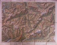
H. Kümmerlys Touristenkarte von Graubünden - Kuemmerly Carte routiere du canton des Grisons - Kuemmerly Travelling Map of the Canton of Grisons
by Kümmerly, H
- Used
Bern: Geographischer Kartenverlag H. Kümmerly & Frey & A. Francke, um 1900. Um 1900. Schöne farbige Faltkarte auf Leinenträger, Maßstaab 1 : 300000, Maße ausgefaltet 58 x 46,5 cm. Zum Teil angedunkelt und geknautscht.
-
Bookseller
ANTIQUARIAT WEBER
 (DE)
(DE)
- Book Condition Used
- Quantity Available 1
- Publisher Bern: Geographischer Kartenverlag H. Kümmerly & Frey & A. Francke
- Date Published um 1900
- Keywords Kümmerly's Karte ; Landkarte ; Schweiz ; Switzerland ; Suisse ;
- X weight 190 g
