Click for full-size.

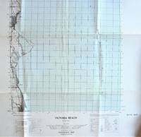
Fold-Out Topographical Survey Map. Victoria Beach, Manitoba
- Used
- very good
- Paperback
- Condition
- Very Good
- Seller
-
Calgary, Alberta, Canada
Payment Methods Accepted
About This Item
(Ottawa): The Army Survey Establishment/Department of National Defence., 1957 Map is scale 1: 50, 000 with water shaded in blue. Measures 30" by 22" with border. Shows: Houses schools, church, post officer, lighthouse, etc. Minor wear. Very Good.
Reviews
(Log in or Create an Account first!)
Details
- Bookseller
- Ken Jackson
 (CA)
(CA)
- Bookseller's Inventory #
- 256109
- Title
- Fold-Out Topographical Survey Map. Victoria Beach, Manitoba
- Format/Binding
- Soft cover
- Book Condition
- Used - Very Good
- Quantity Available
- 1
- Binding
- Paperback
- Publisher
- The Army Survey Establishment/Department of National Defence.
- Place of Publication
- (Ottawa)
- Date Published
- 1957
- Weight
- 0.00 lbs
- Keywords
- CARTOGRAPHY AND MAPS FOLD-OUT TOPOGRAPHICAL SURVEY MAP. VICTORIA BEACH, MANITOBA MAP BEACH CANADA
- Bookseller catalogs
- Cartography and Maps;
Terms of Sale
Ken Jackson
Any book may be returned for any reason. If not as described we will pay shipping both ways.
About the Seller
Ken Jackson
Biblio member since 2005
Calgary, Alberta
About Ken Jackson
We are a family business and have been involved in books since 1971.
This Book’s Categories

Collecting the Civil Rights Movement
The Civil Rights Movement of the 1960s and ’70s was an explosive time in American history, and it inspired explosive literature. From Malcolm X to Martin Luther King, Jr., browse some of the most collectible books from and about that era.

Collecting Aleister Crowley
Aleister Crowley was a well-known and highly controversial figure in the first half of the 20th Century. A writer, occultist, magician, and mountaineer, Crowley impacted a diverse collection of sub-cultures and interests. See collectible Crowley from Biblio booksellers.
