
Click for full-size.
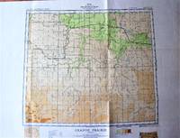
Fold-Out Topographical Survey Map in Co Lour. Sheet 83 N.W. Grande Prairie, Alberta
- Used
- near fine
- Paperback
- Condition
- Near Fine
- Seller
-
Calgary, Alberta, Canada
Payment Methods Accepted
About This Item
Ottawa: Geological Survey of Canada/Department of Mines., 1941 Map is scale 1 inch to 8 miles and measures 24" by 30" with border. Includes: Boundries, Railways, Abandoned Railway Grades, Main Highways, Secondary Roads, Towns, Villages, Telegraph or Telephone Lines, Ferries, Marsh or Swamp, Lookout Towers, and gives height in feet. One small tear, minor wear. Very Good.
Reviews
(Log in or Create an Account first!)
Details
- Bookseller
- Ken Jackson
 (CA)
(CA)
- Bookseller's Inventory #
- 256098
- Title
- Fold-Out Topographical Survey Map in Co Lour. Sheet 83 N.W. Grande Prairie, Alberta
- Format/Binding
- Soft cover
- Book Condition
- Used - Near Fine
- Quantity Available
- 1
- Binding
- Paperback
- Publisher
- Geological Survey of Canada/Department of Mines.
- Place of Publication
- Ottawa
- Date Published
- 1941
- Weight
- 0.00 lbs
- Keywords
- CARTOGRAPHY AND MAPS TOPOGRAPHIC MAP ALBERTA
- Bookseller catalogs
- Cartography and Maps;
Terms of Sale
Ken Jackson
Any book may be returned for any reason. If not as described we will pay shipping both ways.
About the Seller
Ken Jackson
Biblio member since 2005
Calgary, Alberta
About Ken Jackson
We are a family business and have been involved in books since 1971.
This Book’s Categories

Vertigo Comics
Vertigo Comics, an imprint of DC Comics, is being retired in 2020 after a 27 year run of groundbreaking comics. The imprint was DC’s home for mature tales that were often horror-themed or otherwise dark in nature. Learn more about Vertigo, home of V for Vendetta, Sandman, and Fables.

RIP (Please) George Romero: Modern Master of Zombie Horror
George Romero co-wrote and directed Night of the Living Dead in 1968, a film that inspired the modern zombie craze and made an indelible mark on American cinema. Come this way, horror fan...
