Description:
Philadelphia (Chestnut Street), 1822: HC Carey and I Lea, 1822. VG due to some minimal dampstaining most evident left upper corner, and minimally crossing neatline. The color portion of the map shows no significant visual effects from the stains. The original hand-colored image is clear and bright, with the surrounding letterpre ss text detailing aspects of population, climate, commerce, religion, government. There is a nice general historical sketch (in a separate page of original text, included here-- "Appendix to No. 18") in the letterpress. From the first edition "A Complete Historical, Chronological, and Geographical American Atlas...", which was also the first American atlas with letterpress printing on the map. This is a nice map, but for the defects described. The map image is 45x31cm; the entire image is 52.5x42cm..
Cram's Unrivaled Atlas of the World. Indexed by Cram, George F - 1888
by Cram, George F
Similar copies are shown below.
Similar copies are shown to the right.

Cram's Unrivaled Atlas of the World. Indexed
by Cram, George F
- Used
- Hardcover
Chicago: Henry S. Stebbins, Publisher, 1888. Hardcover. Twenty-first edition, revised to November 1, 1887. 231pp. Maroon bubble-grain pictorial cloth stamped in gold and black on the front panel and in blind on the rear panel. Decorated endpapers, marbled edges. Includes hundreds of maps in color; history and historical maps; diagrams with the comparative size of the countries of the world, the annual products, wealth and debt of the United States; area and population, increase of immigration, and the public debt of the United States; commerce, money circulation, railroads and telegraphs of every country in the world; statistics; illustrations. Front hinge a bit weak, mild soiling to cloth. Internally extremely clean. A very good+ copy, much better than usually found. ; Quarto.
-
Bookseller
Parigi Books, Vintage and Rare
 (US)
(US)
- Format/Binding Hardcover
- Book Condition Used
- Quantity Available 1
- Binding Hardcover
- Publisher Henry S. Stebbins, Publisher
- Place of Publication Chicago
- Date Published 1888
- Keywords non-fiction, ATLASES, UNITED STATES, MAPS
We have 1 copies available starting at £151.03.

(Map of Pennsylvania): Geographical, Statistical, and Historical Map of Pennsylvania
by Carey & Lea (engr.by Young & Delleker)
- Used
- Hardcover
- first
- Condition
- Used
- Binding
- Hardcover
- Quantity Available
- 1
- Seller
-
Crozet, Virginia, United States
- Item Price
-
£326.56
Show Details
Item Price
£326.56

More Photos
Plan of the Battle of Waterloo
by Edward Cotton
- Used
- good
- Hardcover
- Condition
- Used - Good
- Binding
- Hardcover
- Quantity Available
- 1
- Seller
-
Boonsboro, Maryland, United States
- Item Price
-
£260.02
Show Details
Description:
1854. Hardcover. Good. Lithograph map with original hand-colored highlights. Approximately 12 1/4 X 12 1/2" on 18 X 18" sheet with extensive printed text at all margins. Title and credit in the map at upper right, good condition with some aging at folds. <br> Original slim 12mo dark green leather-covered board folder with gilt lettering at upper cover. Some scuffing and wear at edges. Additional smaller lithograph map with hand-colored highlights mounted at inside of upper cover. Lengthy 1858 pencil notation of purchase ("on the Field of Waterloo") from Cotton's niece on verso of map.
Item Price
£260.02

More Photos
SMITH'S NEW MAP OF PHILADELPHIA AND VICINITY
by Smith, J. L.
- Used
- Hardcover
- Condition
- Used - Very Good+
- Binding
- Hardcover
- Quantity Available
- 1
- Seller
-
Fairfield, New Jersey, United States
- Item Price
-
£228.59
Show Details
Description:
Philadelphia: J. L. Smith. Very Good+. 1898. Hardcover. One large map Issued in two separate sheets; each 23" x 27 1/2". The folding maps are backed on linen. The maps are mounted in a green cloth hardcover folder with bright glit title on front. Pennsylvania; Thin 12mo 7" - 7½" tall .
Item Price
£228.59
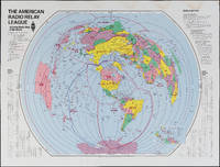
The Amateur Radio Relay League: Amateur Radio Map of the World
by American Radio Relay League
- Used
- Condition
- Used
- Quantity Available
- 1
- Seller
-
FRAMINGHAM, Massachusetts, United States
- Item Price
-
£265.33
Show Details
Description:
Color print on glossy paperDimensions: 31" x 40 3/4"Condition: as found, water stain along top margin, bright colors throughoutThis American Radio Relay League divides the world into radio relay league zones rather than political or geographic boundaries. The map could be thought of as a ham radio listeners "bird's ear" view of the world. Each zone is identified by the call letters for that zone, immediately recognizable to the experienced ham radio operator and part of a language unique to this kind of radio communication.
Item Price
£265.33
![Upper Mines Nos. 1 & 8 [and] Lower Mines No. 3 or Mormon Diggings; [Both on single sheet]...](https://d3525k1ryd2155.cloudfront.net/h/575/126/1453126575.0.m.jpg)
More Photos
Upper Mines Nos. 1 & 8 [and] Lower Mines No. 3 or Mormon Diggings; [Both on single sheet] [included in 30th Congress, Second Session, House, Executive Document No. 1, Message from the President ... James K. Polk, December 5 1848]
by Mason, Richard B. [James K. Polk]
- Used
- very good
- first
- Condition
- Used - Very Good
- Edition
- First Edition
- Binding
- Unknown
- Quantity Available
- 1
- Seller
-
Sebastopol, California, United States
- Item Price
-
£320.03
Show Details
Description:
Washington DC: Government Printing Office, 1848. First Edition. Very Good. [Sheet 10.5x8.25in, Neat line Upper 4.75x6.25in and Lower 4.125x6.25in]; The map shows the location of the Upper Mines Nos. 1 & 8 diggings along the South Fork of the American river, with roads buildings, including Shutter's Saw Mill and Marshall's house and distance to Sutters [Fort]. The Lower Mines No.3 or Mormon Diggings are also along the river and shows the Mormon Bar and labels the gold deposits, the store and road to Sutters. [Wheat Maps 52, Poore p. 567]. Richard Barnes Mason (1797-1850) was a United States Army officer and the fifth Military Governor of California (1847-1849). After gold was discovered by James Marshall at Sutter's Mill in January 1848, General Mason toured the Gold diggings along the American River north east of Sacramento in June, 1848. The report was written in Monterey in August 17, 1848. The Mason reports and maps were part of a larger Federal report to Congress on a number of subjects that…
Read More Item Price
£320.03

More Photos
Handy Map & Guide to London with index to Streets (Cruchley's Handy Map of London)
by No Author
- Used
- very good
- Paperback
- Condition
- Used - Very good
- Binding
- Paperback
- Quantity Available
- 1
- Seller
-
Southampton, Hampshire, United Kingdom
- Item Price
-
£225.00
Show Details
Description:
Gall & Inglis', 1870's-1880's. Paperback. Very good. VGC.Gall & Inglis'.No date given but probably 1870's to 1880's prior to London Tower Bridge build, which is not included on the map.Green hardback(small dents,nicks and light shelf wear on the cover) with folded map in VGC.The map is in VGC but with small stain marks and foxing marks on the edges,small tear on the edge of the map.The map is hand coloured and includes:Railways,Railway Stations,Steamer Routes,Omnibus and Tramway Routes,Parks.The size of the map is: 30x20 inch.The scale of the map is: 3 3/4 to 1 mile.The map covers: From Hyde Park(including parts of Kensington Palace) to Blackwall and from Mildmay Park to South Lambeth.The map is in VGC for its age. A collectable and scarce map.
Item Price
£225.00

More Photos
Portrait and Biographical Album of WILL COUNTY, ILLINOIS containing Full Page Portraits and Biographical Sketches of Prominent and Representative Citizens of the County 1890: 19th Century Geneology
by Chapman Brothers
- Used
- Hardcover
- first
- Condition
- Used - Good-
- Jacket Condition
- none
- Edition
- Later printing of the 1st edition, copyright 1885 Chapman
- Binding
- Hardcover
- Quantity Available
- 1
- Seller
-
Winfield, Illinois, United States
- Item Price
-
£204.10
Show Details
Description:
Book is in Very Good condition but the leather cover is fragile/Fair. All around gilt, spine is very worn and the hinges are cracked with the covers almost detached. 771 pages plus transportation. Also includes portraits and biographies of all the presidents of the U.S. and Governors of the State. A very large book, additional shipping outside the continental U.S.A.
Item Price
£204.10

More Photos
Arab navigation in the Indian Ocean before the coming of the Portuguese
by Ahmad ibn Majid al-Sadi , G.R. Tibbetts
- Used
- Hardcover
- first
- Condition
- Very Good: Cover some light shelf wear, inside as new
- Edition
- First Edition
- Binding
- Hardcover
- ISBN 10 / ISBN 13
- 9780718909000 / 0718909003
- Quantity Available
- 1
- Seller
-
Berg en dal, Netherlands
- Item Price
-
£209.14
Show Details
Description:
Ahmad ibn Majid al-Sadi, G.R. Tibbetts - Arab Navigation in the Indian Ocean before the coming of the Portuguese - London, The Royal Asiatic Society of Great Britain and Ireland; Luzac and Company Ltd, 1971 - First Edition - Hardcover - 614pp + 4 maps (out of 7)- 22x14 cmCondition Very Good: Cover some light shelf wear, inside as new. Four out of seven maps present: Chart of the Arabian Sea, India and the Bay of Bengal, Red Sea and Gulf of Eden, East African CoastIf you have any questions or want to see more pictures, feel free to ask.Your book will be securely packed and shipped with tracking number, signed & insured.
Item Price
£209.14

More Photos
1875 ILLINOIS CENTRAL MAP.: Map of the Illinois Central Railroad and its Connections.
- Used
- Condition
- Used
- Quantity Available
- 1
- Seller
-
Houston, Texas, United States
- Item Price
-
£240.84
Show Details
Description:
[Railroad] Map of the Illinois Central Railroad and its Connections. Chicago: Rand McNally and Company Map Engravers. 1875. Map printed on green paper. 33 x 25 on sheet 40 x 38 cm folded to 9 x 19 cm. Added text printed in green in margins around map. One three inch fold split, else very good.OCLC shows one holding (Newberry Lib.) Relief shown by hachures. Timetables on verso "corrected to June 20th, 1875." Text describing routes and connections on 5 panels on verso: Illinois Central Railroad principal connections -- Illinois Central Railroad Dubuque and Sioux City Line! -- Illinois Central Railroad, the direct route from Chicago to Springfield, Farmer City, Clinton and Mt. Pulaski -- Illinois Central Railroad St. Louis through line -- Illinois Central Railroad New Orleans through line.
Item Price
£240.84

More Photos
Travel and Adventure in the Territory of Alaska, 1869 First Edition
by Whymper, Frederick
- Used
- Hardcover
- first
- Condition
- Used - Very Good+
- Edition
- First
- Binding
- Hardcover
- Quantity Available
- 1
- Seller
-
Lincoln, Nebraska, United States
- Item Price
-
£254.51
Show Details
Description:
Travel and Adventure in the Territory of Alaska, Formerly Russian America--Now Ceded to the United States--and in Various Other Parts of the North Pacific. By Frederick Whymper. With Map and Illustrations. New York: Harper & Brothers, Publishers, Franklin Square. 1869. First Edition.Signed by W D Fenton, founder of the Oregon Historical Society.Illustrated frontispiece with original tissue guard, fold out map, wood engravings.Condition: Good Condition. NOT a library book. Please review photos and ask for more if necessary to make your best buying decision!
*Please Note: This item will be shipped to your address of record AND will require a verified signature upon receipt. Thank you for tracking your purchase and being available to sign for it upon delivery. We appreciate your business and hope to do business with you again!
**Attention International Buyers** For all standard international book orders, we will be using Asendia consolidated shipping through Biblio.com. If you should choose expedited… Read More
Item Price
£254.51

More Photos
Cram's Unrivaled atlas of the World Indexed
by Cram, George F
- Used
- fair
- Hardcover
- Condition
- Used - Fair
- Jacket Condition
- No Jacket
- Binding
- Hardcover
- Quantity Available
- 1
- Seller
-
Kalamazoo, Michigan, United States
- Item Price
-
£151.03
Show Details
Description:
George F. Cram, NY, 1893. Hardcover. Fair/No Jacket. This is the complete atlas of the World with all the plates and pages tightly bound from the Table of contents through the end of the index on page 370. The title page is detached. There are no covers. This copy could be used for framing the invidivual pl
Item Price
£151.03

More Photos
The Sky and the Forest
by Forester, C.S
- Used
- very good
- Hardcover
- first
- Condition
- Used - Very Good
- Jacket Condition
- Very Good
- Edition
- First Edition
- Binding
- Hardcover
- Quantity Available
- 1
- Seller
-
Salem, Oregon, United States
- Item Price
-
£28.48£17.09Save £13.96!
Show Details
Description:
C.S. Forester: The Sky and the Forest. Little, Brown and Company, Boston. Stated First Edition First Printing Thus August, 1948. Cover price $2.75. Used. VG BOOK/VG UNCLIPPED DUST JACKET. A story of a central Africa. By C.S. Forester, author of the Admiral Hornblower series.
Item Price
£28.48£17.09
Save £13.96
!
![Alaska and Klondike Region; [With inset of Klondike Region on the Upper Yukon detail] [From an...](https://d3525k1ryd2155.cloudfront.net/h/062/537/1339537062.0.m.jpg)
Alaska and Klondike Region; [With inset of Klondike Region on the Upper Yukon detail] [From an atlas, "Gazetteer of Alaska and Yukon Region " pp. 105 and 106]
by Miller, J. Martin
- Used
- very good
- Condition
- Used - Very Good
- Edition
- Unknown
- Quantity Available
- 1
- Seller
-
Sebastopol, California, United States
- Item Price
-
£31.84
Show Details
Description:
Chicago: J. Martin Miller, 1899. Unknown. Map. Very Good. [Map copyright 1899, printing date of Atlas later] [19.875x15.125in]; Colored map of Alaska with steamer routes from Portland and Seattle, insets of the Klondike Region on the Upper Yukon and Western portion of Aleutian Islands; On verso index of places and names with two large black and white images; Age toning to all edges, water stain marks on bottom, slight printing offset of colors, small chips and closed tears to lower edge;.
Item Price
£31.84

Zemepis Sveta - Monsunova Asie
by De La Blache, P. Vidal; Gallois, L
- Used
- Hardcover
- Condition
- Used - Very Good Condition
- Jacket Condition
- No Dust Jacket
- Binding
- Hardcover
- Quantity Available
- 1
- Seller
-
Oak Point, Texas, United States
- Item Price
-
£48.98
Show Details
Description:
Aventinum, Prague, Czechoslovakia, 1931. Hardcover. Very Good Condition/No Dust Jacket. Text entirely in Czech. Geography book on Asia with numerous photographs and maps. 1930 edition also available. Size: 4mo - over 9 3/4" - 12" tall. 400 pp. Pages are yellowed, but are tight and clean. Moderate shelfwear along the spine. Corners are lightly bumped. Quantity Available: 1. Shipped Weight: 3-5 pounds. Category: Travel & Places; Non-English Language::Czech; Pictures of this item not already displayed here available upon request. Inventory No: 001228. . Additional shipping charges may apply.
Item Price
£48.98

Zemepis Sveta - Monsunova Asie
by De La Blache, P. Vidal; Gallois, L
- Used
- Hardcover
- Condition
- Used - Very Good Condition
- Jacket Condition
- No Dust Jacket
- Binding
- Hardcover
- Quantity Available
- 1
- Seller
-
Oak Point, Texas, United States
- Item Price
-
£48.98
Show Details
Description:
Aventinum, Prague, Czechoslovakia, 1930. Hardcover. Very Good Condition/No Dust Jacket. Text entirely in Czech. Geography book on Asia with numerous photographs and maps. 1931 edition also available. Size: 4mo - over 9 3/4" - 12" tall. 400 pp. Pages are yellowed, but are tight and clean. Moderate shelfwear along the spine. Corners are lightly bumped. Quantity Available: 1. Shipped Weight: 3-5 pounds. Category: Travel & Places; Non-English Language::Czech; Pictures of this item not already displayed here available upon request. Inventory No: 001227. . Additional shipping charges may apply.
Item Price
£48.98

North America from the Best Authorities, Russell, ca.1800
by Russell
- Used
- Condition
- Used
- Quantity Available
- 1
- Seller
-
Plymouth, Devon, United Kingdom
- Item Price
-
£20.00
Show Details
Description:
Russell, J. : A General Map of North America from the Best Authorities. Nd but ca.1800. From "A New Geographical, Historical and Commercial Grammar and Present State of Several Kingdoms of the World." Copper engraving. Size approx 200 x 230mm. Two neat folds. Some age colouring to edges, otherwise very clean and bright.
Item Price
£20.00

Asia from the Best Authorities, Russell, ca.1800
by Russell
- Used
- Condition
- Used
- Quantity Available
- 1
- Seller
-
Plymouth, Devon, United Kingdom
- Item Price
-
£20.00
Show Details
Description:
Russell, J. : Asia from the Best Authorities. Nd but ca.1800. From "A New Geographical, Historical and Commercial Grammar and Present State of Several Kingdoms of the World". Copper engraving. Size approx 200 x 230mm. Two neat folds. Some age colouring to edges, otherwise clean and bright. Includes Arabia, India, Borneo, Japan, China and eastern Russia.
Item Price
£20.00
![MAP OF UTAH [Territory]](https://d3525k1ryd2155.cloudfront.net/h/836/461/1485461836.0.m.jpg)
More Photos
MAP OF UTAH [Territory]
- Used
- Condition
- Used - Very Good-
- Edition
- Original
- Quantity Available
- 1
- Seller
-
Williamsburg, Virginia, United States
- Item Price
-
£53.07
Show Details
Description:
New York, Richmond, Chicago, & Toledo: H. H. Hardesty, 1885. Original color lithographed map printed by Rand, McNally & Company, Engravers and published in HARDESTY'S HISTORICAL AND GEOGRAPHICAL ENCYCLOPEDIA: SPECIAL VIRGINIA EDITION. 19 3/8 inches by 13 1/4 inches on a 21" X 14 1/2" sheet. The map depicts the Territory of Utah in its final form--large areas had been removed and ceded to Nevada, Colorado, Wyoming, and Nebraska since Utah became a U. S. Territory in 1850. The issue of polygamy prevented statehood until it was finally granted in 1896. This map features railroads and topography and uses color to set off counties from each other. Unlike most atlas maps of the period, this map identifies most small towns. The map is guaranteed to be moe than 135 years old. The map is in about very good condition: generally clean and bright, with slight toning of paper and one faint water stain near the center-left edge of the map.. Original. Single Sheet. Very Good-. Elephant…
Read More Item Price
£53.07

Philips Special Map of the Nile, The Advance on Khartum and the Environs of Omdurman. Cc1900
by George Philips and Son,
- Used
- Condition
- Used
- Quantity Available
- 1
- Seller
-
Plymouth, Devon, United Kingdom
- Item Price
-
£26.00
Show Details
Description:
Philips Special map of the Nile illustrating the Advance on Khartum [Khartoum] with an enlargement of the environs of Omdurman [Omdur]. George Philips and Son, London and Liverpool Ca 1900. 580mm x 900mm folded map. Front title wrapper has come loose, not affecting map area. Three maps are displayed within the sheet. Map1. Map of the Nile Valley 520mm x 300mm showing the approaches of Khartum. Scale 1inch to 100 Geographical miles. Coloured indicating Possessions and Protectorates of European Powers. Map 2. Special map of the Nile from Dongola to Khartum. Scale 16 miles to the inch. Coloured. In set in this map is Map3. Environs of Omdurman, Scale 5 statute miles to the inch. Some small breaks at some folds, not affecting imagery or use of map. Title label is damaged, the map is clean and bright, probably unused. A very interesting record.
Item Price
£26.00

Last Tales
by Dinesen, Isak
- Used
- very good
- Hardcover
- first
- Condition
- Used - Very Good
- Jacket Condition
- Good+
- Edition
- First Edition
- Binding
- Hardcover
- Quantity Available
- 1
- Seller
-
Salem, Oregon, United States
- Item Price
-
£97.97£58.78Save £48.00!
Show Details
Description:
Dinesen, Isak: Last Tales, A Collection of Twelve New Tales of Compelling Beauty 1957, Random House. First Edition. Stated First Printing Thus. Used. Very Good/Good+ original red dust jacket, price-clipped. Jacket states 11/57 on front flap. 5 3/4 X
Item Price
£97.97£58.78
Save £48.00
!

The Adventure of Wrangel Island
by Vilhjalmur Stefansson
- Used
- good
- Hardcover
- first
- Condition
- Used - Good
- Jacket Condition
- No DJ Included
- Edition
- First Edition
- Binding
- Hardcover
- Quantity Available
- 1
- Seller
-
Salem, Oregon, United States
- Item Price
-
£101.96£61.17Save £49.96!
Show Details
Description:
The Adventure of Wrangel Island, Alaska (1925 Macmillan 1st Edition) HISTORY OF ALASKA. EXLIB. Good Condition/ No DJ included. Fold-out map affixed to binding at the back of the book has never been opened. The story of the (unsuccessful) attempted colonization of Wrangel Island Alaska. 413 pages plus appendix, Index. Titling is still bright. A clean, solid copy. Scarce.
Item Price
£101.96£61.17
Save £49.96
!