Click for full-size.
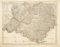
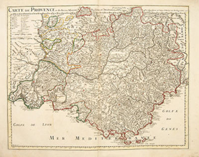
CARTE DE PROVENCE et des Terres Adjacentes: Map of Provence.
by DELISLE, Guillaume
- Used
- Condition
- See description
- Seller
-
London, United Kingdom
Payment Methods Accepted
About This Item
Paris. , c1715. Delisle was an important French cartographer of the early 18th century. He held the position of First Royal Geographer to the King. A is a lovely map of Provence in southern France. It is extremely detailed with the various dioceses marked and the surrounding Bishopric of Arles and The Comtat Venaissin to the north. A key top left explains the symbols and abbreviations. The Mediterranean sea and the Golf of Lyon and Genes are in the south. From the Atlas Geographique. Copper engraving. Original outline colour. Very good condition - some very light brown marks on image. Size: 61 x 48.4 cm.
Reviews
(Log in or Create an Account first!)
Details
- Bookseller
- Peter Harrington
 (GB)
(GB)
- Bookseller's Inventory #
- 55281
- Title
- CARTE DE PROVENCE et des Terres Adjacentes
- Author
- DELISLE, Guillaume
- Book Condition
- Used
- Place of Publication
- Paris.
- Date Published
- c1715
Terms of Sale
Peter Harrington
All major credit cards are accepted. Both UK pounds and US dollars (exchange rate to be agreed) accepted. Books may be returned within 14 days of receipt for any reason, please notify first of returned goods.
About the Seller
Peter Harrington
Biblio member since 2006
London
About Peter Harrington
Since its establishment, Peter Harrington has specialised in sourcing, selling and buying the finest quality original first editions, signed, rare and antiquarian books, fine bindings and library sets. Peter Harrington first began selling rare books from the Chelsea Antiques Market on London's King's Road. For the past twenty years the business has been run by Pom Harrington, Peter's son.

Michael Bond - the man behind Paddington Bear
“All the same ... it’s a very important name. And I don’t expect there are many bears in the world called Paddington!”
A lonely toy bear on an empty shop shelf on Christmas Eve in 1956 first captured the attention of Michael Bond, who kindly shared Paddington with the world.

Is your family bible valuable?
While they may have sentimental value, bibles passed down through the family are not often worth a lot of money. Learn more...
