
Click for full-size.
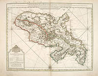
CARTE DE L'ISLE DE LA MARTINIQUE,: Colonie Francoise de l'une des Isles Antilles de l'Amerique.
by DELISLE, Guillaume
- Used
- Condition
- See description
- Seller
-
London, United Kingdom
Payment Methods Accepted
About This Item
Paris., 1732. Delisle was an important French cartographer of the early 18th century. He held the position of First Royal Geographer to the King. This is his very detailed map of the French island of Martinique. The mountainous regions are shown and the coast is wonderfully delineated. Published in the Atlas de Geographie. Copper engraving. Original outline colour. Good condition - lower corner margins slight dark patches; very slight browning to centrefold; some offsetting and ink showing through from reverse in upper margin. Size: 62.5 x 48.5 cm. (24½ x 19 inches)
Reviews
(Log in or Create an Account first!)
Details
- Bookseller
- Peter Harrington
 (GB)
(GB)
- Bookseller's Inventory #
- 55254
- Title
- CARTE DE L'ISLE DE LA MARTINIQUE,
- Author
- DELISLE, Guillaume
- Book Condition
- Used
- Place of Publication
- Paris.
- Date Published
- 1732
Terms of Sale
Peter Harrington
All major credit cards are accepted. Both UK pounds and US dollars (exchange rate to be agreed) accepted. Books may be returned within 14 days of receipt for any reason, please notify first of returned goods.
About the Seller
Peter Harrington
Biblio member since 2006
London
About Peter Harrington
Since its establishment, Peter Harrington has specialised in sourcing, selling and buying the finest quality original first editions, signed, rare and antiquarian books, fine bindings and library sets. Peter Harrington first began selling rare books from the Chelsea Antiques Market on London's King's Road. For the past twenty years the business has been run by Pom Harrington, Peter's son.

Bob Dylan - 2016 Winner of the Nobel Prize for Literature
From the first screech of his electric guitar upsetting musicians at a folk festival to his writing and paintings, Bob Dylan has risen to become a seminal force in American popular culture. In 2016, he was recognized by the Nobel Committee. Learn more about his creations...

Collecting Dr. Seuss
Whether you are into the pricey first editions or interesting Seussiana ephemera, this is a good starting point for building a book collection based on Dr. Seuss.
